
File:RAAFAreaCommands1942.png
No higher resolution available.
RAAFAreaCommands1942.png (348 × 367 pixels, file size: 18 KB, MIME type: image/png)
| This is a file from the Wikimedia Commons. Information from its description page there is shown below. Commons is a freely licensed media file repository. You can help. |
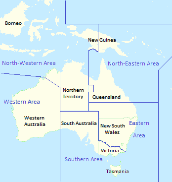
| Description | Royal Australian Air Force area commands as at November 1942. |
| Date | (UTC) |
| Source |
|
| Author |
|
| This is a retouched picture, which means that it has been digitally altered from its original version. Modifications: Superimposed names and boundaries of RAAF area commands as at November 1942. The original can be viewed here: Range of Senecio angulatus-Australasia.svg:
|
I, the copyright holder of this work, hereby publish it under the following licenses:
| This file is licensed under the Creative Commons Attribution-Share Alike 3.0 Unported license. | ||
| ||
| This licensing tag was added to this file as part of the GFDL licensing update. |

|
Permission is granted to copy, distribute and/or modify this document under the terms of the GNU Free Documentation License, Version 1.2 or any later version published by the Free Software Foundation; with no Invariant Sections, no Front-Cover Texts, and no Back-Cover Texts. A copy of the license is included in the section entitled GNU Free Documentation License. |
You may select the license of your choice.
Original upload log
This image is a derivative work of the following images:
- File:Range_of_Senecio_angulatus-Australasia.svg licensed with Cc-by-sa-3.0-migrated, GFDL
- 2008-04-02T04:53:25Z CarolSpears 738x527 (187189 Bytes) {{Information |Description=Range of ''Senecio angulatus'' in the [[Australasia]]. |Source=[[:Image:Ecozone-Biocountries-Australasia.svg|Map of Australasia]] and [http://floraseries.landcareresearch.co.nz/pages/Taxon.aspx?id=
Uploaded with derivativeFX
File history
Click on a date/time to view the file as it appeared at that time.
| Date/Time | Thumbnail | Dimensions | User | Comment | |
|---|---|---|---|---|---|
| current | 12:28, 23 August 2015 | | 348 × 367 (18 KB) | Ian Rose | Standardise colour in continent |
| 09:16, 28 July 2015 |  | 348 × 367 (18 KB) | Ian Rose | Tidy NWA/WA border line, centre "Wales" | |
| 10:56, 18 July 2015 |  | 348 × 367 (17 KB) | Hohum | Cartographic colours | |
| 01:07, 14 July 2015 |  | 348 × 367 (31 KB) | Ian Rose | Tweak North-Eastern/Eastern boundary | |
| 07:06, 29 December 2010 |  | 348 × 367 (35 KB) | Ian Rose | Fix eastern bounradies | |
| 06:31, 29 December 2010 |  | 377 × 367 (36 KB) | Ian Rose | {{Information |Description=Range of ''Senecio angulatus'' in the Australasia. |Source=*File:Range_of_Senecio_angulatus-Australasia.svg |Date=2010-12-29 06:27 (UTC) |Author=*File:Range_of_Senecio_angulatus-Australasia.svg: [[User:CarolSpear |
File usage
The following pages on the English Wikipedia use this file (pages on other projects are not listed):
- Central Area Command (RAAF)
- Eastern Area Command (RAAF)
- North-Eastern Area Command
- North-Western Area Command
- Northern Area Command (RAAF)
- Western Area Command (RAAF)
- Wikipedia:WikiProject Military history/News/May 2016/Articles
- Wikipedia talk:Featured article candidates/Eastern Area Command (RAAF)/archive1
- Portal:Military history of Australia
Global file usage
The following other wikis use this file:
- Usage on fr.wikipedia.org
- Usage on pt.wikipedia.org
- Portal:Aviação/Artigo em Destaque
- Comando da Área Noroeste da RAAF
- Comando da Área Nordeste da RAAF
- Comando da Área Oriental da RAAF
- Comando da Área Central da RAAF
- Comando da Área Ocidental da RAAF
- Comando da Área do Norte da RAAF
- Wikipédia:Artigos destacados/arquivo/Área de Comando Oriental da RAAF
- Wikipédia:Artigos destacados/arquivo/Área de Comando Ocidental da RAAF
- Wikipédia:Artigos destacados/arquivo/Área de Comando Noroeste da RAAF
- Portal:Aviação/Artigo em Destaque/Arquivo/Comando da Área Nordeste da RAAF
- Usage on www.wikidata.org