
File:Redclyffe Bridge and Waiohiki 3 March 2023.jpg
Size of this preview: 800 × 450 pixels. Other resolutions: 320 × 180 pixels | 640 × 360 pixels | 1,024 × 576 pixels | 1,280 × 720 pixels | 2,560 × 1,440 pixels | 4,128 × 2,322 pixels.
Original file (4,128 × 2,322 pixels, file size: 3.14 MB, MIME type: image/jpeg)
| This is a file from the Wikimedia Commons. Information from its description page there is shown below. Commons is a freely licensed media file repository. You can help. |
Summary
| Description |
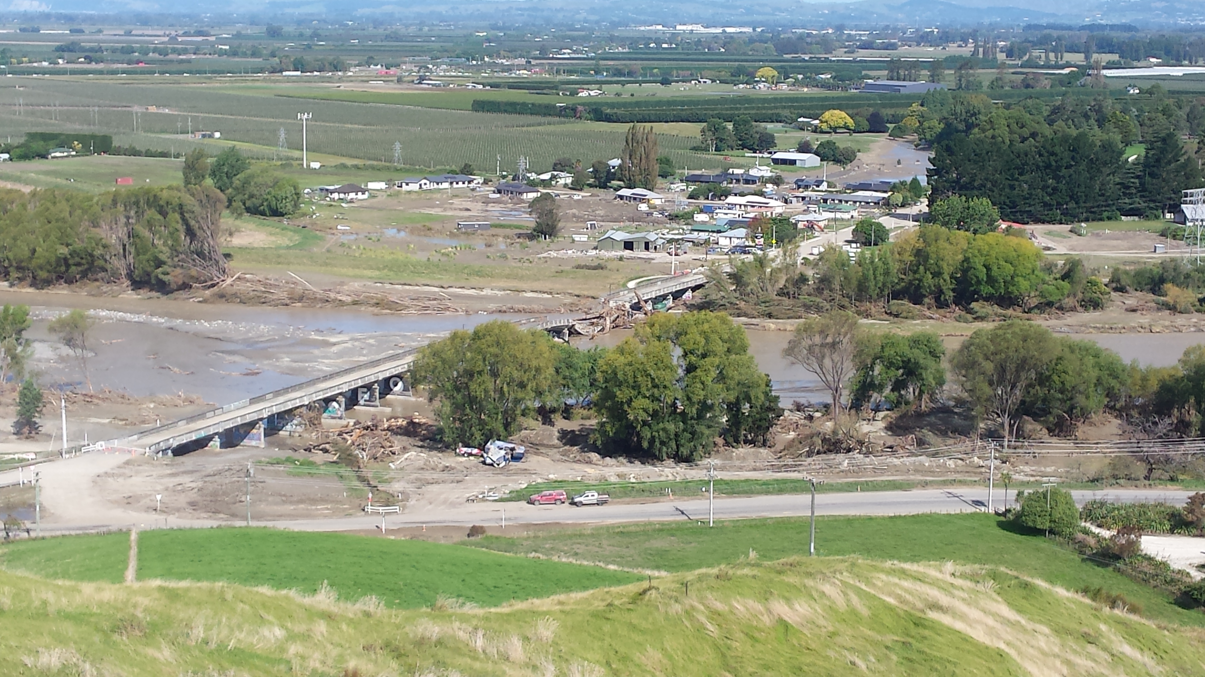
English: Redclyffe Bridge across the Tutaekuri River and the settlement of Waiohiki 17 days after Cyclone Gabrielle, viewed across Springfield Road from the Otatara Pa site. The bridge has been snapped in two near the Waiohiki end. Debris (mostly woody) caught on the bridge is being removed. Some riverbank trees have been flattened. Repairs and silt removal is underway in Waiohiki, much of which was flooded. Silt covers the lower part of the marae (at right), but floodwater did not reach the meeting house (white roof behind power pylon at far right). Water flowed over the deck of the bridge and the part of Springfield Road nearest the camera, where silt remains on the near side of the road. |
| Date | |
| Source | Own work |
| Author | Nurg |
| Camera location | | View this and other nearby images on: OpenStreetMap |
|---|
Licensing
I, the copyright holder of this work, hereby publish it under the following license:
This file is licensed under the Creative Commons Attribution-Share Alike 4.0 International license.
- You are free:
- to share – to copy, distribute and transmit the work
- to remix – to adapt the work
- Under the following conditions:
- attribution – You must give appropriate credit, provide a link to the license, and indicate if changes were made. You may do so in any reasonable manner, but not in any way that suggests the licensor endorses you or your use.
- share alike – If you remix, transform, or build upon the material, you must distribute your contributions under the same or compatible license as the original.
File history
Click on a date/time to view the file as it appeared at that time.
| Date/Time | Thumbnail | Dimensions | User | Comment | |
|---|---|---|---|---|---|
| current | 03:58, 5 March 2023 | | 4,128 × 2,322 (3.14 MB) | Nurg | Uploaded own work with UploadWizard |
File usage
The following pages on the English Wikipedia use this file (pages on other projects are not listed):