
File:Rupes Nigra.jpg
No higher resolution available.
Rupes_Nigra.jpg (564 × 477 pixels, file size: 421 KB, MIME type: image/jpeg)
| This is a file from the Wikimedia Commons. Information from its description page there is shown below. Commons is a freely licensed media file repository. You can help. |
| This image appeared on Wikipedia's Main Page in the Did you know? column on 22 November 2011 (see archives). |
| Description |
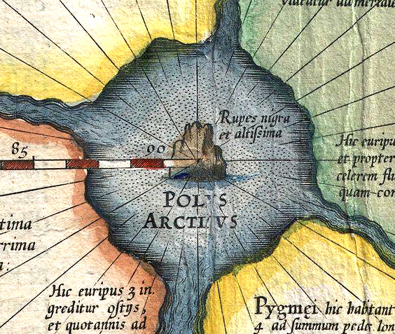
English: Mercator: Septentrionalium Terrarum descriptio. A map of the North Pole. Detail showing “Rupes nigra et altissima”, the “black and very high rock”.
Deutsch: Ausschnitt aus Gerardus Mercators Karte Septentrionalium Terrarum descriptio, einer Karte der Nordpolarregion, mit dem „Rupes nigra et altissima“, dem „schwarzen und sehr hohen Felsen“ direkt am Nordpol. |
||||||||||||||||||||||||||
| Date | |||||||||||||||||||||||||||
| Source | Cropped from 1606 Mercator Hondius Map of the Arctic (First Map of the North Pole) - Geographicus - NorthPole-mercator-1606.jpg. | ||||||||||||||||||||||||||
| Author |
|
||||||||||||||||||||||||||
| Permission (Reusing this file) |
|
||||||||||||||||||||||||||

_-_Geographicus_-_NorthPole-mercator-1606.jpg)
File history
Click on a date/time to view the file as it appeared at that time.
| Date/Time | Thumbnail | Dimensions | User | Comment | |
|---|---|---|---|---|---|
| current | 05:34, 6 January 2015 | | 564 × 477 (421 KB) | Gretarsson | considerably better resolution, although different colouration |
| 03:11, 5 May 2009 |  | 200 × 171 (20 KB) | Goustien | {{Information |Description={{en|1=Mercator: Septentrionalium Terrarum descriptio. A map of the North Pole. Detail showing "Rupes nigra et altissima," the "very high black rock"}} |Source=http://www.themaphouse.com/specialistcat/mythical/polar111d.jpg |Aut |
File usage
The following pages on the English Wikipedia use this file (pages on other projects are not listed):
Global file usage
The following other wikis use this file:
- Usage on ca.wikipedia.org
- Usage on cs.wikipedia.org
- Usage on de.wikipedia.org
- Usage on es.wikipedia.org
- Usage on it.wikipedia.org
- Usage on no.wikipedia.org
- Usage on sl.wikipedia.org