
File:Sectional & road map of Los Angeles County - including part of Orange and Ventura counties, showing the oil and mining districts LOC 2012592099.jpg

Size of this preview: 546 × 600 pixels. Other resolutions: 218 × 240 pixels | 437 × 480 pixels | 699 × 768 pixels | 932 × 1,024 pixels | 1,864 × 2,048 pixels | 8,247 × 9,059 pixels.
Original file (8,247 × 9,059 pixels, file size: 14.17 MB, MIME type: image/jpeg)
| This is a file from the Wikimedia Commons. Information from its description page there is shown below. Commons is a freely licensed media file repository. You can help. |
Summary
| Description |
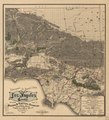
English: Relief shown by hachures. Partial cadastral map showing roads, locations of old ranchos, oil districts, mining districts, and refineries. LC Land ownership maps, 25 Available also through the Library of Congress Web site as a raster image. |
||
| Title | Sectional & road map of Los Angeles County : including part of Orange and Ventura counties, showing the oil and mining districts | ||
| Shelf ID | G4363.L6 1900 .G4 | ||
| Date | |||
| Source | https://www.loc.gov/item/2012592099/ | ||
| Author | George, A. L.; Stoll & Thayer | ||
| Permission (Reusing this file) |
|
||
| Other versions |
|
||
| Location | United States · California · Los Angeles County | ||
| Part of | American Memory · Catalog · County Landownership Maps · Geography And Map Division · Cultural Landscapes | ||
| Subject | Cadastral Maps · Mines And Mineral Resources · Los Angeles County (Calif.) · Los Angeles County · United States · Maps · California · Real Property · Landowners |

Licensing
|
This is a faithful photographic reproduction of a two-dimensional, public domain work of art. The work of art itself is in the public domain for the following reason:
The official position taken by the Wikimedia Foundation is that "faithful reproductions of two-dimensional public domain works of art are public domain".
This photographic reproduction is therefore also considered to be in the public domain in the United States. In other jurisdictions, re-use of this content may be restricted; see Reuse of PD-Art photographs for details. | ||||
File history
Click on a date/time to view the file as it appeared at that time.
| Date/Time | Thumbnail | Dimensions | User | Comment | |
|---|---|---|---|---|---|
| current | 05:41, 26 July 2018 | | 8,247 × 9,059 (14.17 MB) | Fæ | LOC Maps https://www.loc.gov/item/2012592099/ #13351 |
File usage
The following pages on the English Wikipedia use this file (pages on other projects are not listed):