
File:Shackleton Endurance Aurora map2.png
Size of this preview: 488 × 600 pixels. Other resolutions: 195 × 240 pixels | 502 × 617 pixels.
Original file (502 × 617 pixels, file size: 30 KB, MIME type: image/png)
| This is a file from the Wikimedia Commons. Information from its description page there is shown below. Commons is a freely licensed media file repository. You can help. |
Summary
| Description |
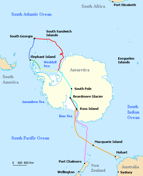
Map of the routes of the ships Endurance and Aurora, the support team route, and the planned trans-Antarctic route of the British Imperial Trans-Antarctic Expedition led by Ernest Shackleton in 1914–15. Voyage of Endurance
Drift of Endurance in pack ice
Sea ice drift after Endurance sinks
Voyage of the lifeboat James Caird
Planned trans-Antarctic route
Voyage of Aurora to Antarctica
Retreat of Aurora
Supply depot route |
| Date | |
| Source | Based on Image:ShackletonEnduranceBlank.png, which is a modification by User:Like tears in rain of Image:Antarctica Map.png, a U.S. government work in the public domain, further modified by User:Finetooth |
| Author | Finetooth, Like tears in rain, U.S Central Intelligence Agency |
| Other versions |
|

Licensing
I, the copyright holder of this work, hereby publish it under the following licenses:

|
Permission is granted to copy, distribute and/or modify this document under the terms of the GNU Free Documentation License, Version 1.2 or any later version published by the Free Software Foundation; with no Invariant Sections, no Front-Cover Texts, and no Back-Cover Texts. A copy of the license is included in the section entitled GNU Free Documentation License. |
This file is licensed under the Creative Commons Attribution-Share Alike 3.0 Unported license.
- You are free:
- to share – to copy, distribute and transmit the work
- to remix – to adapt the work
- Under the following conditions:
- attribution – You must give appropriate credit, provide a link to the license, and indicate if changes were made. You may do so in any reasonable manner, but not in any way that suggests the licensor endorses you or your use.
- share alike – If you remix, transform, or build upon the material, you must distribute your contributions under the same or compatible license as the original.
You may select the license of your choice.
This image is in the public domain because it contains materials that originally came from the United States Central Intelligence Agency's World Factbook.
|
 |

|
This map image could be re-created using vector graphics as an SVG file. This has several advantages; see Commons:Media for cleanup for more information. If an SVG form of this image is available, please upload it and afterwards replace this template with
{{vector version available|new image name}}.
It is recommended to name the SVG file “Shackleton Endurance Aurora map2.svg”—then the template Vector version available (or Vva) does not need the new image name parameter. |
File history
Click on a date/time to view the file as it appeared at that time.
| Date/Time | Thumbnail | Dimensions | User | Comment | |
|---|---|---|---|---|---|
| current | 13:16, 8 April 2018 | | 502 × 617 (30 KB) | Hohum | Minor colour change |
| 19:31, 24 January 2008 |  | 502 × 617 (19 KB) | Finetooth | ||
| 23:51, 14 January 2008 |  | 502 × 617 (18 KB) | Finetooth |
File usage
The following pages on the English Wikipedia use this file (pages on other projects are not listed):
Global file usage
The following other wikis use this file:
- Usage on ar.wikipedia.org
- Usage on az.wikipedia.org
- Usage on cs.wikipedia.org
- Usage on da.wikipedia.org
- Usage on de.wikipedia.org
- Usage on eu.wikipedia.org
- Usage on fi.wikipedia.org
- Usage on he.wikipedia.org
- קבוצת ים רוס
- ויקיפדיה:ערכים מומלצים/המלצות קודמות/ינואר 2018
- ויקיפדיה:ערכים מומלצים/המלצות קודמות/ספטמבר 2020
- פורטל:ערכים מומלצים/ערכים/קבוצת ים רוס
- תבנית:ערך מומלץ 12 בינואר 2018
- תבנית:ערך מומלץ 11 בינואר 2018
- תבנית:ערך מומלץ 15 בספטמבר 2020
- תבנית:ערך מומלץ 16 בספטמבר 2020
- ויקיפדיה:ערכים מומלצים/המלצות קודמות/פברואר 2023
- תבנית:ערך מומלץ 18 בפברואר 2023
- Usage on it.wikipedia.org
- Usage on ja.wikipedia.org
- Usage on ka.wikipedia.org
- Usage on nl.wikipedia.org
- Usage on nn.wikipedia.org
- Usage on no.wikipedia.org
- Usage on pl.wikipedia.org
- Usage on pt.wikipedia.org
- Usage on ro.wikipedia.org
- Usage on zh.wikipedia.org