
File:Spanish general election map, 1936.png

Size of this preview: 800 × 536 pixels. Other resolutions: 320 × 214 pixels | 640 × 429 pixels | 1,024 × 686 pixels | 1,280 × 857 pixels | 2,560 × 1,714 pixels.
Original file (2,560 × 1,714 pixels, file size: 464 KB, MIME type: image/png)
| This is a file from the Wikimedia Commons. Information from its description page there is shown below. Commons is a freely licensed media file repository. You can help. |
Summary
| Description |
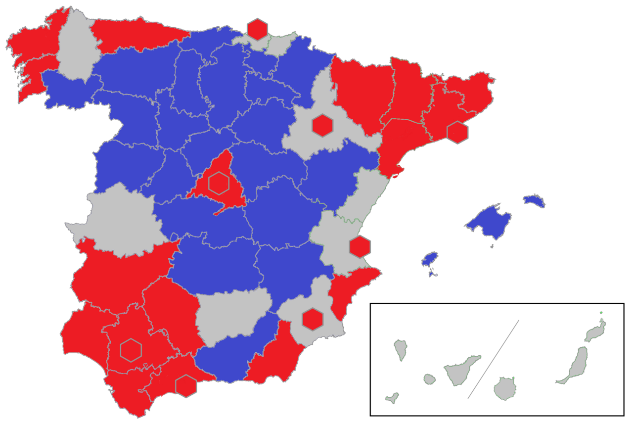
English: geographical perspective on outcome of the Spanish general elections of 1936. First round only. Own work based on data in: Manuel Alvarez Tardio, Roberto Villa Garcia, 1936. Fraude y violencia en las elecciones del Frente Popular, Barcelona 2017, tables on pp. 414-418.
Key:
Electoral districts were mostly equal to Spanish provinces. However, 8 large cities formed separate districts; on the map they are denoted as hexagons Please note that following 1) second round in some districts; 2) activity of Comision de Actas; 3) repeated elections in Cuenca and Granada, distribution of seats in the Cortes might have not reflected the results of voting in the first round |
| Date | |
| Source | https://commons.wikimedia.org/wiki/File:Spanish_general_election_map,_1933.svg |
| Author | own work (coloring, data) based on template map prepared by User:Jynus |
Licensing
This file is licensed under the Creative Commons Attribution-Share Alike 4.0 International license.
- You are free:
- to share – to copy, distribute and transmit the work
- to remix – to adapt the work
- Under the following conditions:
- attribution – You must give appropriate credit, provide a link to the license, and indicate if changes were made. You may do so in any reasonable manner, but not in any way that suggests the licensor endorses you or your use.
- share alike – If you remix, transform, or build upon the material, you must distribute your contributions under the same or compatible license as the original.
File history
Click on a date/time to view the file as it appeared at that time.
| Date/Time | Thumbnail | Dimensions | User | Comment | |
|---|---|---|---|---|---|
| current | 11:27, 28 December 2023 | | 2,560 × 1,714 (464 KB) | Hh1718 | cleared up some minor province-border glitches |
| 11:21, 28 December 2023 |  | 2,560 × 1,714 (469 KB) | Hh1718 | Uploaded a work by User:Jynus from https://commons.wikimedia.org/wiki/File:Spanish_general_election_map,_1933.svg with UploadWizard |
File usage
The following pages on the English Wikipedia use this file (pages on other projects are not listed):