
File:St. Anthony Sand Dunes, Idaho.jpg

Size of this preview: 600 × 600 pixels. Other resolutions: 240 × 240 pixels | 480 × 480 pixels | 768 × 768 pixels | 1,024 × 1,024 pixels | 2,048 × 2,048 pixels | 3,500 × 3,500 pixels.
Original file (3,500 × 3,500 pixels, file size: 4.59 MB, MIME type: image/jpeg)
| This is a file from the Wikimedia Commons. Information from its description page there is shown below. Commons is a freely licensed media file repository. You can help. |
Summary
| Description |
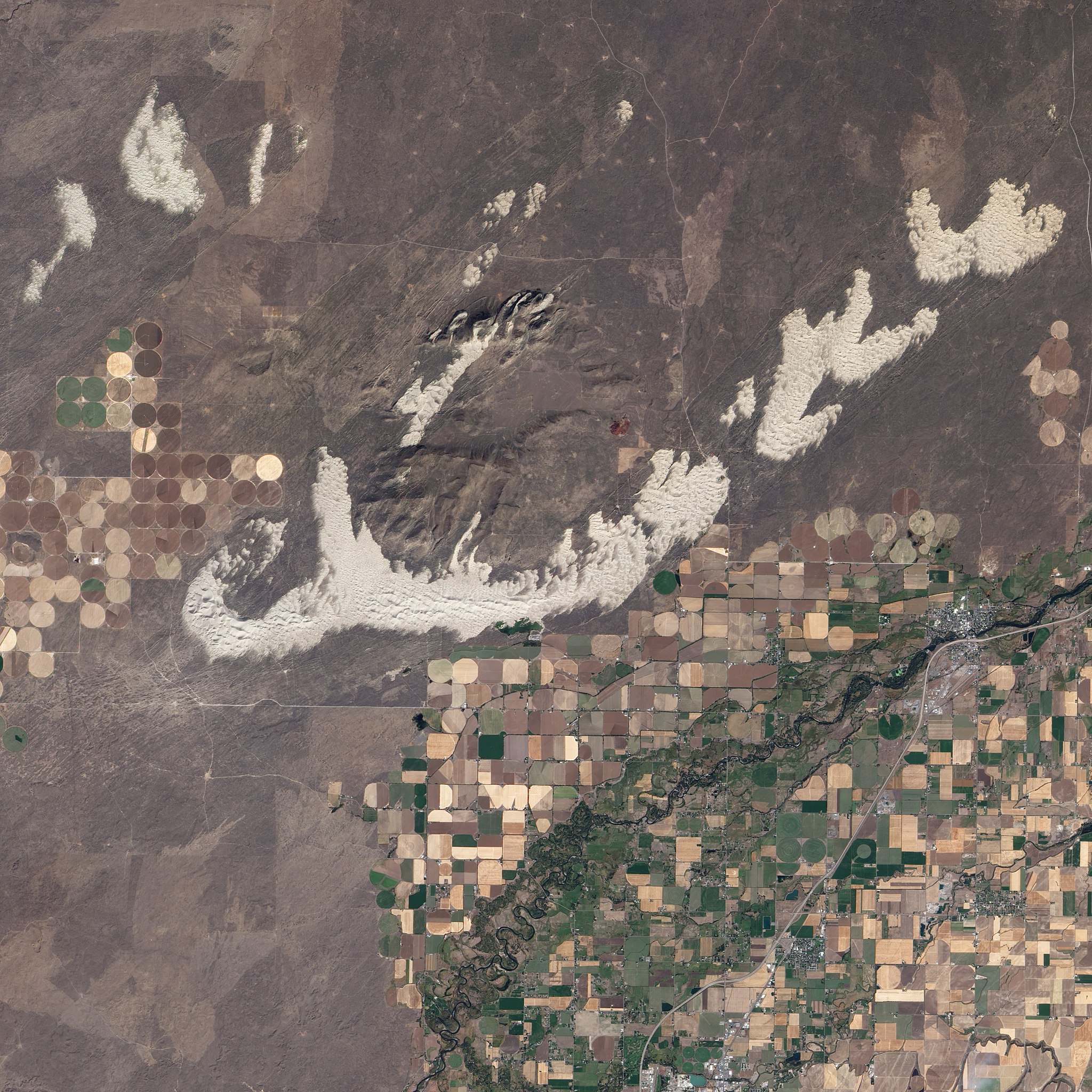
English: Dunes spill across the Snake River Plain in a wide arc in this detailed, photo-like image. Freshly harvested fields line the southern boundary of the dunes, and to the north is a darker brush-covered lava plain. The dunes formed about 10,000 years ago, at the end of the last ice age when the Earth’s climate shifted. Eastern Idaho’s climate became warmer and drier. Lakes shrank, exposing fine sand. Persistent winds from the south-west blew the sand north-east across the lava plain visible in the lower left corner of the image.
Dunes form only when sand encounters a soft surface or obstacle that prevents it from blowing away. The St. Anthony Dunes began to form when the sand reached the weathered mass of the Juniper Buttes, extinct volcanoes. Each individual dune forms a curve, with ends pointing north-east in the direction of the wind. This type of dune is a barchan dune, Arabic for ram’s horn. East of the volcanoes, the sand encountered another obstacle that kept it in place: more dunes. These older dunes, longitudinal dunes, are plant-covered sand dunes that formed in a previous, more arid climate, says Idaho State University geologist Paul Link. The longitudinal dunes formed on top of an old flood plain, from a branch of the Snake River, probably from sand blown from the river’s bank. The longitudinal dunes are long, dark stripes under the newer brilliant white dunes—layers of climate history visible at a glance. |
| Date | |
| Source | NASA Earth Observatory |
| Author | Jesse Allen and Robert Simmon |
Image acquired by the Advanced Land Imager on NASA’s EO-1 satellite. EO-1 ALI data provided courtesy of the NASA EO-1 team.
Licensing
| This file is in the public domain in the United States because it was solely created by NASA. NASA copyright policy states that "NASA material is not protected by copyright unless noted". (See Template:PD-USGov, NASA copyright policy page or JPL Image Use Policy.) | ||
 |
Warnings:
|
| Annotations | This image is annotated: View the annotations at Commons |
File history
Click on a date/time to view the file as it appeared at that time.
| Date/Time | Thumbnail | Dimensions | User | Comment | |
|---|---|---|---|---|---|
| current | 08:53, 29 September 2010 | | 3,500 × 3,500 (4.59 MB) | Originalwana | {{Information |Description={{en|1=Dunes spill across the Snake River Plain in a wide arc in this detailed, photo-like image. Freshly harvested fields line the southern boundary of the dunes, and to the north is a darker b |
File usage
The following pages on the English Wikipedia use this file (pages on other projects are not listed):