
File:St Helen, East Keal - geograph.org.uk - 430623.jpg
No higher resolution available.
St_Helen,_East_Keal_-_geograph.org.uk_-_430623.jpg (640 × 480 pixels, file size: 138 KB, MIME type: image/jpeg)
| This is a file from the Wikimedia Commons. Information from its description page there is shown below. Commons is a freely licensed media file repository. You can help. |
Summary
| Description |
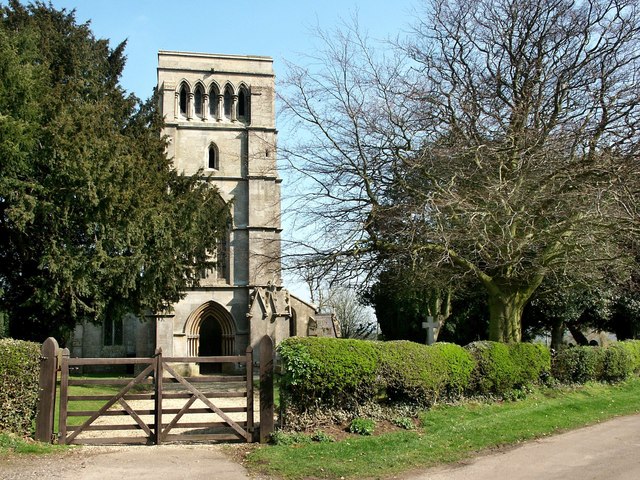
English: St Helen, East Keal The church of St Helen at East Keal, like that of St Helen at West Keal, stands on the very southern edge of the Wolds. It was almost entirely rebuilt in 1854 leaving just the south arcade, 13th-century and the north arcade, 14th-century. The octagonal 14th-century font has carvings flowers, leaves, grotesque heads and a bare backside!
In the south aisle, there is a small Elizabethan tablet inscribed Susanna Kirkman, which shows a seated figure, elbow resting on a skull with an extinguished torch in her other hand. There is also a bust of Peter Short who died in 1681. |
| Date | |
| Source | From geograph.org.uk |
| Author | Dave Hitchborne |
| Attribution (required by the license) | Dave Hitchborne / St Helen, East Keal / |
| Camera location | | View this and other nearby images on: OpenStreetMap |
|---|
_heading:90.00&language=en)
| Object location | | View this and other nearby images on: OpenStreetMap |
|---|
_heading:90.00&language=en)
Licensing

|
This image was taken from the Geograph project collection. See this photograph's page on the Geograph website for the photographer's contact details. The copyright on this image is owned by Dave Hitchborne and is licensed for reuse under the Creative Commons Attribution-ShareAlike 2.0 license.
|
This file is licensed under the Creative Commons Attribution-Share Alike 2.0 Generic license.
Attribution: Dave Hitchborne
- You are free:
- to share – to copy, distribute and transmit the work
- to remix – to adapt the work
- Under the following conditions:
- attribution – You must give appropriate credit, provide a link to the license, and indicate if changes were made. You may do so in any reasonable manner, but not in any way that suggests the licensor endorses you or your use.
- share alike – If you remix, transform, or build upon the material, you must distribute your contributions under the same or compatible license as the original.
File history
Click on a date/time to view the file as it appeared at that time.
| Date/Time | Thumbnail | Dimensions | User | Comment | |
|---|---|---|---|---|---|
| current | 09:02, 4 February 2011 | | 640 × 480 (138 KB) | GeographBot | == {{int:filedesc}} == {{Information |description={{en|1=St Helen, East Keal The church of St Helen at East Keal, like that of St Helen at West Keal, stands on the very southern edge of the Wolds. It was almost entirely rebuilt in 1854 leaving just the so |
File usage
The following pages on the English Wikipedia use this file (pages on other projects are not listed):
Global file usage
The following other wikis use this file:
- Usage on ceb.wikipedia.org
- Usage on cy.wikipedia.org
- Usage on fa.wikipedia.org
- Usage on fr.wikipedia.org
- Usage on it.wikipedia.org
- Usage on lld.wikipedia.org
- Usage on nl.wikipedia.org
- Usage on sv.wikipedia.org
- Usage on www.wikidata.org