
File:St Margarets Hertfordshire.JPG
No higher resolution available.
St_Margarets_Hertfordshire.JPG (265 × 154 pixels, file size: 11 KB, MIME type: image/jpeg)
| This is a file from the Wikimedia Commons. Information from its description page there is shown below. Commons is a freely licensed media file repository. You can help. |
Summary
| Description |
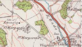
English: Map showing the location of St Margarets Nunnary in relation to Great Gaddesden Herfordshire, England |
| Date | |
| Source | http://www.ponies.me.uk/maps/osmap.html?z=15&x=-2.9419326782226562&y=51.99793477914111 |
| Author | Ordinance Survey, Luton, England and Wales Popular Edition edition. Published in 1932. |
| Permission (Reusing this file) |
Creative Commons Attribution-NonCommercial-ShareAlike 2.0 England & Wales License. |
Licensing
This file is licensed under the Creative Commons Attribution 2.5 Generic license.
- You are free:
- to share – to copy, distribute and transmit the work
- to remix – to adapt the work
- Under the following conditions:
- attribution – You must give appropriate credit, provide a link to the license, and indicate if changes were made. You may do so in any reasonable manner, but not in any way that suggests the licensor endorses you or your use.
File history
Click on a date/time to view the file as it appeared at that time.
| Date/Time | Thumbnail | Dimensions | User | Comment | |
|---|---|---|---|---|---|
| current | 13:10, 17 July 2010 | | 265 × 154 (11 KB) | Lumos3 | {{Information |Description={{en|1=Map showing the location of St Margarets Nunnary in relation to Great gaddesden Herfordshire, England}} |Source=http://www.ponies.me.uk/maps/osmap.html |Author=Ordinance Survey , Luton, England and Wales Popular Edition e |
File usage
The following pages on the English Wikipedia use this file (pages on other projects are not listed):
Global file usage
The following other wikis use this file:
- Usage on www.wikidata.org