
File:Stadtbahn Hannover Netzplan.svg

Size of this PNG preview of this SVG file: 475 × 600 pixels. Other resolutions: 190 × 240 pixels | 380 × 480 pixels | 608 × 768 pixels | 811 × 1,024 pixels | 1,621 × 2,048 pixels | 1,437 × 1,815 pixels.
Original file (SVG file, nominally 1,437 × 1,815 pixels, file size: 15.12 MB)
| This is a file from the Wikimedia Commons. Information from its description page there is shown below. Commons is a freely licensed media file repository. You can help. |
Summary
| Description |
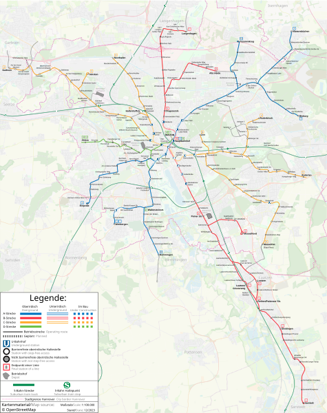
Deutsch: Stadtbahnnetz Hannover |
| Date | |
| Source | openstreetmap.org |
| Author | © Openstreetmap und Mitarbeiter; Bearbeitung: Tobias Zoghaib |
Licensing
| Description |
This map was created from OpenStreetMap project data, collected by the community. This map may be incomplete, and may contain errors. Don't rely solely on it for navigation. |
|||
| Date | (see file history) | |||
| Source | openstreetmap.org | |||
| Creator |
OpenStreetMap contributors |
|||
| Permission (Reusing this file) |
OpenStreetMap data is available under the Open Database License (details). Map tiles are licensed under the Creative Commons Attribution-ShareAlike 2.0 license (CC-BY-SA 2.0).
This file is licensed under the Creative Commons Attribution-Share Alike 2.0 Generic license.
|
|||
| Georeferencing | If inappropriate please set warp_status = skip to hide. |
File history
Click on a date/time to view the file as it appeared at that time.
| Date/Time | Thumbnail | Dimensions | User | Comment | |
|---|---|---|---|---|---|
| current | 23:51, 8 December 2023 | | 1,437 × 1,815 (15.12 MB) | Rescuemod | Liniennetz-Änderungen zum 10.12.23, Linie nach Hemmingen eröffnet |
| 17:49, 8 August 2023 |  | 1,437 × 1,815 (15.12 MB) | Rescuemod | Wendeschleife Linie 2 (Rethen) entfernt, neue Schriftart | |
| 18:30, 20 January 2023 |  | 1,437 × 1,815 (15.12 MB) | PhiH | fehlende Stationsnamen ergänzt, MHH und HCC korrigiert | |
| 01:31, 4 January 2023 |  | 1,437 × 1,815 (15.11 MB) | Rescuemod | Neue barrierefreie Haltestelle "Riechersstraße" | |
| 05:59, 24 November 2022 |  | 1,437 × 1,815 (15.17 MB) | Rescuemod | Neue barrierefreie Haltestellen ergänzt, Legende verbessert | |
| 12:27, 30 March 2022 |  | 1,437 × 1,815 (15.06 MB) | Rescuemod | Geplante MHH-Spange mit Stationen eingezeichnet | |
| 11:46, 28 November 2021 |  | 1,437 × 1,815 (15.06 MB) | Rescuemod | Update December 2021 | |
| 09:05, 6 February 2021 |  | 1,437 × 1,815 (15.17 MB) | Rescuemod | Stationsnamen korrigiert, Stadtgrenze eingezeichnet | |
| 21:52, 26 December 2020 |  | 1,437 × 1,815 (15.16 MB) | Rescuemod | Liniennummern vergrössert und neben die Linien geschrieben | |
| 04:36, 14 December 2020 |  | 1,471 × 1,869 (15.5 MB) | Rescuemod | {{Information |Beschreibung = Stadtbahnnetz Hannover |Quelle = {{own}} |Datum = 2020-12-14 |Quelle = {{OpenStreetMap}} |Urheber = Tobias Zoghaib |Anmerkungen = Kartenmaterial aus OpenStreetMap.org }} |
File usage
The following pages on the English Wikipedia use this file (pages on other projects are not listed):
Global file usage
The following other wikis use this file:
- Usage on de.wikipedia.org
- Usage on eo.wikipedia.org
- Usage on fa.wikipedia.org
- Usage on fr.wikipedia.org
- Usage on it.wikipedia.org
- Usage on nl.wikipedia.org
- Usage on uk.wikipedia.org
- Usage on www.wikidata.org