
File:Stones River Dec31 0945.png
Size of this preview: 480 × 600 pixels. Other resolutions: 192 × 240 pixels | 384 × 480 pixels | 614 × 768 pixels | 819 × 1,024 pixels | 1,638 × 2,048 pixels | 4,800 × 6,000 pixels.
Original file (4,800 × 6,000 pixels, file size: 9.34 MB, MIME type: image/png)
| This is a file from the Wikimedia Commons. Information from its description page there is shown below. Commons is a freely licensed media file repository. You can help. |
Summary
| Description |
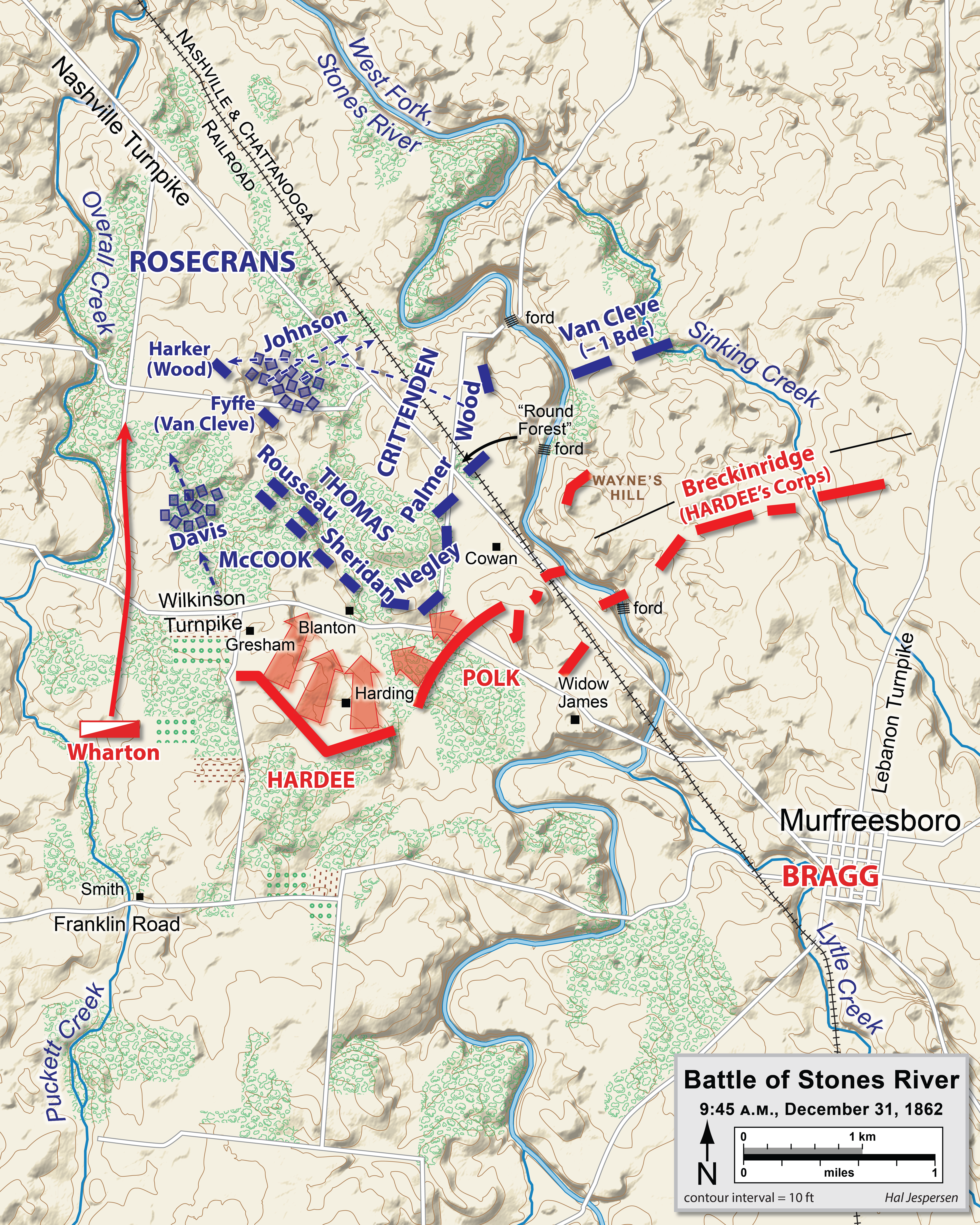
English: Map of the Battle of Stones River of the American Civil War, actions at 09:45, December 31, 1862.
Dansk: Slaget ved Stones River, 31. december 1862, kl. 9.45 |
| Date | |
| Source |
|
| Author | Hal Jespersen |
Licensing
This file is licensed under the Creative Commons Attribution 3.0 Unported license.
Attribution: Map by Hal Jespersen, www.cwmaps.com
- You are free:
- to share – to copy, distribute and transmit the work
- to remix – to adapt the work
- Under the following conditions:
- attribution – You must give appropriate credit, provide a link to the license, and indicate if changes were made. You may do so in any reasonable manner, but not in any way that suggests the licensor endorses you or your use.
Original upload log
The original description page was here. All following user names refer to en.wikipedia.
- 2012-06-28 00:31 Hlj 1469×1250× (529566 bytes) Corrected misspelled name (Breckinridge), miscellaneous minor graphical fixes. Same license.
- 2011-03-31 00:07 Hlj 1469×1250× (506585 bytes) Updated graphical format for rivers and roads. Same license.
- 2010-10-25 22:02 Hlj 1469×1250× (444227 bytes) Update graphics to predominant ACW map style, add legend/scale. Drawn in Adobe Illustrator CS5 by Hal Jespersen. Graphic source file is available at http://www.posix.com/CWmaps/ {{cc-by-3.0|Map by Hal Jespersen, www.posix.com/CW}}
- 2006-03-31 00:53 Hlj 1391×1196× (357649 bytes) Map of the [[Battle of Stones River]] of the [[American Civil War]], actions at 09:45, December 31, 1862. Drawn by Hal Jespersen in Macromedia Freehand. Graphic source file is available at http://www.posix.com/CWmaps/ {{PD-release}}
File history
Click on a date/time to view the file as it appeared at that time.
| Date/Time | Thumbnail | Dimensions | User | Comment | |
|---|---|---|---|---|---|
| current | 21:15, 5 January 2023 | | 4,800 × 6,000 (9.34 MB) | Hlj | improved graphics |
| 22:52, 10 September 2012 |  | 1,469 × 1,250 (517 KB) | OgreBot | (BOT): Uploading old version of file from en.wikipedia; originally uploaded on 2012-06-28 00:31:57 by Hlj | |
| 22:52, 10 September 2012 |  | 1,469 × 1,250 (495 KB) | OgreBot | (BOT): Uploading old version of file from en.wikipedia; originally uploaded on 2011-03-31 00:07:44 by Hlj | |
| 22:52, 10 September 2012 |  | 1,469 × 1,250 (434 KB) | OgreBot | (BOT): Uploading old version of file from en.wikipedia; originally uploaded on 2010-10-25 22:02:03 by Hlj | |
| 22:52, 10 September 2012 |  | 1,391 × 1,196 (349 KB) | OgreBot | (BOT): Uploading old version of file from en.wikipedia; originally uploaded on 2006-03-31 00:53:39 by Hlj | |
| 11:57, 11 August 2008 |  | 697 × 599 (272 KB) | Nis Hoff | {{Information |Description={{en|1=(Map of the Battle of Stones River of the American Civil War, actions at 09:45, December 31, 1862. Drawn by Hal Jespersen in Macromedia Freehand. Graphic source file is available at http://www.posix.com/CWmaps/ {{PD-relea |
File usage
The following pages on the English Wikipedia use this file (pages on other projects are not listed):
Global file usage
The following other wikis use this file:
- Usage on da.wikipedia.org
- Usage on ja.wikipedia.org
- Usage on nl.wikipedia.org
- Usage on no.wikipedia.org
- Usage on pl.wikipedia.org