File:Swine Flu Florida2.PNG
Appearance
Swine_Flu_Florida2.PNG (491 × 464 pixels, file size: 14 KB, MIME type: image/png)
File history
Click on a date/time to view the file as it appeared at that time.
| Date/Time | Thumbnail | Dimensions | User | Comment | |
|---|---|---|---|---|---|
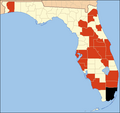
| current | 19:39, 19 June 2009 |  | 491 × 464 (14 KB) | Phizzy | Death in Miami-Dade. |
| 13:38, 21 May 2009 |  | 491 × 464 (9 KB) | Dimitriosolivieri | adding Santa Rosa County, removing Okaloosa | |
| 17:48, 18 May 2009 |  | 491 × 464 (9 KB) | Dimitriosolivieri | added Polk County | |
| 15:19, 15 May 2009 |  | 491 × 464 (9 KB) | Dimitriosolivieri | {{Information |Description={{en|1=A map of swine flu cases in Florida.}} |Source=http://commons.wikimedia.org/wiki/File:Florida_Locator_Map.PNG |Author=US Census |Date= |Permission= |other_versions= }} <!--{{ImageUpload|full}}--> |
File usage
The following 3 pages use this file:

