
File:The Town Hall, Market Place, Tamworth - geograph.org.uk - 1741283.jpg
No higher resolution available.
The_Town_Hall,_Market_Place,_Tamworth_-_geograph.org.uk_-_1741283.jpg (750 × 563 pixels, file size: 334 KB, MIME type: image/jpeg)
| This is a file from the Wikimedia Commons. Information from its description page there is shown below. Commons is a freely licensed media file repository. You can help. |
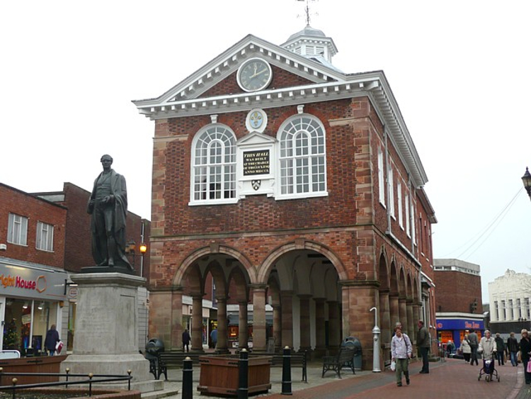
This is a photo of listed building number 1293012. |
Summary
| Description |
English: The Town Hall, Market Place, Tamworth Built in 1701 by Thomas Guy, M.P. for the town. It is of mellow brick with arcades at ground level, large Jacobean windows and a steeply-pitched roof topped by a cupola. (The Shell Guide to England, 1970) It once housed the Butter Market and was used to store the towns fire engine. The rear was added in the 19th century. The Tourist Information Centre is located next to it. In front is the bronze statue of Sir Robert Peel, dating from 1852. Former Tamworth MP and twice Prime Minister, Sir Robert delivered his famous Tamworth Manifesto from the window of the Town Hall in 1834. (From the Heritage Trail leaflet) http://www.tamworth.gov.uk/PDF/heritage_trail2.pdf |
| Date | |
| Source | From geograph.org.uk |
| Author | Humphrey Bolton |
| Attribution (required by the license) | Humphrey Bolton / The Town Hall, Market Place, Tamworth / |
| Camera location | | View this and other nearby images on: OpenStreetMap |
|---|
_heading:90.00&language=en)
| Object location | | View this and other nearby images on: OpenStreetMap |
|---|
_heading:90.00&language=en)
Licensing

|
This image was taken from the Geograph project collection. See this photograph's page on the Geograph website for the photographer's contact details. The copyright on this image is owned by Humphrey Bolton and is licensed for reuse under the Creative Commons Attribution-ShareAlike 2.0 license.
|
This file is licensed under the Creative Commons Attribution-Share Alike 2.0 Generic license.
Attribution: Humphrey Bolton
- You are free:
- to share – to copy, distribute and transmit the work
- to remix – to adapt the work
- Under the following conditions:
- attribution – You must give appropriate credit, provide a link to the license, and indicate if changes were made. You may do so in any reasonable manner, but not in any way that suggests the licensor endorses you or your use.
- share alike – If you remix, transform, or build upon the material, you must distribute your contributions under the same or compatible license as the original.
File history
Click on a date/time to view the file as it appeared at that time.
| Date/Time | Thumbnail | Dimensions | User | Comment | |
|---|---|---|---|---|---|
| current | 17:44, 11 February 2021 | | 750 × 563 (334 KB) | G-13114 | Tweak sizing |
| 20:32, 5 March 2011 |  | 640 × 480 (101 KB) | GeographBot | == {{int:filedesc}} == {{Information |description={{en|1=The Town Hall, Market Place, Tamworth Built in 1701 by Thomas Guy, M.P. for the town. It is of mellow brick with arcades at ground level, large Jacobean windows and a steeply-pitched roof topped by |
File usage
The following pages on the English Wikipedia use this file (pages on other projects are not listed):
Global file usage
The following other wikis use this file:
- Usage on pl.wikipedia.org