
File:The Village Pound - geograph.org.uk - 1533684.jpg
The_Village_Pound_-_geograph.org.uk_-_1533684.jpg (640 × 480 pixels, file size: 112 KB, MIME type: image/jpeg)
| This is a file from the Wikimedia Commons. Information from its description page there is shown below. Commons is a freely licensed media file repository. You can help. |
Summary
| Description |
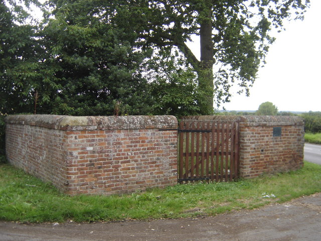
English: The Village Pound, North Elmham, Norfolk. The most common use was to hold stray animals, cattle, sheep, pigs, etc. They were driven into the pound and kept there at the expense of the owner, until such time as he paid the fine, the amount claimed by the 'impounder' (the person onto whose land they had strayed on) for the damage done and the fee to the pound keeper, for feeding and watering them.
If not claimed within three weeks, the animals were driven to the nearest market and sold, the proceeds going to the impounder and the pound-keeper. A clever form of receipt was sometimes used. The person who found the animals on his land cut a stick and made notches, one for every beast, and then split the stick down the centre of the notches so that half of each notch appeared on each stick; one half he kept, the other he gave to the pound-keeper. When the owner came to redeem his animals and had paid for the damage done, the impounder gave him his half stick. He took this to the pound-keeper, and if the two pieces tallied, it proved he had paid, and his beasts were freed. Hence the word 'Tally-stick' and the pound-keeper being referred to as 'The Tallyman'. |
| Date | |
| Source | From geograph.org.uk |
| Author | John Wernham |
| Attribution (required by the license) | John Wernham / The Village Pound / |
| Camera location | | View this and other nearby images on: OpenStreetMap |
|---|
_heading:315.00&language=en)
| Object location | | View this and other nearby images on: OpenStreetMap |
|---|
_heading:315.00&language=en)
Licensing

|
This image was taken from the Geograph project collection. See this photograph's page on the Geograph website for the photographer's contact details. The copyright on this image is owned by John Wernham and is licensed for reuse under the Creative Commons Attribution-ShareAlike 2.0 license.
|
- You are free:
- to share – to copy, distribute and transmit the work
- to remix – to adapt the work
- Under the following conditions:
- attribution – You must give appropriate credit, provide a link to the license, and indicate if changes were made. You may do so in any reasonable manner, but not in any way that suggests the licensor endorses you or your use.
- share alike – If you remix, transform, or build upon the material, you must distribute your contributions under the same or compatible license as the original.
File history
Click on a date/time to view the file as it appeared at that time.
| Date/Time | Thumbnail | Dimensions | User | Comment | |
|---|---|---|---|---|---|
| current | 07:52, 3 March 2011 | | 640 × 480 (112 KB) | GeographBot | == {{int:filedesc}} == {{Information |description={{en|1=The Village Pound The most common use was to hold stray animals, cattle, sheep, pigs, etc. They were driven into the pound and kept there at the expense of the owner, until such time as he pai |
File usage
Global file usage
The following other wikis use this file: