
File:The ruined church of St Mary in Tilney cum Islington - geograph.org.uk - 1820224.jpg
No higher resolution available.
The_ruined_church_of_St_Mary_in_Tilney_cum_Islington_-_geograph.org.uk_-_1820224.jpg (640 × 480 pixels, file size: 115 KB, MIME type: image/jpeg)
| This is a file from the Wikimedia Commons. Information from its description page there is shown below. Commons is a freely licensed media file repository. You can help. |
Summary
| Description |
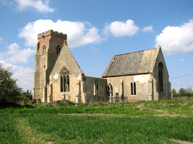
English: The ruined church of St Mary in Tilney cum Islington, near to Tilney High End, Norfolk, Great Britain.
This cruciform church dates from the 13th century, with its tower built in the 15th and the north porch added in the 16th century. After years of disuse and neglect the nave and transept roofs eventually collapsed. When the church was formally declared redundant in 1973 it passed into the care of the Redundant Churches Fund. The chancel > <a title="https://www.geograph.org.uk/photo/1820245" rel="nofollow" href="https://www.geograph.org.uk/photo/1820245">Link</a><img style="padding-left:2px;" alt="External link" title="External link - shift click to open in new window" src="http://s0.geograph.org.uk/img/external.png" width="10" height="10"/> has since been made safe and 18th and 19th century memorials to the Dixon and Bagge families - Lords of the Manor - were moved to there from other parts of the building for their protection. |
| Date | |
| Source | From geograph.org.uk; transferred by User:Peter I. Vardy using geograph_org2commons. |
| Author | Evelyn Simak |
| Permission (Reusing this file) |
Creative Commons Attribution Share-alike license 2.0 |
| Attribution (required by the license) | Evelyn Simak / The ruined church of St Mary in Tilney cum Islington / |
| Camera location | | View this and other nearby images on: OpenStreetMap |
|---|
| Object location | | View this and other nearby images on: OpenStreetMap |
|---|
_region:GB-GBN_heading:315.00&language=en)
Licensing

|
This image was taken from the Geograph project collection. See this photograph's page on the Geograph website for the photographer's contact details. The copyright on this image is owned by Evelyn Simak and is licensed for reuse under the Creative Commons Attribution-ShareAlike 2.0 license.
|
This file is licensed under the Creative Commons Attribution-Share Alike 2.0 Generic license.
Attribution: Evelyn Simak
- You are free:
- to share – to copy, distribute and transmit the work
- to remix – to adapt the work
- Under the following conditions:
- attribution – You must give appropriate credit, provide a link to the license, and indicate if changes were made. You may do so in any reasonable manner, but not in any way that suggests the licensor endorses you or your use.
- share alike – If you remix, transform, or build upon the material, you must distribute your contributions under the same or compatible license as the original.
File history
Click on a date/time to view the file as it appeared at that time.
| Date/Time | Thumbnail | Dimensions | User | Comment | |
|---|---|---|---|---|---|
| current | 15:48, 12 February 2011 | | 640 × 480 (115 KB) | File Upload Bot (Magnus Manske) |
File usage
The following pages on the English Wikipedia use this file (pages on other projects are not listed):
Global file usage
The following other wikis use this file:
- Usage on ru.wikipedia.org
- Usage on www.wikidata.org