
File:The ruins of St Mary's Priory - geograph.org.uk - 790316.jpg
Size of this preview: 450 × 600 pixels. Other resolutions: 180 × 240 pixels | 480 × 640 pixels.
Original file (480 × 640 pixels, file size: 175 KB, MIME type: image/jpeg)
| This is a file from the Wikimedia Commons. Information from its description page there is shown below. Commons is a freely licensed media file repository. You can help. |
Summary
| Description |
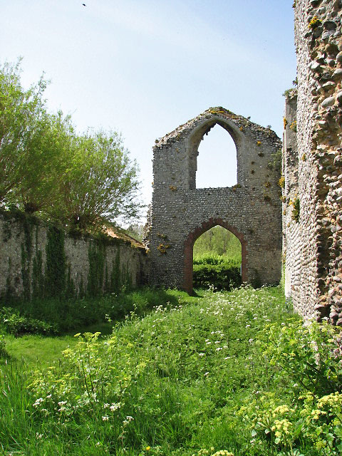
English: The ruins of St Mary's Priory View west along what used to be the nave, from the former crossing.
Believed to have been founded by Margaret Cressey in 1216 for a small community numbering two to six Augustine canons (ordained priests who lived according to the rules of St Augustine and served as parish priests for nearby churches). In all probability the adjoining land was farmed by monks; the precinct consisted of agricultural buildings, brewery, guest house, wash house, latrines and probably a smithy. The priory was dissolved in 1539. Its church survived because it was converted into farm buildings. Presently owned by the Norfolk Historic Buildings Trust and in the guardianship of the Norfolk County Council, the ruin is accessible via a public footpath > https://www.geograph.org.uk/photo/790304. Entering through the main west entrance, one steps into the nave with a side chapel to the north; the church was of a cruciform shape and the crossing (underneath the tower) was located at the eastern end of the nave. There used to be a north and a south transept, and a chapter house adjacent to the latter. The east end was formed by the presbytery, there was another chapel east of the north transept. |
| Date | Taken on 5 May 2008 |
| Source | From geograph.org.uk |
| Author | Evelyn Simak |
| Other versions |
|
| Attribution (required by the license) | Evelyn Simak / The ruins of St Mary's Priory / |
.JPG)


| Camera location | | View this and other nearby images on: OpenStreetMap |
|---|
_heading:270.00&language=en)
| Object location | | View this and other nearby images on: OpenStreetMap |
|---|
_heading:270.00&language=en)
Licensing

|
This image was taken from the Geograph project collection. See this photograph's page on the Geograph website for the photographer's contact details. The copyright on this image is owned by Evelyn Simak and is licensed for reuse under the Creative Commons Attribution-ShareAlike 2.0 license.
|
This file is licensed under the Creative Commons Attribution-Share Alike 2.0 Generic license.
Attribution: Evelyn Simak
- You are free:
- to share – to copy, distribute and transmit the work
- to remix – to adapt the work
- Under the following conditions:
- attribution – You must give appropriate credit, provide a link to the license, and indicate if changes were made. You may do so in any reasonable manner, but not in any way that suggests the licensor endorses you or your use.
- share alike – If you remix, transform, or build upon the material, you must distribute your contributions under the same or compatible license as the original.
File history
Click on a date/time to view the file as it appeared at that time.
| Date/Time | Thumbnail | Dimensions | User | Comment | |
|---|---|---|---|---|---|
| current | 06:20, 20 February 2011 | | 480 × 640 (175 KB) | GeographBot | == {{int:filedesc}} == {{Information |description={{en|1=The ruins of St Mary's Priory View west along what used to be the nave, from the former crossing. Believed to have been founded by Margaret Cressey in 1216 for a small community numbering two to |
File usage
The following pages on the English Wikipedia use this file (pages on other projects are not listed):
Global file usage
The following other wikis use this file:
- Usage on www.wikidata.org