
File:Topographic map of Zanzibar-en.svg

Size of this PNG preview of this SVG file: 416 × 599 pixels. Other resolutions: 166 × 240 pixels | 333 × 480 pixels | 533 × 768 pixels | 711 × 1,024 pixels | 1,422 × 2,048 pixels | 420 × 605 pixels.
Original file (SVG file, nominally 420 × 605 pixels, file size: 409 KB)
| This is a file from the Wikimedia Commons. Information from its description page there is shown below. Commons is a freely licensed media file repository. You can help. |
This W3C-unspecified vector image was created with Inkscape .
Summary
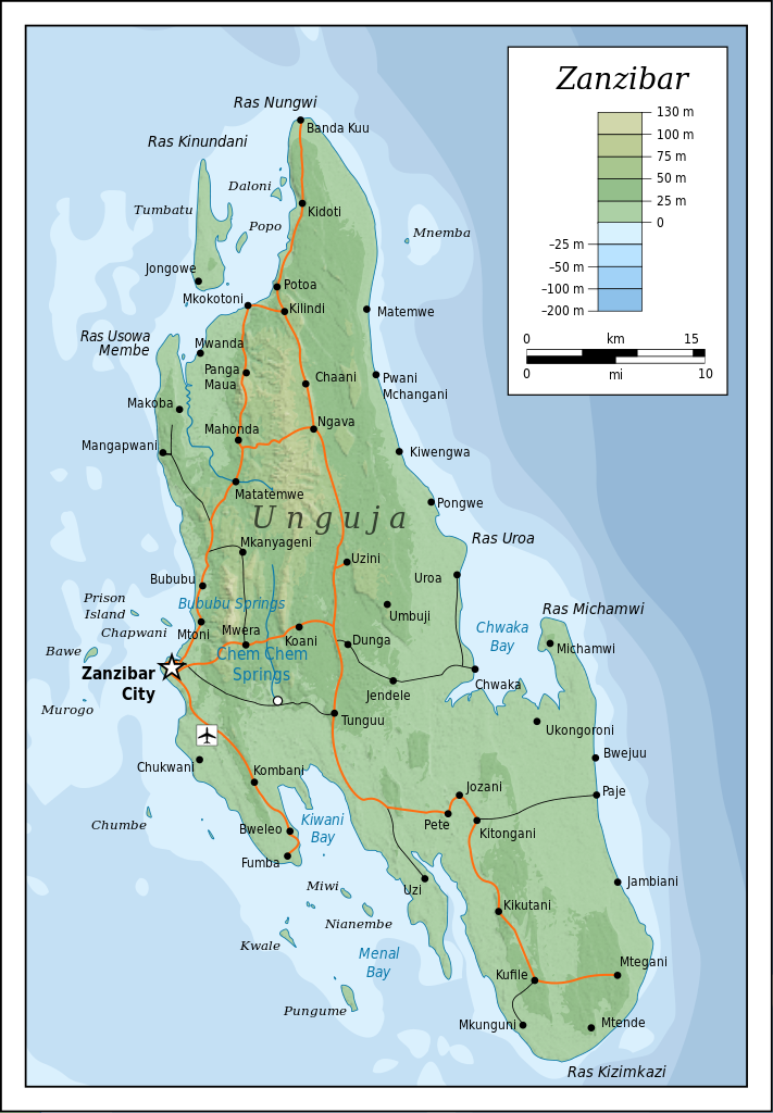
| Description |
|
| Date | |
| Source |
Self-made in Inkscape (renamed from Image:Topographic map of Zanzibar.svg). Roads, rivers and place names based on a public domain 1976 CIA map (from http://www.lib.utexas.edu/maps/tanzania.html) with some updates applied. Topography based on public domain SRTM data from NASA. Bathymetry per http://www.theissresearch.org/zanzibar/. |
| Author | Mysid |
| Other versions |
[]
|


|
This SVG file contains embedded text that can be translated into your language, using any capable SVG editor, text editor or the SVG Translate tool. For more information see: About translating SVG files. |
Licensing
I, the copyright holder of this work, hereby publish it under the following licenses:

|
Permission is granted to copy, distribute and/or modify this document under the terms of the GNU Free Documentation License, Version 1.2 or any later version published by the Free Software Foundation; with no Invariant Sections, no Front-Cover Texts, and no Back-Cover Texts. A copy of the license is included in the section entitled GNU Free Documentation License. |
This file is licensed under the Creative Commons Attribution-Share Alike 4.0 International, 3.0 Unported, 2.5 Generic, 2.0 Generic and 1.0 Generic license.
- You are free:
- to share – to copy, distribute and transmit the work
- to remix – to adapt the work
- Under the following conditions:
- attribution – You must give appropriate credit, provide a link to the license, and indicate if changes were made. You may do so in any reasonable manner, but not in any way that suggests the licensor endorses you or your use.
- share alike – If you remix, transform, or build upon the material, you must distribute your contributions under the same or compatible license as the original.
You may select the license of your choice.
File history
Click on a date/time to view the file as it appeared at that time.
| Date/Time | Thumbnail | Dimensions | User | Comment | |
|---|---|---|---|---|---|
| current | 20:52, 20 July 2010 | | 420 × 605 (409 KB) | Mysid | cropping fail! |
| 20:50, 20 July 2010 |  | 429 × 630 (409 KB) | Mysid | revised with relief shading and higher-grain topography | |
| 11:01, 19 April 2008 |  | 400 × 601 (61 KB) | Bibi Saint-Pol | {{inkscape}} == {{int:filedesc}} == {{Information |Description= {{en|Topographic map of Zanzibar, Tanzania.}} {{fi|Sansibarin (Tansania) topografinen kartta.}} |Source=Self-made in Inkscape.<br/>Boundaries based on a public domain 1976 CIA map (from http: |
File usage
The following pages on the English Wikipedia use this file (pages on other projects are not listed):
Global file usage
The following other wikis use this file:
- Usage on af.wikipedia.org
- Usage on ar.wikipedia.org
- Usage on bg.wikipedia.org
- Usage on ca.wikipedia.org
- Usage on ceb.wikipedia.org
- Usage on cs.wikipedia.org
- Usage on cy.wikipedia.org
- Usage on da.wikipedia.org
- Usage on de.wikipedia.org
- Usage on de.wikivoyage.org
- Usage on el.wikipedia.org
- Usage on eo.wikipedia.org
- Usage on es.wikipedia.org
- Usage on eu.wikipedia.org
- Usage on fr.wikipedia.org
- Usage on fy.wikipedia.org
- Usage on gl.wikipedia.org
- Usage on he.wikipedia.org
- Usage on hr.wikipedia.org
- Usage on hy.wikipedia.org
- Usage on id.wikipedia.org
- Usage on it.wikivoyage.org
- Usage on ko.wikipedia.org
- Usage on lt.wikipedia.org
- Usage on mrj.wikipedia.org
- Usage on nl.wikipedia.org
- Usage on no.wikipedia.org
- Usage on pl.wikipedia.org
- Usage on pl.wiktionary.org
- Usage on ru.wikipedia.org
- Usage on sh.wikipedia.org
- Usage on sn.wikipedia.org
- Usage on sq.wikipedia.org
- Usage on sv.wikipedia.org
- Usage on uk.wikipedia.org
- Usage on ur.wikipedia.org
- Usage on vi.wikipedia.org
View more global usage of this file.