
File:Tour de France 1939.png
No higher resolution available.
Tour_de_France_1939.png (599 × 599 pixels, file size: 342 KB, MIME type: image/png)
| This is a file from the Wikimedia Commons. Information from its description page there is shown below. Commons is a freely licensed media file repository. You can help. |
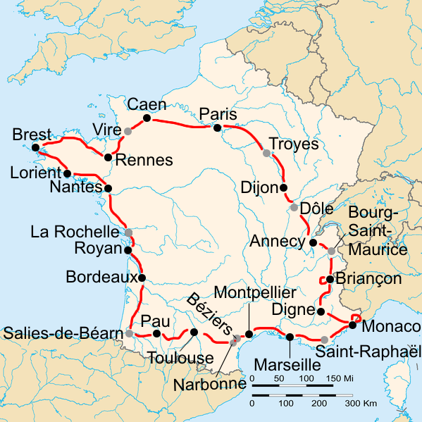
How I made this map: I started with France_blank.png. Then I looked at the Tour schedule, and placed a 100% black circle, radius 11px, on all the cities where a stage started/ended, and a 40% black circle, radius 11px, on all the cities where a split stage started/ended. Then I connected these cities by red lines, 3px thickness, drawn by hand. I then added the city names in 100% black, Arial 24pt.
| Description | Route of the 1939 Tour de France, starting and finishing in Paris. The black dots are the cities that hosted a stage start and finish, the grey dots are the cities where a split stage was split. |
| Date | |
| Source | |
| Author |
|
I, the copyright holder of this work, hereby publish it under the following licenses:
This file is licensed under the Creative Commons Attribution-Share Alike 2.0 Generic license.
- You are free:
- to share – to copy, distribute and transmit the work
- to remix – to adapt the work
- Under the following conditions:
- attribution – You must give appropriate credit, provide a link to the license, and indicate if changes were made. You may do so in any reasonable manner, but not in any way that suggests the licensor endorses you or your use.
- share alike – If you remix, transform, or build upon the material, you must distribute your contributions under the same or compatible license as the original.
This file is licensed under the Creative Commons Attribution-Share Alike 2.0 France license.
- You are free:
- to share – to copy, distribute and transmit the work
- to remix – to adapt the work
- Under the following conditions:
- attribution – You must give appropriate credit, provide a link to the license, and indicate if changes were made. You may do so in any reasonable manner, but not in any way that suggests the licensor endorses you or your use.
- share alike – If you remix, transform, or build upon the material, you must distribute your contributions under the same or compatible license as the original.

| This file is licensed under the Creative Commons Attribution-Share Alike 3.0 Unported license. | ||
| ||
| This licensing tag was added to this file as part of the GFDL licensing update. |

|
Permission is granted to copy, distribute and/or modify this document under the terms of the GNU Free Documentation License, Version 1.2 or any later version published by the Free Software Foundation; with no Invariant Sections, no Front-Cover Texts, and no Back-Cover Texts. A copy of the license is included in the section entitled GNU Free Documentation License. |
You may select the license of your choice.
Original upload log
This image is a derivative work of the following images:
- File:France_blank.png licensed with Cc-by-sa-2.0, Cc-by-sa-2.0-fr, Cc-by-sa-3.0-migrated, GFDL
- 2006-02-24T05:46:14Z Sting 1795x1796 (158534 Bytes) Colour correction for the seas
- 2006-02-20T20:56:02Z Sting 1795x1796 (158397 Bytes) '''en :''' '''Subject :''' Blank map of France ; '''Source :''' [[:Image:France_cities.png]] made by [[User:David.Monniaux|David Monniaux]] ; '''This version :''' By [[User:Sting|Sting]]. ---- '''fr :''' '''Sujet :''' Ca
Uploaded with derivativeFX
File history
Click on a date/time to view the file as it appeared at that time.
| Date/Time | Thumbnail | Dimensions | User | Comment | |
|---|---|---|---|---|---|
| current | 16:16, 18 January 2010 | | 599 × 599 (342 KB) | EdgeNavidad | {{Information |Description=Route of the 1939 Tour de France, starting and finishing in Paris. The black dots are the cities that hosted a stage start and finish, the grey dots are the cities where a split stage was split. |Source=*[[:File:France_blank.png |
File usage
The following pages on the English Wikipedia use this file (pages on other projects are not listed):
Global file usage
The following other wikis use this file:
- Usage on ar.wikipedia.org
- Usage on ast.wikipedia.org
- Usage on ca.wikipedia.org
- Usage on cs.wikipedia.org
- Usage on de.wikipedia.org
- Usage on es.wikipedia.org
- Usage on eu.wikipedia.org
- Usage on fr.wikipedia.org
- Usage on hu.wikipedia.org
- Usage on it.wikipedia.org
- Usage on nl.wikipedia.org
- Usage on no.wikipedia.org
- Usage on pl.wikipedia.org
- Usage on pt.wikipedia.org
- Usage on www.wikidata.org