
File:United Nations member countries world map.PNG

Size of this preview: 800 × 338 pixels. Other resolutions: 320 × 135 pixels | 640 × 270 pixels | 1,480 × 625 pixels.
Original file (1,480 × 625 pixels, file size: 73 KB, MIME type: image/png)
| This is a file from the Wikimedia Commons. Information from its description page there is shown below. Commons is a freely licensed media file repository. You can help. |

|
File:UN Member Countries World.svg is a vector version of this file. It should be used in place of this PNG file when not inferior.
File:United Nations member countries world map.PNG → File:UN Member Countries World.svg
For more information, see Help:SVG. |
 |
Summary
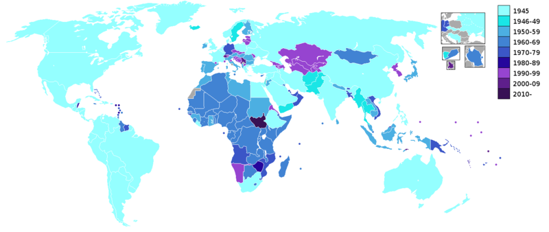
| Description | At the top right is an inset map showing Cold War countries - USSR, Yugoslavia, Czechoslovakia, East Germany and West Germany. Also shown are North Yemen and South Yemen, and Tanganyika and Zanzibar. Note: On the site, Russia, Belarus and Ukraine are given a 1945 date for joining, with the other former-Soviet republics given a 1990s date. China is given a 1945 date for joining, when they were represented by the Republic of China (which later relocated to Taiwan in 1949), and was replaced by the People's Republic of China as China's representative in 1971 (see China and the United Nations). All areas listed in gray are not UN members. |
| Source | Map showing United Nations members and the decade they joined the UN as from the figures on the UN site. |
| Author | Roke |
|
|
File:UN Member Countries World.svg is a vector version of this file. It should be used in place of this PNG file when not inferior.
File:United Nations member countries world map.PNG → File:UN Member Countries World.svg
For more information, see Help:SVG. |
|
.
Licensing
I, the copyright holder of this work, hereby publish it under the following licenses:

|
Permission is granted to copy, distribute and/or modify this document under the terms of the GNU Free Documentation License, Version 1.2 or any later version published by the Free Software Foundation; with no Invariant Sections, no Front-Cover Texts, and no Back-Cover Texts. A copy of the license is included in the section entitled GNU Free Documentation License. |
| This file is licensed under the Creative Commons Attribution-Share Alike 3.0 Unported license. | ||
| ||
| This licensing tag was added to this file as part of the GFDL licensing update. |
You may select the license of your choice.
File history
Click on a date/time to view the file as it appeared at that time.
| Date/Time | Thumbnail | Dimensions | User | Comment | |
|---|---|---|---|---|---|
| current | 04:23, 10 July 2011 | | 1,480 × 625 (73 KB) | Spesh531 | update |
| 04:19, 10 July 2011 |  | 1,480 × 625 (73 KB) | Spesh531 | adding south sudan | |
| 21:11, 12 June 2007 |  | 1,438 × 631 (42 KB) | Mandavi | fixed the rather ugly script to interlaced | |
| 21:52, 17 May 2007 |  | 1,438 × 631 (36 KB) | Chanheigeorge | better version | |
| 21:40, 17 May 2007 |  | 1,438 × 631 (35 KB) | Chanheigeorge | graying surrounding countries in box | |
| 19:47, 16 May 2007 |  | 1,438 × 631 (35 KB) | Chanheigeorge | Add a box for Tanganyika and Zanzibar | |
| 15:16, 23 January 2007 |  | 1,438 × 631 (38 KB) | Roke~commonswiki | cosmetic - overlay with layer to remove lines | |
| 04:37, 5 December 2006 |  | 1,438 × 631 (35 KB) | Chanheigeorge | better version for Malaysia | |
| 03:11, 25 November 2006 |  | 1,438 × 631 (35 KB) | Chanheigeorge | Fix Malaysia | |
| 23:33, 20 September 2006 |  | 1,438 × 631 (54 KB) | Hoshie | I have corrected the boundry between the YAR and PDRY. The boundry then was unsettled. See this 1976 map: http://www.lib.utexas.edu/maps/middle_east_and_asia/middle_east_pol_1976.jpg |
File usage
The following pages on the English Wikipedia use this file (pages on other projects are not listed):
Global file usage
The following other wikis use this file:
- Usage on af.wikipedia.org
- Usage on ar.wikipedia.org
- Usage on bg.wikipedia.org
- Usage on bn.wikipedia.org
- Usage on bs.wikipedia.org
- Usage on ca.wikipedia.org
- Usage on ckb.wikipedia.org
- Usage on de.wikipedia.org
- Usage on es.wikipedia.org
- Usage on fa.wikipedia.org
- Usage on fi.wikipedia.org
- Usage on fr.wikipedia.org
- Usage on he.wikipedia.org
- Usage on hi.wikipedia.org
- Usage on hy.wikipedia.org
- Usage on id.wikipedia.org
- Usage on ja.wikipedia.org
- Usage on ko.wikipedia.org
- Usage on mk.wikipedia.org
- Usage on nl.wikipedia.org
- Usage on no.wikipedia.org
- Usage on pl.wikipedia.org
- Usage on pt.wikipedia.org
- Usage on ro.wikipedia.org
- Usage on sh.wikipedia.org
- Usage on so.wikipedia.org
- Usage on sr.wikipedia.org
- Usage on te.wikipedia.org
- Usage on th.wikipedia.org
- Usage on vi.wikipedia.org
- Usage on www.wikidata.org