
File:VASR 7 map.svg

Size of this PNG preview of this SVG file: 800 × 585 pixels. Other resolutions: 320 × 234 pixels | 640 × 468 pixels | 1,024 × 749 pixels | 1,280 × 937 pixels | 2,560 × 1,873 pixels | 846 × 619 pixels.
Original file (SVG file, nominally 846 × 619 pixels, file size: 282 KB)
| This is a file from the Wikimedia Commons. Information from its description page there is shown below. Commons is a freely licensed media file repository. You can help. |
Summary
| Description |
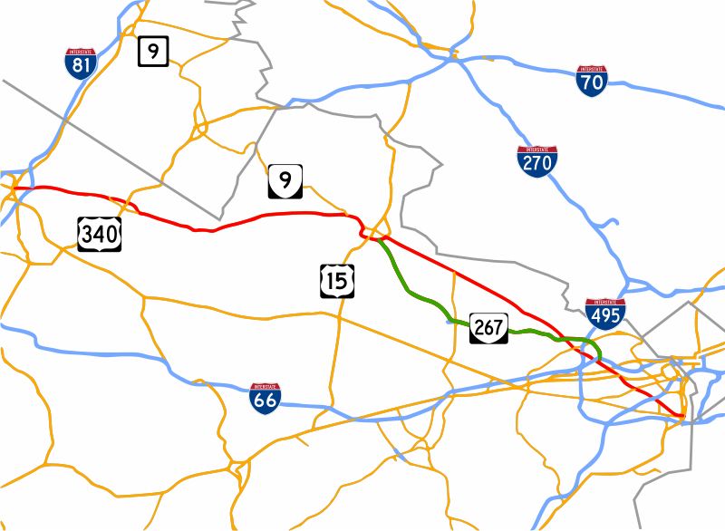
English: Map of w:Virginia State Route 7. This map the following data: U.S. Census Bureau Cartographic Boundary Files for county boundaries, and National Highway Planning Network Data for roads. |
| Date | |
| Source | Own work |
| Author | Xenon54 |
This W3C-unspecified vector image was created with Inkscape .
Licensing
I, the copyright holder of this work, hereby publish it under the following license:
This file is licensed under the Creative Commons Attribution-Share Alike 3.0 Unported license.
- You are free:
- to share – to copy, distribute and transmit the work
- to remix – to adapt the work
- Under the following conditions:
- attribution – You must give appropriate credit, provide a link to the license, and indicate if changes were made. You may do so in any reasonable manner, but not in any way that suggests the licensor endorses you or your use.
- share alike – If you remix, transform, or build upon the material, you must distribute your contributions under the same or compatible license as the original.
File history
Click on a date/time to view the file as it appeared at that time.
| Date/Time | Thumbnail | Dimensions | User | Comment | |
|---|---|---|---|---|---|
| current | 23:12, 13 January 2009 | | 846 × 619 (282 KB) | Xenon54 | non-smoothed lines |
| 02:57, 3 January 2009 |  | 846 × 619 (509 KB) | Xenon54 | One more one more attempt | |
| 02:45, 3 January 2009 |  | 846 × 619 (488 KB) | Xenon54 | One more attempt | |
| 18:27, 2 January 2009 |  | 846 × 619 (487 KB) | Xenon54 | bad upload again, trying a 3rd time | |
| 18:20, 2 January 2009 |  | 846 × 619 (76 KB) | Xenon54 | bad upload, trying again | |
| 18:16, 2 January 2009 |  | 846 × 619 (75 KB) | Xenon54 | {{Information |Description={{en|1=Map of w:Virginia State Route 7. This map the following data: [http://www.census.gov/geo/www/cob/bdy_files.html U.S. Census Bureau Cartographic Boundary Files] for county boundaries, and [http://www.fhwa.dot.gov/plann |
File usage
No pages on the English Wikipedia use this file (pages on other projects are not listed).