
File:Vic-m-verulam.jpg

Size of this preview: 401 × 600 pixels. Other resolutions: 160 × 240 pixels | 553 × 827 pixels.
Original file (553 × 827 pixels, file size: 205 KB, MIME type: image/jpeg)
| This is a file from the Wikimedia Commons. Information from its description page there is shown below. Commons is a freely licensed media file repository. You can help. |
Summary
| Description |
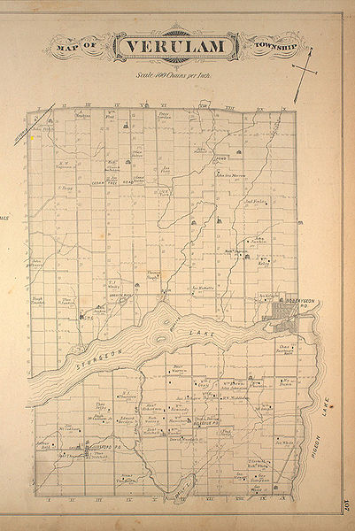
English: 1881 map of Verulam Township in Victoria County, Province of Ontario, Canada. |
| Date | |
| Source |
Originally published in Victoria Supplement in Illustrated atlas of the Dominion of Canada (Toronto : H. Belden & Co., 1881). Retrieved from McGill University Digital Map Project - Rare Books & Special Collections, McGill University Library Verulam Township |
| Author | H. Belden & Co. |
Licensing
This work is an Ordnance Survey map over 50 years old, which is covered by Crown Copyright which in this case expires 50 years after publication. Ordnance Survey does however ask that they be credited and that the date of publication be given.
Any ancillary rights gained through the creation of the electronic version are granted as freely usable under any circumstances.
|
This work created by the United Kingdom Government is in the public domain.
This is because it is one of the following:
HMSO has declared that the expiry of Crown Copyrights applies worldwide (ref: HMSO Email Reply)
|
 |
Original upload log
The original description page was here. All following user names refer to en.wikipedia.
- 2007-04-30 19:27 Cli0019 553×827× (209998 bytes) McGill University Digital Map Project http://digital.library.mcgill.ca/countyatlas/showtownship2.php?townshipid=Verulam
File history
Click on a date/time to view the file as it appeared at that time.
| Date/Time | Thumbnail | Dimensions | User | Comment | |
|---|---|---|---|---|---|
| current | 00:00, 6 October 2009 | | 553 × 827 (205 KB) | File Upload Bot (Magnus Manske) | {{BotMoveToCommons|en.wikipedia|year={{subst:CURRENTYEAR}}|month={{subst:CURRENTMONTHNAME}}|day={{subst:CURRENTDAY}}}} {{Information |Description={{en|McGill University Digital Map Project http://digital.library.mcgill.ca/countyatlas/showtownship2.php?to |
File usage
The following pages on the English Wikipedia use this file (pages on other projects are not listed):