
File:Vojvodina politics03.png

Size of this preview: 462 × 599 pixels. Other resolutions: 185 × 240 pixels | 370 × 480 pixels | 760 × 986 pixels.
Original file (760 × 986 pixels, file size: 190 KB, MIME type: image/png)
| This is a file from the Wikimedia Commons. Information from its description page there is shown below. Commons is a freely licensed media file repository. You can help. |
Summary
| Description |
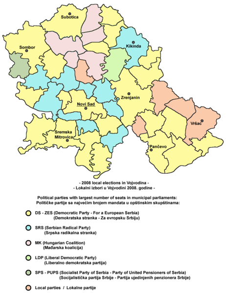
English: Election map of Vojvodina from 2008 - results of local elections.
Српски / srpski: Izborna mapa Vojvodine iz 2008. godine - rezultati lokalnih izbora. |
| Date | 12 February 2009 (original upload date) |
| Source | Own work |
| Author | PANONIAN |
Licensing
| I, the copyright holder of this work, release this work into the public domain. This applies worldwide. In some countries this may not be legally possible; if so: I grant anyone the right to use this work for any purpose, without any conditions, unless such conditions are required by law. |
References
Made according to the data from these sources:
- http://www.cesid.org/
- http://webrzs.stat.gov.rs/WebSite/repository/documents/00/00/19/85/Lokalni_izbori_2008.pdf
File history
Click on a date/time to view the file as it appeared at that time.
| Date/Time | Thumbnail | Dimensions | User | Comment | |
|---|---|---|---|---|---|
| current | 20:40, 10 April 2010 | | 760 × 986 (190 KB) | PANONIAN | improved version - better aesthetics and corrected data in Temerin municipality due to the link from discussion page |
| 23:51, 7 November 2009 |  | 772 × 968 (68 KB) | Outesticide | Update results in Opstina Temerin | |
| 23:50, 7 November 2009 |  | 772 × 968 (74 KB) | Outesticide | Reverted to version as of 20:21, 12 February 2009 | |
| 23:49, 7 November 2009 |  | 772 × 968 (63 KB) | Outesticide | Update results in Opstina Temerin | |
| 23:47, 7 November 2009 |  | 772 × 968 (63 KB) | Outesticide | Update results in Opstina Temerin | |
| 20:21, 12 February 2009 |  | 772 × 968 (74 KB) | PANONIAN | election map of Vojvodina from 2008 (self made) {{PD-self}} Category:Maps of the politics of Vojvodina Category:Election maps of Serbia |
File usage
The following pages on the English Wikipedia use this file (pages on other projects are not listed):
Global file usage
The following other wikis use this file:
- Usage on br.wikipedia.org
- Usage on de.wikipedia.org
- Usage on es.wikipedia.org
- Usage on fr.wikipedia.org
- Usage on hr.wikipedia.org
- Usage on hu.wikipedia.org
- Usage on it.wikipedia.org
- Usage on pl.wikipedia.org
- Usage on ru.wikipedia.org
- Usage on sh.wikipedia.org
- Usage on sq.wikipedia.org
- Usage on sr.wikipedia.org