
File:Welford Road Cemetery monuments panorama.jpg

Size of this preview: 799 × 182 pixels. Other resolutions: 320 × 73 pixels | 640 × 146 pixels | 1,024 × 233 pixels | 1,280 × 292 pixels | 2,560 × 583 pixels | 23,759 × 5,413 pixels.
Original file (23,759 × 5,413 pixels, file size: 32.43 MB, MIME type: image/jpeg)
| This is a file from the Wikimedia Commons. Information from its description page there is shown below. Commons is a freely licensed media file repository. You can help. |
Summary
| Warning | The original file is very high-resolution. It might not load properly or could cause your browser to freeze when opened at full size. |
|---|
| Description |
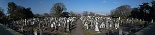
English: Welford Road Cemetery in Leicester. The photograph demonstrates the symmetrical layout of the cemetery: the area on the left is unconsecrated ground for non-conformists, while the area on the right is consecrated ground for Anglicans. There is a noticeable difference between the monuments in each area. |
| Date | |
| Source | Own work |
| Author | NotFromUtrecht |
| Camera location | | View this and other nearby images on: OpenStreetMap |
|---|
Licensing
I, the copyright holder of this work, hereby publish it under the following licenses:
This file is licensed under the Creative Commons Attribution-Share Alike 3.0 Unported license.
- You are free:
- to share – to copy, distribute and transmit the work
- to remix – to adapt the work
- Under the following conditions:
- attribution – You must give appropriate credit, provide a link to the license, and indicate if changes were made. You may do so in any reasonable manner, but not in any way that suggests the licensor endorses you or your use.
- share alike – If you remix, transform, or build upon the material, you must distribute your contributions under the same or compatible license as the original.

|
Permission is granted to copy, distribute and/or modify this document under the terms of the GNU Free Documentation License, Version 1.2 or any later version published by the Free Software Foundation; with no Invariant Sections, no Front-Cover Texts, and no Back-Cover Texts. A copy of the license is included in the section entitled GNU Free Documentation License. |
You may select the license of your choice.
File history
Click on a date/time to view the file as it appeared at that time.
| Date/Time | Thumbnail | Dimensions | User | Comment | |
|---|---|---|---|---|---|
| current | 21:59, 8 March 2010 | 23,759 × 5,413 (32.43 MB) | NotFromUtrecht | higher res | |
| 18:35, 16 February 2010 | 13,376 × 3,563 (11.75 MB) | NotFromUtrecht | Wider view (made from same pictures) | ||
| 14:25, 16 February 2010 | 12,704 × 2,233 (9.52 MB) | NotFromUtrecht | {{Information |Description= {{en|Welford Road Cemetery in en:Leicester. The photograph demonstrates the symmetrical layout of the cemetery: the area on the left is unconsecrated ground for non-conformists, while the are |
File usage
The following pages on the English Wikipedia use this file (pages on other projects are not listed):
Global file usage
The following other wikis use this file:
- Usage on pl.wikipedia.org