
File:Weser basin topo.png

Size of this preview: 358 × 599 pixels. Other resolutions: 143 × 240 pixels | 286 × 480 pixels | 458 × 768 pixels | 611 × 1,024 pixels | 2,544 × 4,260 pixels.
Original file (2,544 × 4,260 pixels, file size: 14.31 MB, MIME type: image/png)
| This is a file from the Wikimedia Commons. Information from its description page there is shown below. Commons is a freely licensed media file repository. You can help. |
Summary
| Description |
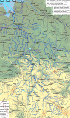
English: Topographic map of Weser River system, with English description |
| Date | |
| Source | Own work |
| Author | Ulamm (talk) |
| Other versions | File:Weser Flusssystem topo.png, German version |
Licensing
I, the copyright holder of this work, hereby publish it under the following licenses:

|
Permission is granted to copy, distribute and/or modify this document under the terms of the GNU Free Documentation License, Version 1.2 or any later version published by the Free Software Foundation; with no Invariant Sections, no Front-Cover Texts, and no Back-Cover Texts. A copy of the license is included in the section entitled GNU Free Documentation License. |
This file is licensed under the Creative Commons Attribution-Share Alike 4.0 International, 3.0 Unported, 2.5 Generic, 2.0 Generic and 1.0 Generic license.
- You are free:
- to share – to copy, distribute and transmit the work
- to remix – to adapt the work
- Under the following conditions:
- attribution – You must give appropriate credit, provide a link to the license, and indicate if changes were made. You may do so in any reasonable manner, but not in any way that suggests the licensor endorses you or your use.
- share alike – If you remix, transform, or build upon the material, you must distribute your contributions under the same or compatible license as the original.
You may select the license of your choice.
File history
Click on a date/time to view the file as it appeared at that time.
| Date/Time | Thumbnail | Dimensions | User | Comment | |
|---|---|---|---|---|---|
| current | 19:22, 24 May 2021 | | 2,544 × 4,260 (14.31 MB) | Ulamm | Schleusenkanal Landesbergen |
| 10:05, 9 February 2018 |  | 2,544 × 4,260 (14.31 MB) | Ulamm | two little corrections | |
| 17:11, 8 February 2018 |  | 2,544 × 4,260 (14.31 MB) | Ulamm | 4 names corrected | |
| 22:54, 25 April 2017 |  | 2,544 × 4,260 (14.31 MB) | Ulamm | flow marks a bit bigger | |
| 15:21, 24 April 2017 |  | 2,544 × 4,260 (14.31 MB) | Ulamm | Klosterbach & Lippstadt | |
| 20:08, 23 April 2017 |  | 2,544 × 4,260 (14.32 MB) | Ulamm | some more names | |
| 02:02, 23 April 2017 |  | 2,544 × 4,260 (14.32 MB) | Ulamm | one more bifurcation | |
| 22:43, 21 April 2017 |  | 2,544 × 4,260 (14.32 MB) | Ulamm | three more rivers, one more place | |
| 19:10, 21 April 2017 |  | 2,544 × 4,260 (14.32 MB) | Ulamm | 3 x Bever | |
| 16:17, 21 April 2017 |  | 2,544 × 4,260 (14.34 MB) | Ulamm | discharge directions of Vehne river and Hamme-Oste-Kanal |
File usage
The following pages on the English Wikipedia use this file (pages on other projects are not listed):
Global file usage
The following other wikis use this file:
- Usage on azb.wikipedia.org
- Usage on bg.wikipedia.org
- Usage on et.wikipedia.org
- Usage on fr.wikipedia.org
- Usage on hr.wikipedia.org
- Usage on it.wikipedia.org
- Usage on nl.wikipedia.org
- Usage on ru.wikipedia.org
- Usage on sv.wikipedia.org
- Usage on sw.wikipedia.org
- Usage on uk.wikipedia.org