
File:Western Germany 1923 de.png

Size of this preview: 370 × 599 pixels. Other resolutions: 148 × 240 pixels | 296 × 480 pixels | 474 × 768 pixels | 632 × 1,024 pixels | 1,406 × 2,276 pixels.
Original file (1,406 × 2,276 pixels, file size: 2.95 MB, MIME type: image/png)
| This is a file from the Wikimedia Commons. Information from its description page there is shown below. Commons is a freely licensed media file repository. You can help. |
Summary
| Description |
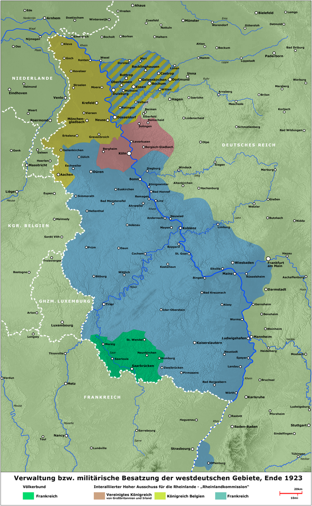
English: Map - Administration and military occupied zones of western Germany by end of 1923
Deutsch: Karte - Verwaltung bzw. Besatzung der westdeutschen Gebiete, Ende 1923
Français : carte des zones occupées dans l'ouest de l'Allemagne à la fin de 1923. |
||
| Date | |||
| Source | several contemporary illustrations - verschiedene zeitgenössische Darstellungen - illustrations de l'époque | ||
| Author | Lothar Velling, Relief: maps-for-free.com | ||
| Permission (Reusing this file) |
|
||
| Other versions | English Version, Arabic Version |
File history
Click on a date/time to view the file as it appeared at that time.
| Date/Time | Thumbnail | Dimensions | User | Comment | |
|---|---|---|---|---|---|
| current | 19:25, 24 September 2020 | | 1,406 × 2,276 (2.95 MB) | JuTa | Please upload it to a different filename |
| 08:16, 18 May 2020 |  | 600 × 1,196 (834 KB) | Jordi | Die Karte ist wie seit langem auf der Diskussionsseite angemerkt grob fehlerhaft. Bisher ist nichts geschehen, um sie zu verbessern. Bis zum Upload einer berichtigten Version durch eine gemeinfreie zeitgenössische Darstellung ersetzt. | |
| 10:12, 2 July 2009 |  | 1,406 × 2,276 (2.95 MB) | SuCapitanidad | Korrektur Ludwigshafen | |
| 17:40, 12 April 2009 |  | 1,405 × 2,273 (2.59 MB) | NordNordWest | Mannheim korrigiert | |
| 16:52, 2 August 2008 |  | 1,405 × 2,273 (3.08 MB) | SuCapitanidad | {{Information |Description= |Source= |Date= |Author= |Permission= |other_versions= }} | |
| 23:33, 10 June 2008 |  | 1,405 × 2,273 (3.06 MB) | SuCapitanidad | {{Information |Description={{en|1=Map - Administration and military occupied zones of western Germany by end of 1923}} {{de|1=Karte - Verwaltung bzw. Besatzung der westdeutschen Gebiete, Ende 1923}} |Source=several contemporary illustrations/verschiedene |
File usage
The following pages on the English Wikipedia use this file (pages on other projects are not listed):
Global file usage
The following other wikis use this file:
- Usage on be.wikipedia.org
- Usage on ca.wikipedia.org
- Usage on cs.wikipedia.org
- Usage on de.wikipedia.org
- Rheinische Republik
- Ruhrbesetzung
- Albrecht Graf von Bernstorff
- Geschichte der Stadt Eschweiler
- Alliierte Rheinlandbesetzung
- Wikipedia:Kartenwerkstatt/Archiv/2009-04
- Autonome Pfalz
- Benutzer:Glglgl/ToDo
- Ruhrfrage
- Gerichte der Alliierten in Deutschland
- Benutzer:GerhardSchuhmacher/Strategische Umgehungsbahn (Schweiz)
- Louis Rivet
- Usage on es.wikipedia.org
- Usage on fr.wikipedia.org
- Usage on hr.wikipedia.org
- Usage on id.wikipedia.org
- Usage on it.wikipedia.org
- Usage on krc.wikipedia.org
- Usage on la.wikipedia.org
- Usage on lt.wikipedia.org
- Usage on lv.wikipedia.org
- Usage on no.wikipedia.org
- Usage on pl.wikipedia.org
- Usage on pt.wikipedia.org
- Usage on ru.wikipedia.org
- Usage on sh.wikipedia.org
- Usage on tr.wikipedia.org
- Usage on uk.wikipedia.org