
File:Western Germany 1923 en.png

Size of this preview: 370 × 599 pixels. Other resolutions: 148 × 240 pixels | 296 × 480 pixels | 474 × 768 pixels | 632 × 1,024 pixels | 1,406 × 2,276 pixels.
Original file (1,406 × 2,276 pixels, file size: 2.95 MB, MIME type: image/png)
| This is a file from the Wikimedia Commons. Information from its description page there is shown below. Commons is a freely licensed media file repository. You can help. |
Summary
| Description |
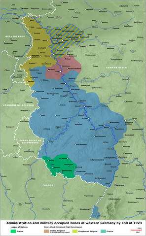
English: Map - Administration and military occupied zones of western Germany by end of 1923
Deutsch: Karte - Verwaltung bzw. Besatzung der westdeutschen Gebiete, Ende 1923 |
| Date | |
| Source | several contemporary illustrations/verschiedene zeitgenössische Darstellungen |
| Author | Lothar Velling, Relief: maps-for-free.com |
| Other versions | German Version, Arabic Version |
Licensing
| I, the copyright holder of this work, release this work into the public domain. This applies worldwide. In some countries this may not be legally possible; if so: I grant anyone the right to use this work for any purpose, without any conditions, unless such conditions are required by law. |
File history
Click on a date/time to view the file as it appeared at that time.
| Date/Time | Thumbnail | Dimensions | User | Comment | |
|---|---|---|---|---|---|
| current | 19:26, 24 September 2020 | | 1,406 × 2,276 (2.95 MB) | JuTa | Please upload it to a different filename |
| 23:28, 16 September 2020 |  | 600 × 1,196 (834 KB) | Jordi | Reverted to version as of 08:50, 18 May 2020 (UTC), reason for substitution was explained here | |
| 10:06, 23 May 2020 |  | 1,406 × 2,276 (2.95 MB) | JuTa | The other one is available at File:Western Germany 1923 de.png | |
| 08:50, 18 May 2020 |  | 600 × 1,196 (834 KB) | Jordi | Same procedure as [https://commons.wikimedia.org/w/index.php?title=File:Western_Germany_1923_de.png&diff=prev&oldid=419997923 here] | |
| 10:17, 2 July 2009 |  | 1,406 × 2,276 (2.95 MB) | SuCapitanidad | Correction Mannheim and Ludwigshafen | |
| 16:49, 2 August 2008 |  | 1,405 × 2,273 (3.08 MB) | SuCapitanidad | {{Information |Description= |Source= |Date= |Author= |Permission= |other_versions= }} | |
| 23:42, 10 June 2008 |  | 1,405 × 2,273 (3.06 MB) | SuCapitanidad | {{Information |Description={{en|1=Map - Administration and military occupied zones of western Germany by end of 1923}} {{de|1=Karte - Verwaltung bzw. Besatzung der westdeutschen Gebiete, Ende 1923}} |Source=several contemporary illustrations/verschiedene |
File usage
The following pages on the English Wikipedia use this file (pages on other projects are not listed):
Global file usage
The following other wikis use this file:
- Usage on ar.wikipedia.org
- Usage on az.wikipedia.org
- Usage on ca.wikipedia.org
- Usage on cs.wikipedia.org
- Usage on es.wikipedia.org
- Usage on fa.wikipedia.org
- Usage on fi.wikipedia.org
- Usage on fr.wikipedia.org
- Usage on he.wikipedia.org
- Usage on it.wikipedia.org
- Usage on ko.wikipedia.org
- Usage on lv.wikipedia.org
- Usage on pl.wikipedia.org
- Usage on pt.wikipedia.org
- Usage on ro.wikipedia.org
- Usage on ru.wikipedia.org
- Usage on th.wikipedia.org
- Usage on uk.wikipedia.org
- Usage on zh.wikipedia.org