
File:Zentralasien politische Karte 2010.svg

Size of this PNG preview of this SVG file: 800 × 591 pixels. Other resolutions: 320 × 237 pixels | 640 × 473 pixels | 1,024 × 757 pixels | 1,280 × 946 pixels | 2,560 × 1,892 pixels | 1,070 × 791 pixels.
Original file (SVG file, nominally 1,070 × 791 pixels, file size: 730 KB)
| This is a file from the Wikimedia Commons. Information from its description page there is shown below. Commons is a freely licensed media file repository. You can help. |
Summary
| Description |
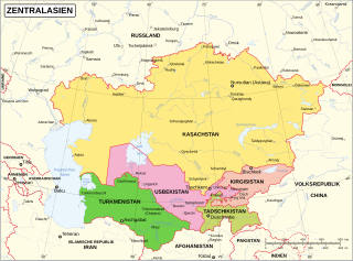
Deutsch: Politische Karte Zentralasiens. |
||
| Date | |||
| Source | Central Asia map | ||
| Author | Abteilung für Kartographie der Vereinten Nationen, modifiziert durch Furfur | ||
| Permission (Reusing this file) |
I, the copyright holder of this work, hereby publish it under the following licenses:
This file is licensed under the Creative Commons Attribution-Share Alike Attribution-Share Alike 4.0 International, 3.0 Unported, 2.5 Generic, 2.0 Generic and 1.0 Generic license.
You may select the license of your choice. |
||
| SVG development | This W3C-invalid map was created with Adobe Illustrator. |

File history
Click on a date/time to view the file as it appeared at that time.
| Date/Time | Thumbnail | Dimensions | User | Comment | |
|---|---|---|---|---|---|
| current | 16:51, 30 June 2019 | | 1,070 × 791 (730 KB) | Furfur | Schriftgröße "Nursultan" größer |
| 13:20, 10 June 2019 |  | 1,070 × 791 (730 KB) | Furfur | Astana -> Nursultan, keine Halbtransparenz | |
| 12:05, 26 May 2019 |  | 1,070 × 791 (730 KB) | Furfur | Kosmetik | |
| 11:36, 26 May 2019 |  | 1,070 × 791 (730 KB) | Minorax | Reverted to version as of 11:23, 26 May 2019 (UTC) failed fix, reverting | |
| 11:36, 26 May 2019 |  | 512 × 378 (723 KB) | Minorax | minor edit // Editing SVG source code using User:Rillke/SVGedit.js; upload handled by User:Rillke/MwJSBot.js | |
| 11:23, 26 May 2019 |  | 1,070 × 791 (730 KB) | Furfur | quailtativ bessere Karte (richtiges SVG) | |
| 20:45, 23 November 2014 |  | 2,048 × 1,532 (249 KB) | Sae1962 | Überlappenden Text verschoben | |
| 20:04, 23 November 2014 |  | 2,048 × 1,532 (249 KB) | Sae1962 | User created page with UploadWizard |
File usage
The following pages on the English Wikipedia use this file (pages on other projects are not listed):
Global file usage
The following other wikis use this file:
- Usage on de.wikipedia.org
- Zentralasien
- Vertrag von Semei
- Wikipedia:WikiProjekt Zentralasien
- Wikipedia Diskussion:WikiProjekt Zentralasien
- Benutzer:Iceland09/Zentralasien/WikiProjekt
- Wikipedia:WikiProjekt Zentralasien/Kirgisistan
- Wikipedia:WikiProjekt Zentralasien/Turkmenistan
- Wikipedia:WikiProjekt Zentralasien/Tadschikistan
- Wikipedia:WikiProjekt Zentralasien/Usbekistan
- Wikipedia:WikiProjekt Zentralasien/Kasachstan
- Wikipedia:WikiProjekt Zentralasien/Qualität
- Wikipedia:WikiProjekt Zentralasien/Mitarbeit
- Wikipedia:WikiProjekt Zentralasien/Literatur
- Wikipedia:WikiProjekt Zentralasien/Werkzeuge
- Unruhen in Kasachstan 2022
- Usage on de.wikivoyage.org
- Usage on hy.wikipedia.org