
File:Zimmermans-island-site-tn1.jpg

Size of this preview: 800 × 493 pixels. Other resolutions: 320 × 197 pixels | 640 × 394 pixels | 1,024 × 631 pixels | 1,280 × 788 pixels | 2,041 × 1,257 pixels.
Original file (2,041 × 1,257 pixels, file size: 438 KB, MIME type: image/jpeg)
| This is a file from the Wikimedia Commons. Information from its description page there is shown below. Commons is a freely licensed media file repository. You can help. |
Summary
| Description |
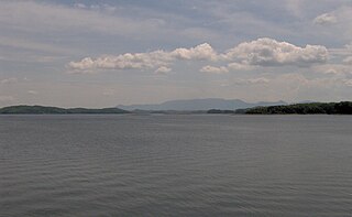
English: The now-submerged site of Zimmerman's Island, looking east from the Douglas Dam boat ramp in Sevier County, Tennessee, in the southeastern United States. The county line crosses the lake, and the island itself was entirely in Jefferson County. Zimmerman's Island is believed to have been the location of the capital of the ancient chiefdom of Chiaha, visited by Spanish explorers Hernando De Soto in 1540 and Juan Pardo in 1567. A fortified village on the island was called "Chiaha" by De Soto and "Olamico" by Juan Pardo. The island was completely submerged by the completion of Douglas Dam in 1943.
English Mountain, the highest of the Foothills of the Great Smoky Mountains, spans the horizon. |
| Date | |
| Source | Own work |
| Author | Brian Stansberry |
Licensing
I, the copyright holder of this work, hereby publish it under the following license:
This file is licensed under the Creative Commons Attribution 3.0 Unported license.
- You are free:
- to share – to copy, distribute and transmit the work
- to remix – to adapt the work
- Under the following conditions:
- attribution – You must give appropriate credit, provide a link to the license, and indicate if changes were made. You may do so in any reasonable manner, but not in any way that suggests the licensor endorses you or your use.
File history
Click on a date/time to view the file as it appeared at that time.
| Date/Time | Thumbnail | Dimensions | User | Comment | |
|---|---|---|---|---|---|
| current | 00:34, 7 July 2008 | | 2,041 × 1,257 (438 KB) | BrineStans | {{Information |Description={{en|1=The now-submerged site of Zimmerman's Island, looking east from the Douglas Dam boat ramp in Sevier County, Tennessee, in the southeastern United States. The county line crosses the lake, and the island itself was entire |
File usage
The following pages on the English Wikipedia use this file (pages on other projects are not listed):
Global file usage
The following other wikis use this file:
- Usage on ca.wikipedia.org