
File talk:Duchy of Vasconia.gif
(copy-pasted from Talk:History_of_the_Basque_people)
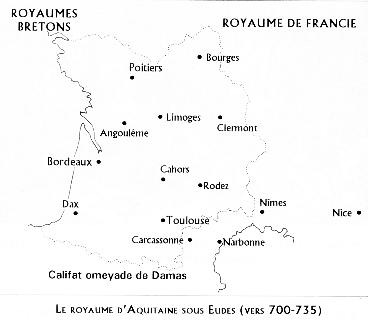
I don't see any written source, outside the Auñamendi map (not corroborated by the text nearby, indeed) that would give any hint that Odo's duchy did extend south of the Pyrénées. A general book about French history I fetch tells me he was "master of most cities between the Loire and Pyrénées", but I see nothing giving any suggestion he controlled any bit of territory in present Euskadi or Navarra. I see hints of a Basque army he led, trying to conquer northern France (and defeated near Soissons, not precisely in Basque country !), but as far as I know, "Duchy of Vasconia" has nothing to do with any territory nowadays Spanish (except perhaps at Charlemagne's apogee, and only marginally in badly known conditions).
Hence I think this map is not scientific enough to be used in articles. French Tourist (talk) 07:46, 27 November 2007 (UTC)
- Oups I discover there had been a thread about this map at Talk:Duchy_of_Vasconia. It might be better to keep all comments about its usefulness there , I suggest not to keep talking here. French Tourist (talk) 07:48, 27 November 2007 (UTC)
- The proper place to discuss the map is here. I have said it several times.
- The facts are that, once the Duchy became de facto independent, soon after its creation, it included all Basque lands. You (and others) assume too much power to Merovingian Franks (who were almost all the time fighting among themselves and had no forces to keep efefctive control of their periphery) and Visigoths (two thirds of the same). Even Carolingians were most of the time in civil war as well.
- You also seem to assume that there was some "magic" defining the border between modern Spain and France. In fact, that border was abslutely non-existent and both Goths and Franks had claims on each other's territory and often fought for it. Basques were in the middle and normally fought for their own interest, it seems, eventually being unified under the "independent" Duchy of Vasconia.
- The case is that the term Vasconia/Wasconia is in all sources coincident for a geogrpahy between the upper Ebro and the Garonne. Gothic documents do not mention the Duchy as such but just talk of "Vascones" and "Vasconia" but the sources are very sparce and unclear and nothing points to any artificial border at the Bidasoa and the Pyrenees, border that for most purposes has aout two centuries of history, not more. In any case, the Goths hardly ever conquered anything north of Olite and, in any case, when the Muslims finally conquer Vasconia, they do through Pamplona, after being defeated at Tolouse.
- The mention of Soissons, seems completely irrelevant. If Eudes was fighting the Franks, it's only logic that he fought in Francia (originally the area directly controlled by the Franks: Northern modern France, Rhineland, Belgium, Franconia). He did not only command Basques but also Aquitanians, as you should know well, the romanized people with a Gothic (?) aristocracy between the Garonne and the Loire. --Sugaar (talk) 10:35, 29 November 2007 (UTC)
- "The facts are that, once the Duchy became de facto independent, soon after its creation, it included all Basque lands."
- Let's try to check it. I have opened most if not all the sources which have been alluded to in Talk:Duchy_of_Vasconia. Which ones do support your assertion ?
- 1) The map itself [1] does not contain the word "Duchy". The legend of the map on the page the relevant page of Auñamendi encyclopedia does not contain the word "Duchy" either, but the expression "el estado vascón-aquitano" which indeeds probably refers to the Duchy.
- 2) Some sentences in the Auñamendi entry about Duchy of Vasconia ("1° Vasconia es un entidad que se extiende desde el mediodia de la actual Alava hasta el norte de la actual Zuberoa ya que en 58l la atacan en esos dos puntos para penetrar en su interior. Ambos reyes dicen entrar militarmente en Vasconia. 2° Entre los pueblos del norte, Geta, Dano, Estio, Saxo y Britano, se cita al wasco, lo que deja ver, que, contra lo que algunos historiadores creen, existían de siempre vascos en la antigua tierra aquitana. 3 º La acción Militar simultánea desde las orillas del Adur y las del Ebro, dejan ver que Vasconia constituía un peligro para ambos dominadores, el franco y el godo.(...)"). These sentences refer to Vasconia, not "Ducado de Vasconia". As I read them, they refer to "Vasconia", the area populated by Vascones -the topic of the Vascones article, not to the Duchy. Using them as sources would seem as dubious as using the sentence "Ireland extends from Kerry to Belfast" to prove that Belfast is part of the Republic of Ireland. Cultural/ethnic borders have no reason to be the same as political/military borders.
- 3) I must concede that in one of the websites you hinted to, that is this one, I could read a much more precise sentence, that is : "En la época de las invasiones bárbaras, posterior a Roma, se formó el ducado de Vasconia, que se extendía desde los tradicionales confines vascos en el valle del Ebro hasta el río Loire, confinando al sur con los visigodos, y al norte y este con los francos.". This source, though, is not a book but excerpts from a book, I have no idea of the qualifications of its author (Ildefonso Gurrutxaga if I understood it well), and no hint of the reasonings/primary sources he used to get to this conclusion. I cannot consider this source as usable in its present state.
- On the other hand, at least two books from my bookshelves (Stéphane Lebecq - Les origines franques ISBN 2020115522 (a book about French history) and Histoire médiévale de la Péninsule ibérique (Adeline Rucquoi) ISBN 2020129353), though containing several referrences to Vascones, make absolutely no hint of Frankish control in Navarra at Odon's period. More strikingly the map this map from a rough (amateur) history of Aquitaine which seems to be extracted from Michel Rouche's dissertation about medieval Aquitaine does not look at all like the image we are discussing, with no extensions of Aquitaine south of the present border (except probably marginally, to the extent where Bayonne diocese contained places now Spanish, like Pasaia or Bastan).
- With all these elements in hand, I can't agree with you : I don't see the control of southern Basque country by the Duchy as a fact but at least as some very dubious assertion.
![[1]](http://www.euskomedia.org/ImgsAuna/09042001.jpg)
- "You also seem to assume that there was some "magic" defining the border between modern Spain and France."
- I don't think I do, as you see I know perfectly well that Pasaia and Bastan have been part of Labourd long ago, or of course that Lower Navarre has been in French control for less than 500 years now, and that the border in this area is quite a recent creation, with all its funny tricks in Quinto Real, Valcarlos/Ondarolle or Irati forest. I don't think I suffer from "magic thinking" when considering these historico-geographical questions. Anyway, my possible biases are irrelevant since we are discussing a map I have not authored.
- "The case is that the term Vasconia/Wasconia is in all sources coincident for a geogrpahy between the upper Ebro and the Garonne".
- Absolutely OK with that, but I don't see the point : Vasconia is larger than Duchy of Vasconia, the same way as Ireland is larger than Republic of Ireland.
- "The mention of Soissons, seems completely irrelevant".
- OK with this one, let's forget it, we have enough to do with the Basque coutry :-).
- I shall make a copy of our dialogue on Talk:Duchy of Vasconia ; I think it is at least relevant on both pages. Feel free to answer on whatever you like. French Tourist (talk) 16:14, 29 November 2007 (UTC)