
Puerto Rico Highway 145
(Redirected from Highway 145 (Puerto Rico))
This article may require cleanup to meet Wikipedia's quality standards. The specific problem is: Image placement. (April 2024) |
Highway 145 | ||||
|---|---|---|---|---|
| Ruta 145 | ||||
| Route information | ||||
| Maintained by Puerto Rico DTPW | ||||
| Length | 7.5 km[1] (4.7 mi) | |||
| Major junctions | ||||
| West end | ||||
| ||||
| East end | ||||
| Location | ||||
| Country | United States | |||
| Territory | Puerto Rico | |||
| Municipalities | Ciales, Morovis | |||
| Highway system | ||||
| ||||

Puerto Rico Highway 145 (PR-145) is a rural road that travels from Ciales, Puerto Rico to Morovis.[2] This road extends from its junction with PR-146 and PR-149 in downtown Ciales and ends at PR-155 between Morovis Norte, Torrecillas and Fránquez barrios.[3]
- Puerto Rico Highway 145
-
 Heading west in Ciales barrio-pueblo
 -
 Heading west in Torrecillas, Morovis


Major intersections[edit]
-
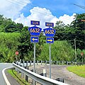 PR-145 west at its junction with PR-6632 in Jaguas, Ciales
 -
 PR-6622 west at its junction with PR-145 and PR-567 south between Morovis Norte and Torrecillas barrios
 -
 PR-634 south at its junction with PR-145 west and PR-155 in Torrecillas, Morovis


| Municipality | Location | km[1] | mi | Destinations | Notes |
|---|---|---|---|---|---|
| Ciales | Jaguas | 0.0 | 0.0 | Western terminus of PR-145 | |
| 0.7– 0.8 | 0.43– 0.50 | ||||
| Morovis | Torrecillas–Morovis Norte line | 6.6– 6.7 | 4.1– 4.2 | ||
| Morovis Norte–Torrecillas– Fránquez tripoint | 7.5 | 4.7 | Eastern terminus of PR-145 | ||
| 1.000 mi = 1.609 km; 1.000 km = 0.621 mi | |||||
See also[edit]
References[edit]
- ^ a b Google (2 March 2020). "PR-145" (Map). Google Maps. Google. Retrieved 2 March 2020.
- ^ National Geographic Maps (2011). Puerto Rico (Map). 1:125,000. Adventure Map (Book 3107). Evergreen, Colorado: National Geographic Maps. ISBN 978-1566955188. OCLC 756511572.
- ^ "Tránsito Promedio Diario (AADT)". Puerto Rico Department of Transportation and Public Works (in Spanish). p. 79. Archived from the original on 1 April 2019. Retrieved 30 May 2019.
External links[edit]
 Media related to Puerto Rico Highway 145 at Wikimedia Commons
This Puerto Rico road-related article is a stub. You can help Wikipedia by expanding it. |