
Puerto Rico Highway 148
Highway 148 | ||||
|---|---|---|---|---|
| Ruta 148 | ||||
| Route information | ||||
| Maintained by Puerto Rico DTPW | ||||
| Length | 0.8 km[1] (0.50 mi; 2,600 ft) | |||
| Major junctions | ||||
| South end | ||||
| North end | ||||
| Location | ||||
| Country | United States | |||
| Territory | Puerto Rico | |||
| Municipalities | Naranjito | |||
| Highway system | ||||
| ||||

Puerto Rico Highway 148 (PR-148) is a short north–south road that connects from PR-5 to PR-167 in Naranjito, Puerto Rico.[2]
Route description[edit]
The bypass goes through Comerío and Guadiana barrio from PR-5 because PR-167 (between Bayamón and Naranjito) has many curves. Originally PR-148 also ran to west (from its junction with PR-5 and PR-826) to the former PR-147 near the downtown of Naranjito to improve the access from the east because PR-164 (like PR-167) has many curves in Barrio Nuevo area.[3] Actually the former PR-147 and the east–west section of this route is now part of PR-5.
-
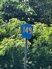 Puerto Rico Highway 148 north in Barrio Nuevo
.jpg)
Major intersections[edit]
The entire route is located in Naranjito.
-
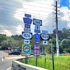 PR-167 south at PR-148 and PR-164 intersection in Barrio Nuevo
 -
 PR-148 north at PR-5 and PR-826 intersection in Guadiana barrio
.jpg)

| Location | km[1] | mi | Destinations | Notes | |
|---|---|---|---|---|---|
| Nuevo | 0.0 | 0.0 | Southern terminus of PR-148 | ||
| Guadiana | 0.5 | 0.31 | Former PR-826 | ||
| 0.8 | 0.50 | Northern terminus of PR-148 | |||
| 1.000 mi = 1.609 km; 1.000 km = 0.621 mi | |||||
See also[edit]
References[edit]
- ^ a b Google (2 March 2020). "PR-148" (Map). Google Maps. Google. Retrieved 2 March 2020.
- ^ National Geographic Maps (2011). Puerto Rico (Map). 1:125,000. Adventure Map (Book 3107). Evergreen, Colorado: National Geographic Maps. ISBN 978-1566955188. OCLC 756511572.
- ^ "Tránsito Promedio Diario (AADT)". Transit Data (Datos de Tránsito) (in Spanish). Puerto Rico Department of Transportation and Public Works. p. 79. Archived from the original on 1 April 2019. Retrieved 19 July 2011.
External links[edit]
 Media related to Puerto Rico Highway 148 at Wikimedia Commons
This Naranjito, Puerto Rico location article is a stub. You can help Wikipedia by expanding it. |
This Puerto Rico road-related article is a stub. You can help Wikipedia by expanding it. |