
Puerto Rico Highway 164
Highway 164 | ||||
|---|---|---|---|---|
| Ruta 164 | ||||
| Route information | ||||
| Maintained by Puerto Rico DTPW | ||||
| Length | 16.4 km[1][2] (10.2 mi) | |||
| Existed | 1953[3][4]–present | |||
| Major junctions | ||||
| West end | ||||
| East end | ||||
| Location | ||||
| Country | United States | |||
| Territory | Puerto Rico | |||
| Municipalities | Corozal, Naranjito | |||
| Highway system | ||||
| ||||


Puerto Rico Highway 164 (PR-164) is the main road from Naranjito to Corozal in Puerto Rico.[5] It begins at the intersection of PR-167 and PR-148 in eastern Naranjito, passing through downtown. Then it goes to Corozal from its junction with PR-5 and PR-152 until reaching PR-159 near downtown Corozal.[6] This road is 16.4 km (10.2 mi) in length.
Route description[edit]
This highway consists of one lane in each direction for most of its length between Naranjito and Corozal. In Naranjito, PR-164 travels from its intersection with PR-148 and PR-167 in Barrio Nuevo to the Corozal municipal limit, crossing through downtown Naranjito, Achiote and Lomas barrios on its way across this municipality.[7] In Corozal, PR-164 travels from the Naranjito municipal limit to its western terminus at PR-159 junction, passing through Palmarejo and Barrio Pueblo.[8] Among the most important intersections are PR-5, that goes to Bayamón; PR-152, that heads to Barranquitas; PR-159, the main highway between Morovis and Toa Alta; PR-165, which leads to Toa Alta, and PR-167, the main road between Comerío and Bayamón.
- Puerto Rico Highway 164 by municipality
-
 Heading west in Barrio Nuevo, Naranjito
 -
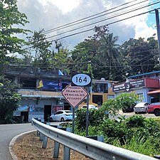
 Southbound sign between Achiote and Naranjito barrio-pueblo
 -
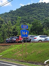
 Eastbound sign in Palmarejo, Corozal
.jpg)
.jpg)

Rivers crossed[edit]
Puerto Rico Highway 164 crosses the following rivers:
- Quebrada Anones in Naranjito[9]
- Río Cañas in Naranjito[10]
- Río Guadiana in Naranjito[11]
- Río Mavilla in Corozal[12]
History[edit]
The entire length of PR-164 is part of the eastern section of the old Road No. 20, a highway that led from Naranjito to Ciales through Corozal and Morovis until the 1953 Puerto Rico highway renumbering, a process implemented by the Puerto Rico Department of Transportation and Public Works (Spanish: Departamento de Transportación y Obras Públicas) that increased the insular highway network to connect existing routes with different locations around Puerto Rico. Route 20 was divided into two segments: the first one, from Naranjito to Corozal, and the second one, from Corozal to Ciales.[13] The first section corresponds to the current PR-164 from PR-167 (old Road No. 9) to PR-159 (former Road No. 10),[3] while the second one went to Morovis through PR-159,[4] beginning at its junction with PR-568 (old Road No. 10) in western Corozal to continue to Ciales through PR-155, PR-633 and PR-6633 until its end at PR-6685 (former Road No. 11).[14]
Major intersections[edit]
-
 PR-167 south at PR-148 and PR-164 intersection in Barrio Nuevo, Naranjito
 -
 PR-159 east approaching PR-164 intersection in Barrio Pueblo, Corozal
 -
 PR-164 east near the northern terminus of PR-803 in Palmarejo, Corozal
 -
 PR-164 east at PR-803 intersection in Palmarejo, Corozal
.jpg)

.jpg)
.jpg)
| Municipality | Location | km[1][2] | mi | Destinations | Notes |
|---|---|---|---|---|---|
| Corozal | Pueblo–Palmarejo line | 16.4 | 10.2 | Western terminus of PR-164 | |
| Palmarejo | 13.7 | 8.5 | |||
| Naranjito | Lomas | 11.0 | 6.8 | ||
| 10.9– 10.8 | 6.8– 6.7 | ||||
| 9.8 | 6.1 | ||||
| Achiote | 7.7 | 4.8 | |||
| Achiote–Naranjito barrio-pueblo line | 6.4– 6.3[a] | 4.0– 3.9 | |||
| Southern terminus of PR-5 concurrency | |||||
| Northern terminus of PR-5 concurrency | |||||
| Naranjito barrio-pueblo | 6.1 | 3.8 | |||
| 5.9 | 3.7 | ||||
| Nuevo | 4.9 | 3.0 | Former highway | ||
| 2.9 | 1.8 | ||||
| 0.7 | 0.43 | Former PR-826 | |||
| 0.0 | 0.0 | Eastern terminus of PR-164 | |||
1.000 mi = 1.609 km; 1.000 km = 0.621 mi
| |||||
- ^ PR-164 kilometer markers are interrupted on Desvío Mariano Cotto.
See also[edit]
References[edit]
- ^ a b Google (2 March 2020). "PR-164 east" (Map). Google Maps. Google. Retrieved 2 March 2020.
- ^ a b Google (2 March 2020). "PR-164 west" (Map). Google Maps. Google. Retrieved 2 March 2020.
- ^ a b "Naranjito, Memoria Núm. 53" (PDF). Puerto Rico Planning Board (in Spanish). 1955. Retrieved 6 August 2023.
- ^ a b "Corozal, Memoria Núm. 61" (PDF). Puerto Rico Planning Board (in Spanish). 1955. Retrieved 22 February 2020.
- ^ National Geographic Maps (2011). Puerto Rico (Map). 1:125,000. Adventure Map (Book 3107). Evergreen, Colorado: National Geographic Maps. ISBN 978-1566955188. OCLC 756511572.
- ^ Puerto Rico Department of Transportation and Public Works. "Datos de Transito 2000-2009" (in Spanish). Archived from the original on 1 April 2019. Retrieved 29 April 2019.
- ^ "PR-164, Naranjito, Puerto Rico". pr.geoview.info. Retrieved 5 August 2023.
- ^ "PR-164, Corozal, Puerto Rico". pr.geoview.info. Retrieved 5 August 2023.
- ^ Press, Detroit Free. "PR 164 over ANONES CREEK Naranjito Municipio, Puerto Rico Bridge Inspection Report". Detroit Free Press. Retrieved 9 August 2023.
- ^ Press, Detroit Free. "PR 164 over CA%AS RIVER Naranjito Municipio, Puerto Rico Bridge Inspection Report". Detroit Free Press. Retrieved 9 August 2023.
- ^ Press, Detroit Free. "PR 164 over GUADIANA RIVER Naranjito Municipio, Puerto Rico Bridge Inspection Report". Detroit Free Press. Retrieved 9 August 2023.
- ^ Press, Detroit Free. "PR 164 over MAVILLA RIVER Corozal Municipio, Puerto Rico Bridge Inspection Report". Detroit Free Press. Retrieved 9 August 2023.
- ^ "Revista de Obras Públicas de Puerto Rico, Febrero 1929". Colección Puertorriqueña UPR RP (in Spanish). 1929. pp. 22–23. Retrieved 6 August 2023.
- ^ "Morovis, Memoria Núm. 65" (PDF). Puerto Rico Planning Board (in Spanish). 1955. Retrieved 6 August 2023.
External links[edit]
 Media related to Puerto Rico Highway 164 at Wikimedia Commons