
Puerto Rico Highway 820
Highway 820 | ||||
|---|---|---|---|---|
| Ruta 820 | ||||
| Carretera Marzán | ||||
| Route information | ||||
| Maintained by Puerto Rico DTPW | ||||
| Length | 2.1 km[1] (1.3 mi) | |||
| Existed | 1953[2]–present | |||
| Major junctions | ||||
| West end | ||||
| East end | ||||
| Location | ||||
| Country | United States | |||
| Territory | Puerto Rico | |||
| Municipalities | Vega Alta, Toa Alta | |||
| Highway system | ||||
| ||||

Puerto Rico Highway 820 (PR-820) is an east–west road between the municipalities of Toa Alta and Vega Alta in Puerto Rico.[3] With a length of 2.1 kilometers (1.3 mi),[1] it extends from PR-823 in Río Lajas barrio to its intersection with PR-677 and PR-678 in Maricao barrio.[4]
Route description[edit]
Puerto Rico Highway 820 is a rural road with a single lane per direction along its entire length.[4] In Toa Alta, PR-820 leaves from PR-823, passing through Marzán neighborhood until the Vega Alta municipal limit. In Vega Alta, PR-820 has a short length from the Toa Alta municipal limit until its western terminus at PR-677 and PR-678 intersection. The entire length in Toa Alta is located in Río Lajas barrio,[5] while in Vega Alta it is located entirely in Maricao barrio.[6]
- Puerto Rico Highway 820
-
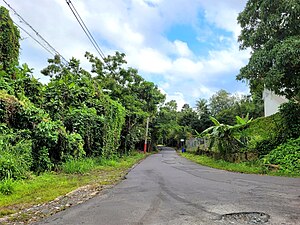 Western terminus at PR-677 and PR-678 intersection in Maricao, Vega Alta, looking east
 -
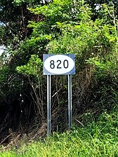 Eastbound sign in Maricao, Vega Alta
.jpg)
.jpg)
Major intersections[edit]
-
 PR-823 east at PR-820 intersection in Río Lajas, Toa Alta
 -
 PR-677 east near PR-678 and PR-820 intersection in Maricao, Vega Alta
 -
 PR-678 south at PR-677 and PR-820 intersection in Maricao, Vega Alta


| Municipality | Location | km[1] | mi | Destinations | Notes |
|---|---|---|---|---|---|
| Vega Alta | Maricao | 2.1 | 1.3 | Western terminus of PR-820 | |
| Toa Alta | Río Lajas | 0.0 | 0.0 | Eastern terminus of PR-820 | |
| 1.000 mi = 1.609 km; 1.000 km = 0.621 mi | |||||
See also[edit]
References[edit]
- ^ a b c Google (17 August 2020). "PR-820" (Map). Google Maps. Google. Retrieved 17 August 2020.
- ^ "Vega Alta, Memoria Núm. 59" (PDF). Puerto Rico Planning Board (in Spanish). 1955. Retrieved 11 May 2021.
- ^ National Geographic Maps (2011). Puerto Rico (Map). 1:125,000. Adventure Map (Book 3107). Evergreen, Colorado: National Geographic Maps. ISBN 978-1566955188. OCLC 756511572.
- ^ a b "PR-820, Toa Alta, Puerto Rico". pr.geoview.info. Retrieved 31 July 2023.
- ^ "Río Lajas Barrio second-order administrative division, Toa Alta, Puerto Rico". pr.geoview.info. Retrieved 31 July 2023.
- ^ "Maricao Barrio second-order administrative division, Vega Alta, Puerto Rico". pr.geoview.info. Retrieved 31 July 2023.
External links[edit]
 Media related to Puerto Rico Highway 820 at Wikimedia Commons
This Puerto Rico road-related article is a stub. You can help Wikipedia by expanding it. |