
Puerto Rico Highway 891
Highway 891 | ||||
|---|---|---|---|---|
| Ruta 891 | ||||
| Route information | ||||
| Maintained by Puerto Rico DTPW | ||||
| Length | 1.8 km[1] (1.1 mi) | |||
| Major junctions | ||||
| West end | ||||
| East end | ||||
| Location | ||||
| Country | United States | |||
| Territory | Puerto Rico | |||
| Municipalities | Corozal | |||
| Highway system | ||||
| ||||

Puerto Rico Highway 891 (PR-891) is the road that goes to downtown Corozal, the administrative center of Corozal, Puerto Rico.[2] With a length of 1.8 km (1.1 mi), this road can be seen as the Alt 159, since it was the original alignment of PR-159 through the municipal center.[3]
Route description[edit]
This highway consists of one lane in each direction for most of its length. PR-891 begins at its junction with PR-159 in western Barrio Pueblo. Then, it crossess the Río Corozal,[4] a tributary of the Río Cibuco, and enters the city center, where it meets with PR-821 and PR-807 around the town square.[5] After those intersections, PR-891 heads to the east, leaving the downtown area until its end at PR-159 in eastern Barrio Pueblo.[6]
-
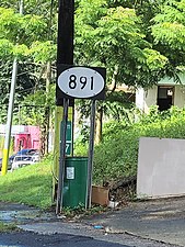 Sign for PR-891 in Barrio Pueblo, Corozal, looking west
 -
 PR-159 west approaching PR-891 intersection in Barrio Pueblo, Corozal
 -
 PR-159 east at PR-891 intersection in Barrio Pueblo, Corozal

.jpg)
.jpg)
Component streets[edit]
Puerto Rico Highway 891 makes its way within the urban area through the following streets:
- Calle Bou, from PR-159 to Calle Sixto Febus (Cervantes)[7]
- Calle Sixto Febus (Cervantes), from Calle Bou to Calle Gándara[a][8]
- Calle Gándara, from Calle Sixto Febus (Cervantes) to Calle Urbano Ramírez (Toa Alta)
- Calle Urbano Ramírez (Toa Alta), from Calle Gándara to PR-159[9]
History[edit]
Like a part of PR-159, the entire length of PR-891 is part of the old Road No. 10, a highway that led from Dorado to Coamo through Toa Alta, Corozal and Orocovis until the 1953 Puerto Rico highway renumbering, a process implemented by the Puerto Rico Department of Transportation and Public Works (Spanish: Departamento de Transportación y Obras Públicas) that increased the insular highway network to connect existing routes with different locations around Puerto Rico. Route 10 extended from PR-165 (old Road No. 2) near Toa Alta to PR-14 (former Road No. 1) in downtown Coamo.[10] Its original way currently corresponds to PR-165, from PR-8865 in Dorado to PR-159 in Toa Alta;[11] PR-159, from PR-165 in Toa Alta to PR-568 in Corozal, except in downtown area, where PR-891 replaces PR-159;[3] PR-568, from PR-159 in Corozal to PR-5155 in Orocovis;[12] PR-5155, from PR-568 north of downtown to PR-155 south of downtown, and PR-155, from PR-5155 in Orocovis to PR-14 in Coamo.[13]
Major intersections[edit]
The entire route is located in Corozal.
| Location | km[1] | mi | Destinations | Notes | |
|---|---|---|---|---|---|
| Corozal barrio-pueblo–Pueblo line | 0.0 | 0.0 | Western terminus of PR-891 | ||
| Corozal barrio-pueblo | 0.8 | 0.50 | One-way street; northbound access via Calle Colón | ||
| Pueblo | 1.8 | 1.1 | Eastern terminus of PR-891 | ||
| 1.000 mi = 1.609 km; 1.000 km = 0.621 mi | |||||
See also[edit]
Notes[edit]
- ^ Since Calle Sixto Febus (Cervantes) moves from east to west as a one-way street, traffic from west to east must move through Calle San Manuel and Calle Gándara south of the town square.
References[edit]
- ^ a b Google (29 February 2020). "PR-891" (Map). Google Maps. Google. Retrieved 29 February 2020.
- ^ "Tránsito Promedio Diario (AADT)". Transit Data (Datos de Transito) (in Spanish). DTOP PR. p. 134. Archived from the original on 1 April 2019.
- ^ a b "Corozal, Memoria Núm. 61" (PDF). Puerto Rico Planning Board (in Spanish). 1955. Retrieved 8 August 2023.
- ^ Press, Detroit Free. "PR 891 over COROZAL RIVER Corozal Municipio, Puerto Rico Bridge Inspection Report". Detroit Free Press. Retrieved 9 August 2023.
- ^ National Geographic Maps (2011). Puerto Rico (Map). 1:125,000. Adventure Map (Book 3107). Evergreen, Colorado: National Geographic Maps. ISBN 978-1566955188. OCLC 756511572.
- ^ "PR-891, Corozal, Puerto Rico". pr.geoview.info. Retrieved 2 March 2016.
- ^ "Calle Bou, Corozal, Puerto Rico". pr.geoview.info. Retrieved 8 August 2023.
- ^ "Calle Cervantes, Corozal, Puerto Rico". pr.geoview.info. Retrieved 8 August 2023.
- ^ "Calle Toa Alta, Corozal, Puerto Rico". pr.geoview.info. Retrieved 8 August 2023.
- ^ "Revista de Obras Públicas de Puerto Rico, Febrero 1929". Colección Puertorriqueña UPR RP (in Spanish). 1929. pp. 22–23. Retrieved 8 August 2023.
- ^ "Toa Alta, Memoria Núm. 57" (PDF). Puerto Rico Planning Board (in Spanish). 1955. Retrieved 8 August 2023.
- ^ "Orocovis, Memoria Núm. 47" (PDF). Puerto Rico Planning Board (in Spanish). 1955. Retrieved 8 August 2023.
- ^ "Coamo, Memoria Núm. 33" (PDF). Puerto Rico Planning Board (in Spanish). 1953. Retrieved 8 August 2023.
External links[edit]
 Media related to Puerto Rico Highway 891 at Wikimedia Commons