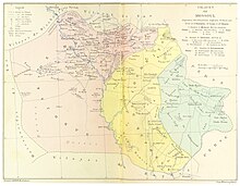
Kirkuk Sanjak
This article has multiple issues. Please help improve it or discuss these issues on the talk page. (Learn how and when to remove these template messages)
|
| Ottoman Turkish: كركوك سنجاغى | |||||||||
|---|---|---|---|---|---|---|---|---|---|
| Sanjak of the Ottoman Empire | |||||||||
| 1534–1918 | |||||||||
 The Kirkuk Sanjak in 1892 | |||||||||
| Capital | Kirkuk | ||||||||
| Population | |||||||||
• 1912 | 89,573 | ||||||||
| History | |||||||||
• Established | 1534 | ||||||||
| 1918 | |||||||||
| |||||||||
| Today part of | Iraq | ||||||||
The Kirkuk Sanjak (Turkish: Kerkük Sancağı, كركوك سنجاغى) was a second-level administrative division that included parts of the governorates of Saladin, Sulaymaniah, and Diyala, as well as all of Erbil and Kirkuk. Its capital was Kirkuk. It was made up of 6 districts, 17 subdistricts and 1,712 Villages. The largest town in the Sanjak was Kirkuk, with a population of approximately 50,000 people with 30,000 of them being Turks. The most important villages were Altun kupri,Rwanaduz and Daquq.[1]
History[edit]
In 1534, the Ottoman Empire incorporated the region of Kirkuk, along with much of present-day Iraq, into its domains. Kirkuk's importance grew in the 18th century when it became the capital of the Ottoman Sanjak of Şehrizor, which included the territories of Kirkuk, Erbil, and Sulaymaniyah. Following the reforms of Midhat Pasha, who served as governor of Baghdad between 1869 and 1872, the Sanjak of Kirkuk was renamed Şehrizor, corresponding to the present-day areas of Kirkuk and Erbil. The city flourished with Ottoman culture.[2]
Name change[edit]
Kirkuk sanjak, It was referred to as "Şehr-i Zor" in official correspondence until mid-1892. However, the similarity of the name with "Zor Mutasarrıflığı" caused confusion. The name "Kirkuk" began to be used in 1893 by the will of the Sultan. Arabs call Kirkuk "Karkuk". The name Kirkuk was first used by Şerefeddin. It is mentioned in Yazdi's history of Timur. Kirkuk Turks, 900 years ago 24 Oghuz tribes who settled in the region (Mosul, Kirkuk and their surroundings) and made their homeland[3]
Geography[edit]
The geography known as kirkuk today has been settled by Turks since 674. It has become a unique region. This place has history, geography, climate, natural conditions and ethnic structure.
Kirkuk sanjak is located in the east of the "Cezire" region between the Tigris River meets Hamrin Mountains, which separate the region with the Tigris River in the West, and the Little Mountains in the Northeast. It is surrounded by the Zapsu valley and the Diyale valley in the southeast.[3]
Demographics[edit]
Although there are not many exact numbers but estimates put that Kirkuk Sanjak used to be 90-80% Turkish as well as decent Kurdish, Arab,Assyrian and Hebrew populations.
In 1912 it was estimated that the sanjak had 89,573 with the vast majority of them being Muslims.[1]
Subdivisions[edit]
It's divided into 6 districts, 17 subdistricts and 1,712 Villages. The most populated district in 1912 was Kirkuk with a population of 36,585 and the least populated was Salahiye with a population of 5,482.[1]
References[edit]
- ^ a b c "Mosul vilayet in the Ottoman empire" (PDF). Orsam.com.
- ^ Güçlü, Yücel (2007-01-01). "Who Owns Kirkuk? The Turkoman Case". Middle East Quarterly.
- ^ a b "Kirkuk sanjak". Kirkuk Issue.
