
Kogarah, New South Wales
| Kogarah Sydney, New South Wales | |||||||||||||||
|---|---|---|---|---|---|---|---|---|---|---|---|---|---|---|---|
 Kogarah Community Centre | |||||||||||||||
 Map | |||||||||||||||
| Population | 16,416 (2021 census)[1] | ||||||||||||||
| • Density | 6,310/km2 (16,350/sq mi) | ||||||||||||||
| Established | 1885 | ||||||||||||||
| Postcode(s) | 2217 | ||||||||||||||
| Elevation | 29 m (95 ft) | ||||||||||||||
| Area | 2.6 km2 (1.0 sq mi) | ||||||||||||||
| Location | 14 km (9 mi) south-west of Sydney CBD | ||||||||||||||
| LGA(s) | |||||||||||||||
| State electorate(s) | Kogarah | ||||||||||||||
| Federal division(s) | |||||||||||||||
| |||||||||||||||
Kogarah (/kɒɡərə/) is a suburb of Southern Sydney, in the state of New South Wales, Australia. Kogarah is located 14 kilometres (9 miles) south-west of the Sydney central business district and is considered to be the centre of the St George area.
Location[edit]
Kogarah took its name from Kogarah Bay, a small bay on the northern shore of the Georges River. The suburb originally stretched to the bay but has since been divided up to form the separate suburbs of Kogarah Bay and Beverley Park.
Kogarah has a mixture of residential, commercial and light industrial areas. It is also known for its large number of schools (including primary school, high school and tertiary education) and health care services (including two hospitals and many medical centres). The NRL side, St George Illawarra Dragons have their Sydney office based at nearby Jubilee Oval, often referred to as Kogarah Oval. Kogarah features all types of residential developments from low density detached houses, to medium density flats and high density high-rise apartments.
History[edit]

Kogarah is derived from an Aboriginal word meaning rushes or place of reeds.[2] It had also been written as 'Coggera', 'Cogerah' and 'Kuggerah' but the current spelling was settled when the railway line came through the area in the 1880s.
Early land grants in the area were made to John Townson (1760–1835) who received 910 hectares (2,250 acres) from 1808 to 1810, centred on Hurstville and James Chandler, whose neighbouring estate was centred on Bexley. The district provided fruit, vegetables and oysters for Sydney. In 1869, St Paul's Church of England opened on Rocky Point Road (now Princes Highway). It was built on 0.81 hectares (2 acres) of land given to the church by William Wolfen the Swedish Consul to Sydney, who owned 320 hectares (800 acres) in Kogarah. The suburb grew around the church and the Gardeners Arms Hotel. Kogarah became a municipality in 1885.[3]
The former neighbourhood of Moorefield is now part of Kogarah. It was originally a 24-hectare (60-acre) land grant from Governor Lachlan Macquarie in 1812 to Patrick Moore, who built a fine house there. The Moorefield racecourse built by a descendant opened in 1888. Brigadier General John Lamrock CB VD was appointed secretary of the Moorefield Race Club in 1912 and remained in that position until early in 1935.[4] The Moorefield estate was subdivided in the 1950s and the Department of Education purchased 7.7 hectares (19 acres), where it built two high schools and college of further education. Moorefields Girls High School was erected there in 1955 on the former site of Moore's farm.[5]
Heritage listings[edit]
Kogarah has a number of heritage-listed sites, including:
- Toomevara Lane: Toomevara Lane Chinese Market Gardens[6]
Population[edit]
Demographics[edit]
| Year | Pop. | ±% |
|---|---|---|
| 2001 | 10,843 | — |
| 2006 | 11,715 | +8.0% |
| 2011 | 12,764 | +9.0% |
| 2016 | 15,124 | +18.5% |
| 2021 | 16,416 | +8.5% |
According to the 2021 Australian Bureau of Statistics Census of Population, there were 16,416 people in Kogarah. 36.3% of people were born in Australia. The next most common countries of birth were Nepal 11.3%, China 8.2%, India 6.0%, the Philippines 3.9% and Bangladesh 2.9%. 30.4% of people only spoke English at home. Other languages spoken at home included Nepali 11.6%, Mandarin 7.8%, Cantonese 5.3%, Greek 4.8% and Bengali 3.7%. The most common responses for religious affiliation were No Religion 22.7%, Catholic 17.8%, Hinduism 16.8% and Eastern Orthodox 9.5%.[1]
Notable residents[edit]
- Dave Brown – rugby league star of the 1930s was born in Kogarah
- Ray Burton – an internationally acclaimed musician, singer and songwriter
- Rev Dr Rowland Croucher – theologian and author, lived in Warialda Street in the early years of married life while he was a staffworker with the InterVarsity Fellowship. His wife Jan taught at Kogarah High School
- Reg Gasnier – rugby league legend lived in Kogarah
- Clive James – writer, poet, essayist, critic and commentator on popular culture was born and raised in Kogarah
- Ronald Sharp – a notable Australian organ builder was born in Kogarah
- Kenneth Slessor – one of Australia's greatest poets, attended Kogarah Primary School, in the early 20th century. The family lived in Belgrave Street, according to his biographer, Geoffrey Dutton
- Steve Smith – former captain of Australia national cricket team, was born and raised in Kogarah[7]
- Brandon Wakeham – rugby league player, was born and raised in Kogarah
Transportation[edit]
Kogarah railway station is located on the Illawarra line, serving the Sydney suburb of Kogarah. It is served by Sydney Trains T4 line services.
Schools and churches[edit]
Schools[edit]
- Kogarah Public School
- Kogarah High School
- James Cook Boys Technology High School
- Moorefield Girls High School
- St Declan’s Catholic Primary School
- St George Girls High School
- St Patrick's Primary School (co-ed)
- Marist College Kogarah (boys, secondary)
- Sydney Institute of TAFE: St. George Campus
Churches[edit]
- Resurrection of Christ Greek Orthodox Church
- Grace Chinese Christian Church
- Kogarah Soldiers' Memorial Presbyterian Church (Kirkplace)
- St Patrick's Catholic Church
- St Paul's Anglican Church
- Christ Church St George (Anglican), and Church in the Bank (Anglican)
- Christ Living Church (Indonesian Church)
- Kogarah Uniting Church
-
 Kogarah High School
 -
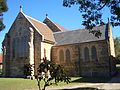 St Paul's Anglican Church
 -
 Resurrection of Christ Greek Orthodox Church


References[edit]
- ^ a b Australian Bureau of Statistics (28 June 2022). "Kogarah (State Suburb)". 2021 Census QuickStats. Retrieved 14 July 2022.
- ^ "History of Kogarah". Kogarah City Council. Retrieved 6 December 2013.
- ^ The Book of Sydney Suburbs, Compiled by Frances Pollon, Angus & Robertson Publishers, 1990, Published in Australia ISBN 0-207-14495-8, page 142
- ^ "OBITUARY". The Northern Standard. Darwin, NT: National Library of Australia. 23 July 1935. p. 10. Retrieved 2 September 2012.
- ^ Pictorial Memories. ST. GEORGE: Rockdale, Kogarah, Hurstville Joan Lawrence, Kingsclear Books, 1996, Published in Australia ISBN 0-908272-45-6
- ^ "Toomevara Lane Chinese Market Gardens". New South Wales State Heritage Register. Department of Planning & Environment. H01394. Retrieved 18 May 2018.
 Text is licensed by State of New South Wales (Department of Planning and Environment) under CC-BY 4.0 licence.
- ^ "Steve Smith". Wisden. Retrieved 8 April 2020.
External links[edit]
- Georges River Council website
- Bayside Council website
- Kogarah Marist High School
- St George Girls High School
- 2001 Census Information
33°58′03″S 151°08′11″E / 33.96740°S 151.13648°E
| International | |
|---|---|
| National | |