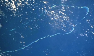
Lihou Reef National Nature Reserve
17°12′S 152°00′E / 17.200°S 152.000°E
This article needs to be updated. (July 2015) |

Lihou Reef National Nature Reserve is a former marine protected area covering an area of 8440 km2 in the Australian Coral Sea Islands Territory that was incorporated into the new Coral Sea Commonwealth Marine Reserve in December 2012.[1] Together with the Coringa-Herald National Nature Reserve, from which it is separated by about 100 km of open ocean, it forms the Coral Sea Reserves Ramsar Site, designated on 16 August 2002, listing it under the Ramsar Convention as a wetland of international importance.[2]
History
[edit]Lihou Reef and its cays were discovered by Lieutenant John Lihou, R.N., on 23 February 1823. Lihou, then Master of the brig-sloop HMS Zenobia, was on passage from Manila to South America. After a hazardous passage through the reef, the ship departed the Great Barrier Reef via an opening near Murray Islands. On 23 February, the Lihou Reefs were sighted.[3]
Description
[edit] | |
| Location | Lihou Reefs, Coral Sea Islands, Australia |
|---|---|
| Coordinates | 17°08′28″S 152°08′21″E / 17.14111°S 152.139222°E |
| Tower | |
| Foundation | four concrete piles |
| Construction | metal skeletal tower lower part, fiberglass tower upper part[4][5] |
| Height | 34 m (112 ft) |
| Shape | two-stage tower: quadrangular skeletal tower with balcony lower part, quadrangular tower with balcony upper part |
| Markings | white skeletal lower tower, red upper tower |
| Power source | solar power |
| Operator | Australian Maritime Safety Authority |
| Light | |
| Focal height | 33 m (108 ft) |
| Range | 19 nmi (35 km; 22 mi) |
| Characteristic | Fl W 10s |
Lihou Reef is the second largest atoll by total size in the Coral Sea, after the Chesterfield Islands (not counting the completely submerged Lansdowne Bank in the easternmost reaches of the Coral Sea). It is U-shaped, with an opening in the south-west. The size of the lagoon is about 100 by 30 km, with an area of 2529 km2, making the atoll one of the largest in the world. Nevertheless, the total land area of the islets and cays is little more than a square kilometre. The lagoon is up to 60 m deep. The reserve contains 18 islets and cays, 9 each on the Northern Rim and the Southern Rim, ranging in size from 5,000 to 168,000 m2.
Northern Rim
[edit]Total land area 560,000 m2; the islets on the Northern Rim are, from southwest to northeast (clockwise):
- Juliette Cay (78,000 m2)
- Kathy Cay (40,000 m2)
- Lorna Cay (168,000 m2)
- Little Margaret Cay (10,000 m2)
- Margaret Cay (30,000 m2)
- Turtle Islet (31,000 m2)
- Middle Cay (78,000 m2)
- Observatory Cay (88,000 m2)
- Licklick Cay (40,000 m2)
Only Lorna Cay and Turtle Islet are vegetated. Turtle Islet reaches a height of 6 m, and Observatory Cay 2 m.
Southern Rim
[edit]Total land area 470,000 m2.
The islets on the Southern Rim are, from northeast to southwest (clockwise):
- Anne Cay, "No 1 Cay" (112,000 m2)
- Betty Cay, "No 2 Cay" (37,000 m2)
- Carol Cay, "No 3 Cay" (5,000 m2)
- Dianna Cay, "No 4 Cay" (16,000 m2)
- Fanny Cay, "No 5 Cay" (7,000 m2)
- Edna Cay, "No 6 Cay" (73,000 m2)
- Helen Cay, "No 7 Cay" (10,000 m2)
- Georgina Cay, "No 8 Cay" (105,000 m2)
- Nellie Cay, "No 9 Cay" (104,000 m2)
Only the largest three of the Southern Rim, Anne Cay, Georgina Cay and Nellie Cay, are vegetated. Just northeast of Anne Cay is the Herald Passage into the lagoon.
References
[edit]- ^ "Environment Protection and Biodiversity Conservation (Commonwealth Marine Reserves) Proclamation 2012 - F2012L02188". Commonwealth of Australia, Comlaw. Retrieved 19 March 2015.
- ^ "The Annotated Ramsar List: Australia". The Ramsar Convention on Wetlands. 4 January 2000. Archived from the original on 19 September 2011. Retrieved 29 March 2010.
- ^ Source: Hydrographic Service - Royal Australian Navy. (M.A. BOLGER. Lieutenant Commander RAN for DIRECTOR HYDROGRAPHIC OFFICE. 19 July 1985)
- ^ Rowlett, Russ. "Lighthouses of Australia: Coral Sea Islands Territory". The Lighthouse Directory. University of North Carolina at Chapel Hill. Retrieved 7 November 2016.
- ^ NGA List of Lights – Pub.111 Retrieved 7 November 2016
External links
[edit]- More pictures at the Wayback Machine (archived December 23, 2010)
