
List of longest streams of Idaho

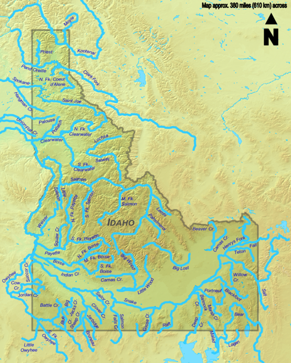
A total of seventy streams that are at least 50 miles (80 km) long flow through the U.S. state of Idaho. All of these streams originate in the United States except the Kootenai River (third-longest) and the Moyie River (thirty-first-longest), both of which begin in the Canadian province of British Columbia. At 1,076 miles (1,732 km), the Snake River is the longest and the only stream of more than 500 miles (800 km) in total length. It begins in Wyoming and flows through Idaho for 769 miles (1,238 km), and then through Oregon and Washington. Some of the other streams also cross borders between Idaho and Montana, Nevada, Oregon, Utah, Washington, or Wyoming, but the majority flow entirely within Idaho, the longest of which is the Salmon River at 425 miles (684 km).
All but four of the streams lie within the large basin of the Columbia River, although the river itself does not flow through Idaho. Consequently, the predominant direction of the state's streamflow is northwest towards the Columbia River and its mouth at the Pacific Ocean. The only other major drainage basin in Idaho is the Great Salt Lake watershed in the state's southeastern corner, which is part of the Great Basin and has no outlet to the ocean. The Bear River, the second-longest stream, is within this watershed, along with the Malad River, Deep Creek, and the Logan River.
Source data for the table below comes from topographic maps created by the United States Geological Survey and published online by TopoQuest, and on the Idaho Road and Recreation Atlas, the National Hydrography Dataset, the Geographic Names Information System, and other sources as noted. In the table, total lengths are given in miles (mi) and kilometers (km).
Table[edit]


Map[edit]
See also[edit]
- List of rivers of Idaho
- List of longest rivers in the United States by state
- List of longest rivers of the United States (by main stem)
Notes[edit]
- ^ a b Approximation; Goose Creek's course is largely obliterated by agriculture past Lower Goose Creek Reservoir.
- ^ a b Approximation; Willow Creek's course is largely obliterated by agriculture past Ririe.
- ^ All of the Salt River's length within Idaho is submerged by Palisades Reservoir.
- ^ a b Length includes Priest Lake. The Priest River is 47 mi (76 km) long not including Priest Lake.
References[edit]
- ^ United States Geological Survey. United States Geological Survey Topographic Map (Topographic map). Reston, VA: United States Geological Survey – via TopoQuest.
- ^ Benchmark Maps 2010.
- ^ a b Stream lengths are derived from high-resolution flowline data from the National Hydrography Dataset (NHD) unless otherwise noted. Idaho NHD data may be downloaded here [permanent dead link] (453 MB zip file).
- ^ a b The mouth coordinates, mouth elevation, and source coordinates are from the Geographic Names Information System (United States Geological Survey) listing for each stream except the Kootenai River (Canadian topographic maps) and the Moyie River (Canadian Geographical Names Data Base).
- ^ "Snake River". Geographic Names Information System. United States Geological Survey. September 10, 1979. Retrieved August 6, 2010.
- ^ "Bear River". Geographic Names Information System. United States Geological Survey. December 31, 1979. Retrieved January 29, 2012.
- ^ "Rivers". Atlas of Canada. October 25, 2010. Archived from the original on January 22, 2013. Retrieved July 17, 2013.
- ^ "Kootenai River". Geographic Names Information System. United States Geological Survey. Retrieved April 15, 2011.
- ^ Source coordinates derived from Google Earth using data from Canadian topographic maps.
- ^ "Salmon River". Geographic Names Information System. United States Geological Survey. June 21, 1979. Retrieved January 29, 2012.
- ^ "Owyhee River". Geographic Names Information System. United States Geological Survey. November 28, 1980. Retrieved August 13, 2010.
- ^ "Clark Fork". Geographic Names Information System. United States Geological Survey. June 21, 1979. Retrieved April 19, 2011.
- ^ "Palouse River". Geographic Names Information System. United States Geological Survey. September 10, 1979. Retrieved April 24, 2011.
- ^ "Bruneau River". Geographic Names Information System. United States Geological Survey. June 21, 1979. Retrieved February 17, 2012.
- ^ "Saint Joe River". Geographic Names Information System. United States Geological Survey. June 21, 1979. Retrieved July 2, 2012.
- ^ "Big Wood River". Geographic Names Information System. United States Geological Survey. June 21, 1979. Retrieved February 17, 2012.
- ^ "Big Lost River". Geographic Names Information System. United States Geological Survey. June 21, 1979. Retrieved February 18, 2012.
- ^ "Blackfoot River". Geographic Names Information System. United States Geological Survey. June 21, 1979. Retrieved February 18, 2012.
- ^ "North Fork Clearwater River". Geographic Names Information System. United States Geological Survey. June 21, 1979. Retrieved April 28, 2011.
- ^ "Little Wood River". Geographic Names Information System. United States Geological Survey. June 21, 1979. Retrieved February 18, 2012.
- ^ "Henrys Fork". Geographic Names Information System. United States Geological Survey. June 21, 1979. Retrieved July 8, 2012.
- ^ "South Fork Owyhee River". Geographic Names Information System. United States Geological Survey. June 21, 1979. Retrieved February 18, 2012.
- ^ "Portneuf River". Geographic Names Information System. United States Geological Survey. June 21, 1979. Retrieved July 8, 2012.
- ^ "Goose Creek". Geographic Names Information System. United States Geological Survey. June 21, 1979. Retrieved August 17, 2012.
- ^ "Salmon Falls Creek". Geographic Names Information System. United States Geological Survey. June 21, 1979. Retrieved February 18, 2012.
- ^ "Pend Oreille River". Geographic Names Information System. United States Geological Survey. Retrieved April 19, 2011.
- ^ "Spokane River". Geographic Names Information System. United States Geological Survey. September 10, 1979. Retrieved April 19, 2011.
- ^ "Raft River". Geographic Names Information System. United States Geological Survey. June 21, 1979. Retrieved July 8, 2012.
- ^ "Middle Fork Salmon River". Geographic Names Information System. United States Geological Survey. June 21, 1979. Retrieved July 2, 2012.
- ^ "North Fork Payette River". Geographic Names Information System. United States Geological Survey. June 21, 1979. Retrieved July 2, 2012.
- ^ "Weiser River". Geographic Names Information System. United States Geological Survey. June 21, 1979. Retrieved July 2, 2012.
- ^ "Boise River". Geographic Names Information System. United States Geological Survey. June 21, 1979. Retrieved July 2, 2012.
- ^ "South Fork Boise River". Geographic Names Information System. United States Geological Survey. June 21, 1979. Retrieved July 2, 2012.
- ^ "Selway River". Geographic Names Information System. United States Geological Survey. June 21, 1979. Retrieved July 2, 2012.
- ^ "Jordan Creek". Geographic Names Information System. United States Geological Survey. November 28, 1980. Retrieved August 28, 2010.
- ^ "Malad River". Geographic Names Information System. United States Geological Survey. December 31, 1979. Retrieved July 2, 2012.
- ^ "Big Malad Spring". Geographic Names Information System. United States Geological Survey. June 21, 1979. Retrieved July 22, 2013.
- ^ "Moyie River". Geographic Names Information System. United States Geological Survey. June 21, 1979.
- ^ "Moyie River". BC Geographical Names. Retrieved April 16, 2011.
- ^ "South Fork Salmon River". Geographic Names Information System. United States Geological Survey. June 21, 1979. Retrieved July 4, 2012.
- ^ "Willow Creek". Geographic Names Information System. United States Geological Survey. June 21, 1979. Retrieved August 17, 2012.
- ^ "Salt River". Geographic Names Information System. United States Geological Survey. June 5, 1979. Retrieved July 4, 2012.
- ^ "Payette River". Geographic Names Information System. United States Geological Survey. December 31, 1992. Retrieved July 4, 2012.
- ^ "Teton River". Geographic Names Information System. United States Geological Survey. June 21, 1979. Retrieved July 5, 2012.
- ^ "South Fork Payette River". Geographic Names Information System. United States Geological Survey. June 21, 1979. Retrieved July 5, 2012.
- ^ "Hangman Creek". Geographic Names Information System. United States Geological Survey. September 10, 1979. Retrieved April 22, 2011.
- ^ "North Fork Coeur d'Alene River". Geographic Names Information System. United States Geological Survey. May 1, 1991. Retrieved July 5, 2012.
- ^ "Clearwater River". Geographic Names Information System. United States Geological Survey. June 21, 1979. Retrieved April 25, 2011.
- ^ "Deep Creek". Geographic Names Information System. United States Geological Survey. June 21, 1979. Retrieved July 5, 2012.
- ^ "Union Flat Creek". Geographic Names Information System. United States Geological Survey. September 10, 1979. Retrieved July 5, 2012.
- ^ "Succor Creek". Geographic Names Information System. United States Geological Survey. November 28, 1980. Retrieved August 31, 2010.
- ^ "Lochsa River". Geographic Names Information System. United States Geological Survey. June 21, 1979. Retrieved July 5, 2012.
- ^ "Priest River". Geographic Names Information System. United States Geological Survey. June 21, 1979. Retrieved August 17, 2012.
- ^ "Battle Creek". Geographic Names Information System. United States Geological Survey. June 21, 1979. Retrieved July 5, 2012.
- ^ "Bannock Creek". Geographic Names Information System. United States Geological Survey. June 21, 1979. Retrieved July 5, 2012.
- ^ "Indian Creek". Geographic Names Information System. United States Geological Survey. June 21, 1979. Retrieved July 5, 2012.
- ^ "Sailor Creek". Geographic Names Information System. United States Geological Survey. June 21, 1979. Retrieved July 7, 2012.
- ^ "Fall River". Geographic Names Information System. United States Geological Survey. December 31, 1992. Retrieved July 7, 2012.
- ^ "Camas Creek". Geographic Names Information System. United States Geological Survey. June 21, 1979. Retrieved July 7, 2012.
- ^ "Camas Creek". Geographic Names Information System. United States Geological Survey. June 21, 1979. Retrieved July 7, 2012.
- ^ "South Fork Clearwater River". Geographic Names Information System. United States Geological Survey. June 21, 1979. Retrieved April 26, 2011.
- ^ "Sheep Creek". Geographic Names Information System. United States Geological Survey. June 21, 1979. Retrieved July 7, 2012.
- ^ "Chief Eagle Eye Creek". Geographic Names Information System. United States Geological Survey. June 21, 1979. Retrieved July 7, 2012.
- ^ "Little Owyhee River". Geographic Names Information System. United States Geological Survey. June 21, 1979. Retrieved July 7, 2012.
- ^ "Lemhi River". Geographic Names Information System. United States Geological Survey. June 21, 1979. Retrieved July 7, 2012.
- ^ "Pahsimeroi River". Geographic Names Information System. United States Geological Survey. June 21, 1979. Retrieved July 7, 2012.
- ^ "Beaver Creek". Geographic Names Information System. United States Geological Survey. June 21, 1979. Retrieved July 8, 2012.
- ^ "Big Jacks Creek". Geographic Names Information System. United States Geological Survey. December 31, 1992. Retrieved July 8, 2012.
- ^ "Potlatch River". Geographic Names Information System. United States Geological Survey. June 21, 1979. Retrieved April 25, 2011.
- ^ "Marsh Creek". Geographic Names Information System. United States Geological Survey. June 21, 1979. Retrieved July 8, 2012.
- ^ "Clover Creek". Geographic Names Information System. United States Geological Survey. June 21, 1979. Retrieved July 8, 2012.
- ^ "Logan River". Geographic Names Information System. United States Geological Survey. June 21, 1979. Retrieved July 8, 2012.
- ^ "Blue Creek". Geographic Names Information System. United States Geological Survey. June 21, 1979. Retrieved July 8, 2012.
- ^ "Middle Fork Boise River". Geographic Names Information System. United States Geological Survey. June 21, 1979. Retrieved July 8, 2012.
- ^ "Little Salmon River". Geographic Names Information System. United States Geological Survey. June 21, 1979. Retrieved July 8, 2012.
- ^ "Jarbidge River". Geographic Names Information System. United States Geological Survey. June 21, 1979. Retrieved July 8, 2012.
- ^ "Cow Creek". Geographic Names Information System. United States Geological Survey. November 28, 1980. Retrieved September 3, 2010.
- ^ "North Fork Boise River". Geographic Names Information System. United States Geological Survey. June 21, 1979. Retrieved July 8, 2012.
Works cited[edit]
- Benchmark Maps (2010). Idaho Road and Recreation Atlas (Map) (2nd ed.). 1:250,000. Benchmark Maps. ISBN 978-0-929591-06-3. OCLC 567571371.
External links[edit]
- Map of Idaho streams published by the Idaho Department of Environmental Quality