From Wikipedia, the free encyclopedia
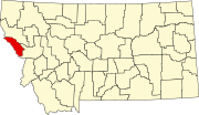
Location of Mineral County in Montana This is a list of the National Register of Historic Places listings in Mineral County, Montana .
This is intended to be a complete list of the properties and districts on the National Register of Historic Places in Mineral County , Montana , United States . The locations of National Register properties and districts for which the latitude and longitude coordinates are included below, may be seen in a map.[ 1]
There are 18 properties and districts listed on the National Register in the county.
This National Park Service list is complete through NPS recent listings posted November 1, 2024. [ 2]
[ 3] Name on the Register
Image
Date listed[ 4]
Location
City or town
Description
1
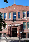
Alberton School Alberton School January 13, 1997 (#96001599 ) 216 Railroad Street 47°00′17″N 114°28′50″W / 47.004722°N 114.480556°W / 47.004722; -114.480556 (Alberton School ) Alberton
2
Bestwick's Market Bestwick's Market January 13, 1997 (#96001600 ) Railroad Street east of its junction with Interstate 90 47°00′13″N 114°28′36″W / 47.003611°N 114.476667°W / 47.003611; -114.476667 (Bestwick's Market ) Alberton
3
Brinks House Brinks House January 13, 1997 (#96001601 ) 416 Railroad Street 47°00′14″N 114°28′42″W / 47.003889°N 114.478333°W / 47.003889; -114.478333 (Brinks House ) Alberton
4
Chadwick House Chadwick House January 13, 1997 (#96001602 ) 320 Railroad Street 47°00′15″N 114°28′45″W / 47.004167°N 114.479167°W / 47.004167; -114.479167 (Chadwick House ) Alberton
5
Chicago, Milwaukee, St. Paul and Pacific Railroad Company Historic District Chicago, Milwaukee, St. Paul and Pacific Railroad Company Historic District October 26, 2000 (#00001269 ) Idaho Panhandle National Forest 47°21′46″N 115°39′30″W / 47.362778°N 115.658333°W / 47.362778; -115.658333 (Chicago, Milwaukee, St. Paul and Pacific Railroad Company Historic District ) St. Regis
6
De Borgia Schoolhouse De Borgia Schoolhouse December 27, 1979 (#79001405 ) Thompson Falls De Borgia Rd. 47°22′50″N 115°20′49″W / 47.380556°N 115.346944°W / 47.380556; -115.346944 (De Borgia Schoolhouse ) De Borgia
7
Gildersleeve Mine Gildersleeve Mine June 26, 2002 (#02000723 ) Lolo National Forest 47°02′09″N 115°02′04″W / 47.035833°N 115.034444°W / 47.035833; -115.034444 (Gildersleeve Mine ) Superior
8
Methodist Church of Alberton Methodist Church of Alberton January 13, 1997 (#96001604 ) 802 Railroad Street 47°00′10″N 114°28′26″W / 47.002778°N 114.473889°W / 47.002778; -114.473889 (Methodist Church of Alberton ) Alberton
9
Railroad Depot Railroad Depot January 13, 1997 (#96001603 ) 701 Railroad Street 47°00′10″N 114°28′30″W / 47.002778°N 114.475°W / 47.002778; -114.475 (Railroad Depot ) Alberton
10
Natural Pier Bridge Natural Pier Bridge January 4, 2010 (#09001182 ) Milepost 1 on S. Frontage Rd. 47°00′50″N 114°30′28″W / 47.013942°N 114.507642°W / 47.013942; -114.507642 (Natural Pier Bridge ) Alberton
11
Point of Rocks Historic Transportation Corridor Point of Rocks Historic Transportation Corridor September 4, 2009 (#09000683 ) 2 miles (3.2 km) west of Alberton 47°00′42″N 114°32′52″W / 47.011667°N 114.547778°W / 47.011667; -114.547778 (Point of Rocks Historic Transportation Corridor ) Alberton
12
St. Regis Airway Beacon Upload image November 8, 2021 (#100007145 ) 2 miles (3.2 km) SE of St. Regis 47°17′14″N 115°03′02″W / 47.2871°N 115.0505°W / 47.2871; -115.0505 (St. Regis Airway Beacon ) St. Regis vicinity
13
Savenac Nursery Historic District Savenac Nursery Historic District August 16, 1999 (#99000988 ) Interstate 90 south of Haugan47°23′07″N 115°23′47″W / 47.385278°N 115.396389°W / 47.385278; -115.396389 (Savenac Nursery Historic District ) Haugan
14
Scenic Bridge Scenic Bridge January 4, 2010 (#09001183 ) Milepost 0 on Old U.S. Route 10 W. 47°01′12″N 114°39′27″W / 47.020092°N 114.657436°W / 47.020092; -114.657436 (Scenic Bridge ) Tarkio
15
Superior School Superior School March 21, 1997 (#97000253 ) River Road, approximately 0.25 miles (0.40 km) north of Interstate 90 47°11′42″N 114°53′25″W / 47.194923°N 114.890301°W / 47.194923; -114.890301 (Superior School ) Superior School built during 1915-16, with vernacular and Colonial Revival style.
16
Swanson Homestead Upload image November 22, 2022 (#100008425 ) Approx. 12 miles (19 km) south of Superior Coordinates missing
Superior vicinity
17
Thorn House Upload image January 13, 1997 (#96001605 ) 140 2nd Street 47°00′19″N 114°28′54″W / 47.005278°N 114.481667°W / 47.005278; -114.481667 (Thorn House ) Alberton
18
Wilson House Wilson House January 13, 1997 (#96001606 ) 114 Adams Street 47°00′06″N 114°28′14″W / 47.001667°N 114.470556°W / 47.001667; -114.470556 (Wilson House ) Alberton
^ The latitude and longitude information provided in this table was derived originally from the National Register Information System, which has been found to be fairly accurate for about 99% of listings. Some locations in this table may have been corrected to current GPS standards.
^ National Park Service, United States Department of the Interior , "National Register of Historic Places: Weekly List Actions" , retrieved November 1, 2024.
^ Numbers represent an alphabetical ordering by significant words. Various colorings, defined here , differentiate National Historic Landmarks and historic districts from other NRHP buildings, structures, sites or objects.
^ The eight-digit number below each date is the number assigned to each location in the National Register Information System database, which can be viewed by clicking the number.


