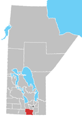
Municipality of Rhineland
Rhineland | |
|---|---|
| Municipality of Rhineland | |
 Location of the RM of Rhineland in Manitoba | |
| Coordinates: 49°07′59″N 97°35′39″W / 49.13306°N 97.59417°W | |
| Country | Canada |
| Province | Manitoba |
| Region | Pembina Valley |
| Incorporated (amalgamated) | January 1, 2015[2] |
| Population (2016) | |
| • Total | 5,945[1] |
| Time zone | UTC-6 (CST) |
| • Summer (DST) | UTC-5 (CDT) |
| Website | rmofrhineland |
The Municipality of Rhineland is a rural municipality (RM) in the Pembina Valley Region of Manitoba. The RM had a population of 5,945 as of the 2016 Canada Census.[1] The average age in the municipality is 31.[3]
It surrounds, but does not include, the Town of Altona.
History
[edit]The municipality was incorporated on January 1, 2015, via the amalgamation of the Rural Municipality of Rhineland and the towns of Gretna and Plum Coulee.[2][4] It was formed as a requirement of The Municipal Amalgamations Act, which required municipalities with a population less than 1,000 to amalgamate with one or more neighbouring municipalities by 2015.[5] The Government of Manitoba initiated the amalgamations for municipalities to meet the 1997 minimum population requirement of 1,000 to incorporate a municipality.[6]
The original RM of Rhineland was incorporated as a rural municipality on February 14, 1880, along with the neighbouring RM of Douglas, which was absorbed into Rhineland in February 1891.[4]
In 1882, the community of Rosenfeld was founded in the RM as a CPR station. Though becoming an unincorporated village in 1949, it was later turned into a Local Urban District in Rhineland in 1996 with the rewriting of the Manitoba Municipal Act, and exists as an LUD to this day.[7]
Rhineland takes its name after a district in the Rhine valley in western Germany.[4]
Communities
[edit]- Blumenort South
- Gnadenfeld
- Gnadenthal
- Gretna
- Halbstadt
- Horndean
- Kronsthal
- Neubergthal
- Neuhorst
- Plum Coulee
- Rosenfeld
- Rosengart
- Rosetown
- Schoenwiese
- Sommerfeld
Demographics
[edit]In the 2021 Census of Population conducted by Statistics Canada, Rhineland had a population of 5,819 living in 1,641 of its 1,748 total private dwellings, a change of -2.1% from its 2016 population of 5,945. With a land area of 958.48 km2 (370.07 sq mi), it had a population density of 6.1/km2 (15.7/sq mi) in 2021.[8]
See also
[edit]References
[edit]- ^ a b "Census Profile, 2016". Statistics Canada. Retrieved July 26, 2021.
- ^ a b "The Municipal Amalgamations Act (C.C.S.M. c. M235): Town of Plum Coulee, Rural Municipality of Rhineland and Town of Gretna Amalgamation Regulation" (PDF). Government of Manitoba. Retrieved October 4, 2014.
- ^ Government of Canada, Statistics Canada (February 9, 2022). "2021 Census of Population geographic summary: Rhineland, Municipality (MU) [Census subdivision], Manitoba". www12.statcan.gc.ca. Retrieved September 15, 2024.
- ^ a b c "Manitoba Communities: Rhineland (Municipality)". www.mhs.mb.ca. Retrieved September 15, 2024.
- ^ "The Municipal Amalgamations Act (C.C.S.M. c. M235)". Government of Manitoba. October 2, 2014. Retrieved October 4, 2014.
- ^ "Speech from the Throne: At the Opening of the Second Session of the 40th Legislature of the Province of Manitoba". Government of Manitoba. November 19, 2012. Retrieved October 4, 2014.
- ^ "Manitoba Communities: Rosenfeld (Unincorporated Village, Municipality of Rhineland)". www.mhs.mb.ca. Retrieved September 15, 2024.
- ^ "Population and dwelling counts: Canada, provinces and territories, and census subdivisions (municipalities), Manitoba". Statistics Canada. February 9, 2022. Retrieved February 20, 2022.

