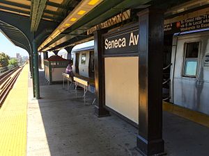
Seneca Avenue station
Seneca Avenue | |||||||||||||||||||||||||||||||||||||||||||||||||||||||||||||||||||||||||||
|---|---|---|---|---|---|---|---|---|---|---|---|---|---|---|---|---|---|---|---|---|---|---|---|---|---|---|---|---|---|---|---|---|---|---|---|---|---|---|---|---|---|---|---|---|---|---|---|---|---|---|---|---|---|---|---|---|---|---|---|---|---|---|---|---|---|---|---|---|---|---|---|---|---|---|---|
 | |||||||||||||||||||||||||||||||||||||||||||||||||||||||||||||||||||||||||||
| Station statistics | |||||||||||||||||||||||||||||||||||||||||||||||||||||||||||||||||||||||||||
| Address | Seneca Avenue & Palmetto Street Queens, New York | ||||||||||||||||||||||||||||||||||||||||||||||||||||||||||||||||||||||||||
| Borough | Queens | ||||||||||||||||||||||||||||||||||||||||||||||||||||||||||||||||||||||||||
| Locale | Ridgewood | ||||||||||||||||||||||||||||||||||||||||||||||||||||||||||||||||||||||||||
| Coordinates | 40°42′10″N 73°54′28″W / 40.702765°N 73.907733°W | ||||||||||||||||||||||||||||||||||||||||||||||||||||||||||||||||||||||||||
| Division | B (BMT)[1] | ||||||||||||||||||||||||||||||||||||||||||||||||||||||||||||||||||||||||||
| Line | BMT Myrtle Avenue Line | ||||||||||||||||||||||||||||||||||||||||||||||||||||||||||||||||||||||||||
| Services | M | ||||||||||||||||||||||||||||||||||||||||||||||||||||||||||||||||||||||||||
| Transit | |||||||||||||||||||||||||||||||||||||||||||||||||||||||||||||||||||||||||||
| Structure | Elevated | ||||||||||||||||||||||||||||||||||||||||||||||||||||||||||||||||||||||||||
| Platforms | 1 island platform | ||||||||||||||||||||||||||||||||||||||||||||||||||||||||||||||||||||||||||
| Tracks | 2 | ||||||||||||||||||||||||||||||||||||||||||||||||||||||||||||||||||||||||||
| Other information | |||||||||||||||||||||||||||||||||||||||||||||||||||||||||||||||||||||||||||
| Opened | February 22, 1915 | ||||||||||||||||||||||||||||||||||||||||||||||||||||||||||||||||||||||||||
| Closed | July 1, 2017 (temporary line closure) | ||||||||||||||||||||||||||||||||||||||||||||||||||||||||||||||||||||||||||
| Reopened | September 1, 2017 | ||||||||||||||||||||||||||||||||||||||||||||||||||||||||||||||||||||||||||
| Opposite- direction transfer | Yes | ||||||||||||||||||||||||||||||||||||||||||||||||||||||||||||||||||||||||||
| Traffic | |||||||||||||||||||||||||||||||||||||||||||||||||||||||||||||||||||||||||||
| 2023 | 617,361[2] | ||||||||||||||||||||||||||||||||||||||||||||||||||||||||||||||||||||||||||
| Rank | 357 out of 423[2] | ||||||||||||||||||||||||||||||||||||||||||||||||||||||||||||||||||||||||||
| |||||||||||||||||||||||||||||||||||||||||||||||||||||||||||||||||||||||||||
| |||||||||||||||||||||||||||||||||||||||||||||||||||||||||||||||||||||||||||
| |||||||||||||||||||||||||||||||||||||||||||||||||||||||||||||||||||||||||||
| |||||||||||||||||||||||||||||||||||||||||||||||||||||||||||||||||||||||||||
| |||||||||||||||||||||||||||||||||||||||||||||||||||||||||||||||||||||||||||
The Seneca Avenue station is a station on the BMT Myrtle Avenue Line of the New York City Subway. Located at the intersection of Palmetto Street and Seneca Avenue in Ridgewood, Queens, it is served by the M train at all times. The station opened in 1915 as part of the Dual Contracts.
History
[edit]This station opened on February 22, 1915, by the Brooklyn Rapid Transit Company as part of a project to elevate a portion of the Myrtle Avenue Line, which had run at street level. This work was completed as part of the Dual Contracts.[3][4][5]
Station layout
[edit]| Platform level | Westbound | ← |
| Island platform | ||
| Eastbound | | |
| Mezzanine | Fare control, station agent, MetroCard and OMNY machines | |
| Ground | Street level | Exit/entrance |
This elevated station has two tracks and an island platform. The platform has a steel canopy supported by black and green columns in the center.

To the northeast (railroad south) of the station, the BMT Myrtle Avenue Line curves east to leave the street grid and continue as an elevated structure over the former grade level steam dummy Lutheran Cemetery Line. Southwest of the station, there is space for a center track.
Exits
[edit]The station's only entrance/exit is an elevated wooden mezzanine beneath the tracks. It has two staircases to the platform with doors on the landings, turnstile bank, token booth, and two street stairs to the southwest and northeast corners of Palmetto Street and Seneca Avenue.[6]
References
[edit]- ^ "Glossary". Second Avenue Subway Supplemental Draft Environmental Impact Statement (SDEIS) (PDF). Vol. 1. Metropolitan Transportation Authority. March 4, 2003. pp. 1–2. Archived from the original (PDF) on February 26, 2021. Retrieved January 1, 2021.
- ^ a b "Annual Subway Ridership (2018–2023)". Metropolitan Transportation Authority. 2023. Retrieved April 20, 2024.
- ^ Roess, Roger P.; Sansone, Gene (August 23, 2012). The Wheels That Drove New York: A History of the New York City Transit System. Springer Science & Business Media. ISBN 9783642304842.
- ^ "Article 11 -- No Title" (PDF). The New York Times. Retrieved March 27, 2016.
- ^ Senate, New York (State) Legislature (1916). Documents of the Senate of the State of New York. E. Croswell.
- ^ "MTA Neighborhood Maps: Ridgewood" (PDF). mta.info. Metropolitan Transportation Authority. 2015. Retrieved July 20, 2016.
External links
[edit] Media related to Seneca Avenue (BMT Myrtle Avenue Line) at Wikimedia Commons
- nycsubway.org – BMT Myrtle Avenue Line: Seneca Avenue
- Station Reporter — M Train
- The Subway Nut — Seneca Avenue Pictures
- Seneca Avenue entrance from Google Maps Street View
- Platform from Google Maps Street View


