
Sugarloaf (New Zealand)
This article needs additional citations for verification. (September 2021) |
| Sugarloaf communications tower | |
|---|---|
 Sugarloaf communications tower viewed from the car park off Summit Road | |
| Highest point | |
| Elevation | 493.78 m (1,620.0 ft) |
| Coordinates | 43°36′12″S 172°38′58″E / 43.603244°S 172.649534°E |
| Naming | |
| Native name | Te Heru o Kahukura (Māori) |
| Geography | |
 Te Heru o Kahukura / Sugarloaf Location in Christchurch, New Zealand | |
| Location | Christchurch, New Zealand |
| Geology | |
| Mountain type | Basalt volcanic rock |
Sugarloaf (Māori: Te Heru o Kahukura) is a hill in the Port Hills, 8 km (5.0 mi) south of central Christchurch in New Zealand. The hill is home to the main television and FM radio transmitter for Christchurch and the wider Canterbury region.
Etymology
[edit]Te Heru o Kahukura, the Māori name for Sugarloaf, translates as "the headcomb of Kahukura".[1]
Geography
[edit]The tower is situated at an elevation of 493.78 m on the top of the Port Hills, near Dyers Pass. This area is officially known as Sugarloaf Scenic Reserve. This reserve land occasionally doubles as a sheep farm and includes a car park lookout point for general public use.
Communications tower
[edit]In 1962, the New Zealand Broadcasting Corporation leased a 4.9ha section of the reserve from the Crown on the summit of Sugarloaf Hill to install and operate a television communications tower and control building.[2] The tower and building were completed in 1965. Television channel CHTV3 (now part of TVNZ 1) started transmitting from the tower at 9:00 AM on 28 August 1965.[3] In 1975, new aerials were installed on the tower for TV2 (now TVNZ 2). However, an aerial fault caused loss of reception to northwestern Christchurch and the channel's launch in the city on 30 June 1975 was delayed to 6:00pm to give engineers extra time to repair the fault.[4][5] FM radio broadcasting from the tower began on 31 May 1986, with 3ZM broadcasting on 91.3 MHz.[6]
With a height of 121 m, the lattice steel structured tower is founded on a 5-metre deep concrete pad underlain by basalt volcanic rock. It is situated approximately 50 m behind the main transmission building, which combined with the tower is visible from most parts of Christchurch city.
Transmission house
[edit]The tower is located 50 m behind a single storey transmission building which houses multiple transmission gear. The main equipment room is fully air conditioned and known to local technicians as the great transmitter hall. The building is approximately 40 m in width and 20 m in depth. On the roof of this building there are several satellites, small antennae and multiple parabolic dishes for private WiFi networks. There are two main shielded cable runs that go between the transmission house and back to the tower. This building has been unmanned for several years.[7]
Technical aspects
[edit]The main antennas transmit TV and VHF FM signals in the 88 MHz to 610 MHz range. The composite total power fed to all of the transmitting antennas is approximately 64 kW while the antenna gain values range from 7.8 to 16.5 dBd. Multiple services operate off the tower including television, radio, emergency response, aviation, cellular and other data signals.
The tower covers much of Christchurch and central Canterbury, for example the DVB-T signal reaches as far as Waipara in the north, the foothills of the Southern Alps in the west, and the Rangitata River in the south.[8] However, not all of the central Canterbury region is covered by this tower. The nearby township of Akaroa (and most of the settlements near Akaroa) have limited to non-existent TV reception and variable radio reception.Likewise, the Christchurch suburbs of Redcliffs and Sumner have limited coverage from Sugarloaf, with radio (and formerly analogue television) provided through a low-power repeater in the suburb of Southshore.
Transmission frequencies
[edit]This table contains television frequencies currently operating at Sugarloaf, and the FM broadcast frequencies are contained in this linked list of stations article:
| TV Channel | Transmit Channel | Transmit Frequency | Band | ERP (kW) |
|---|---|---|---|---|
| Kordia digital | 28 | 530 MHz | UHF | 50, horizontal |
| Sky digital | 30 | 546 MHz | UHF | 50, horizontal |
| Discovery NZ digital | 32 | 562 MHz | UHF | 50, horizontal |
| TVNZ digital | 34 | 578 MHz | UHF | 50, horizontal |
| Kordia digital | 36 | 594 MHz | UHF | 50, horizontal |
| Māori Television digital | 38 | 610 MHz | UHF | 50, horizontal |
Former analogue television frequencies
[edit]The following frequencies were used until 28 April 2013, when Sugarloaf switched off analogue broadcasts.[10]
| TV Channel | Transmit Channel | Transmit Frequency | Band | Power (kW) |
|---|---|---|---|---|
| TV One | 3 | 62.2396 MHz | VHF | 100 |
| TV3 | 6 | 189.2604 MHz | VHF | 320 |
| TV2 | 8 | 203.25 MHz | VHF | 320 |
| Four | 11 | 224.239575 MHz | VHF | 200 |
| CTV | 44 | 655.25 MHz | UHF | 25 |
| Māori Television | 46 | 671.2604 MHz | UHF | 320 |
| Prime | 62 | 799.25 MHz | UHF | 320 |
Case studies
[edit]An RF emissions report conducted on 9 February 1998 by the National Radiation Laboratory found that maximum exposure levels of 8 μW/cm2 were detected in the car park area, immediately below the Sugar Loaf antenna. This is 4% of the maximum of 200 μW/cm2 specified for public exposure levels in NZS 6609.1:1990. As the distance from the antenna increased, the exposure levels decreased markedly and, in general, were below 2 μW/cm2. The report concluded that the site is operating in accordance with NZS 6609.1:1990.
Gallery
[edit]-
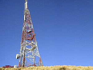 The Sugarloaf Communications tower stands 121 m high.
 -
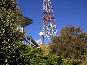 Sugarloaf Communications Tower showing cable runs from back of building to base of tower.
 -
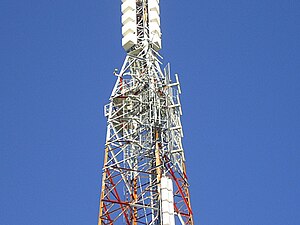 Close up view of Sugarloaf Communications Tower.
 -
 A gate prevents access to the transmitter site for private vehicles.
 -
 View of the tower from the carpark in 1990, showing old signage.
 -
 A close up of the tower base.
 -
 A survey point next to the Sugarloaf tower.
 -
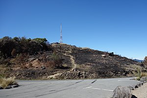 The Victoria Park fire close to the Sugarloaf tower.


Management
[edit]The tower and building are currently owned and maintained by Kordia, previously known as Broadcast Communications Limited (BCL NZ).
References
[edit]- ^ "Sugarloaf Circuit". ccc.govt.nz. Archived from the original on 24 July 2020. Retrieved 9 July 2020.
- ^ "TV STATION ON HILLS - 400 ft Tower Planned". The Press. 12 September 1962. p. 12. Archived from the original on 19 August 2022. Retrieved 19 August 2022.
- ^ "Sugarloaf To Open Tomorrow". The Press. 27 August 1965. p. 1. Archived from the original on 19 August 2022. Retrieved 19 August 2022.
- ^ "Power loss causes TV2 signal faults". The Press. 30 June 1975. p. 1. Archived from the original on 2 May 2024. Retrieved 5 October 2023.
- ^ "Bright new TV2 —and chance to twiddle knobs". The Press. 1 July 1975. p. 1. Archived from the original on 18 March 2024. Retrieved 5 October 2023.
- ^ "3ZM will go FM". The Press. 24 May 1986. p. 9. Archived from the original on 10 November 2023. Retrieved 10 November 2023.
- ^ Gates, Charlie (24 August 2018). "Sugarloaf: Inside the concrete eyrie high above Christchurch in the Port Hills". Stuff. Archived from the original on 1 March 2023. Retrieved 1 March 2023.
- ^ "Likely Coverage of Freeview Aerial (DTT) Service" (PDF). Kordia. March 2008. Archived (PDF) from the original on 19 April 2014. Retrieved 14 July 2013.
- ^ "RSM Register of Radio Frequencies". Archived from the original on 2 May 2024. Retrieved 18 December 2022.
- ^ "New Zealand Television Tramsmission Stations in Operation -- South Island" (PDF). Kordia. March 2008. Archived (PDF) from the original on 18 April 2013. Retrieved 16 July 2013.
External links
[edit]- Sugarloaf Communications Tower as seen in Google Maps
- Panorama View from Sugarloaf Scenic Reserve
- Christchurch City Council Reserve Information
- Port Hills Visitor Information
- Digital Switch Over Information for New Zealand 404
- 1998 RF Emissions Report for The Sugarloaf Communications Tower
- 2005 Tower Upgrade Contract
- Sugarloaf Scenic Reserve Dog Control Map
- Sugarloaf Freeview coverage
- Cashmere Spur and Bowenvale Valley Reserves
| International | |
|---|---|
| National | |