
User:Seoidau/Photos
(Redirected from User:Seo75/Photos)
Out and about
[edit]Redcliffe City, Queensland
[edit]-
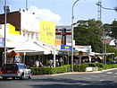
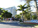 Entrance to the Scarborough Central Business District along Landsborough Parade
 -
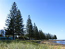 Scarborough Beach
 -
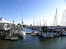 Scarborough Boat Harbour in the afternoon sun
 -
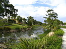
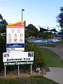 Settlement Cove lagoon in Redcliffe
 -
 Redcliffe Jetty, Redcliffe
 -
 Redcliffe central business district
 -
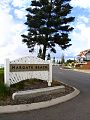 Entrance to Margate Beach, Margate
 -
 Humpybong Creek, Redcliffe
 -
 Evening traffic into Clontarf


Pine Rivers Shire, Queensland
[edit]-
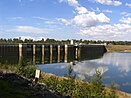 North Pine Dam at the precariously low level of 27%

Things
[edit]Animal
[edit]-
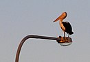 Pelican on a Houghton Highway light pole

Art and culture
[edit]-
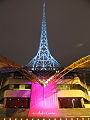 The Arts Centre spire, a Melbourne landmark
 -
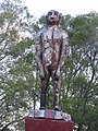 Wooden Yowie statue in Kilcoy, Queensland


Commerce and industry
[edit]-
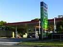 Caltex Woolworths service station in Margate, Queensland
 -
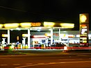 Coles Express service station in Clontarf, Queensland
 -
Typical fuel discount vouchers for use at Coles Express


Film and television
[edit]-
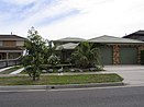 The Kath & Kim family home at Patterson Lakes, Victoria

Food stuffs
[edit]-
Cans of the former formulation of Mother energy drink produced by Coca-Cola Amatil
Infrastructure
[edit]-
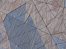 Federation Square's unmistakable sandstone building façade
 -
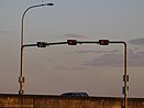
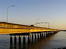 Houghton Highway in Queensland, Australia
 -
 Houghton Highway tidal flow system
 -
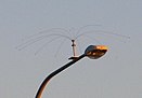 Daddi Long Legs bird deterrent on a Houghton Highway light pole


Transport
[edit]-
 Memorial cairn to commemorate the Camp Mountain train disaster, northwest of Brisbane
 -
-
 The abandoned Bunour railway station in 2007
 -
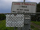 Sign of the then times (1993) at the abandoned Meeandah railway station in 2007
 -
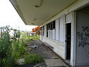
 The abandoned Meeandah railway station in 2007
 -
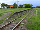
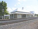
 A platform shot of disused Pinkenba railway station in 2007
 -
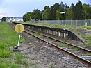
 Disused Pinkenba railway station in 2007, just 9 km from the Brisbane CBD
 -
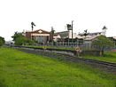
 Grandchester railway station, home of the world's first narrow gauge mainline railway


Mapping
[edit]Location
[edit]-
-
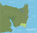 Suburb map of Woody Point, in the south-east of the Redcliffe peninsula
 -
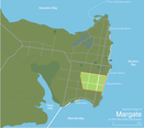 Suburb map of Margate, in the east of the Redcliffe peninsula
 -
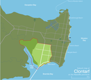 Suburb map of Clontarf, in the south-west of the Redcliffe peninsula
 -
 Suburb map of Rothwell, in the west of the Redcliffe peninsula
 -
 Suburb map of Kippa-Ring, at the center of the Redcliffe peninsula
 -
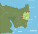 Suburb map of Redcliffe, in the north-east of the Redcliffe peninsula
 -
 Suburb map of Scarborough, at the northernmost of the Redcliffe peninsula
 -
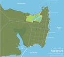 Suburb map of Newport, in the north of the Redcliffe peninsula


Transport
[edit]-
 Map of the West Gate Freeway, west of Melbourne
 -
 Map of the Eastern Freeway, east of Melbourne
 -
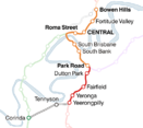
 Map of the South-East Busway, Brisbane
 -
 Map of the Granville railway disaster, west of Sydney
 -
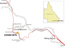 Map of the Camp Mountain train disaster, north-west of Brisbane
 -
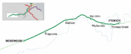
 Map of the Exhibition railway line, Brisbane
 -
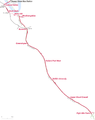
 Map of the Rosewood railway line, Queensland
 -
 Map of the proposed Springfield railway line, Brisbane
 -
 Map of the proposed Maroochydore railway line, Queensland
 -
-
 Map of the Gold Coast railway line, Queensland
 -
-
 Map of the Beenleigh railway line, Brisbane
 -
 Map of the Ipswich railway line, Brisbane
 -
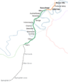
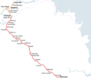
 Map of the Cleveland railway line, Brisbane
 -
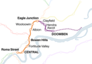 Map of the Doomben railway line, Brisbane
 -
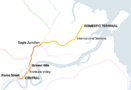 Map of the Airport railway line, Brisbane
 -
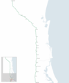
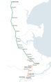 Map of the Caboolture railway line, Brisbane
 -
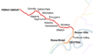 Map of the Ferny Grove railway line, Brisbane
 -
 Map of the Shorncliffe railway line, Brisbane
 -
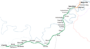
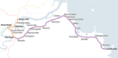
 Map of the Citytrain network spanning South East Queensland


