
Vilnius District Municipality
Vilnius District Municipality
Vilniaus rajono savivaldybė | |
|---|---|
 Flag  Coat of arms | |
 Location of Vilnius district municipality in Lithuania | |
 Map of Vilnius district municipality | |
| Country | |
| Ethnographic region | Dzūkija/Aukštaitija |
| County | |
| Capital | Vilnius |
| Elderships | |
| Government | |
| • Mayor | Robert Duchnevič[1] (Social Democratic Party of Lithuania) |
| Area | |
| • Total | 2,129 km2 (822 sq mi) |
| Population (2023)[2] | |
| • Total | 106,197 |
| • Density | 50/km2 (130/sq mi) |
| Time zone | UTC+2 (EET) |
| • Summer (DST) | UTC+3 (EEST) |
| Major settlements |
|
| Website | www |
Vilnius District Municipality (Lithuanian: Vilniaus rajono savivaldybė) is one of the 60 municipalities in Lithuania. It surrounds the capital city of Vilnius on three sides. The municipality is also bordered by Trakai district and Elektrėnai municipality in the west, Astravyets and Ashmyany districts of Belarus in the east, Širvintos, Molėtai and Švenčionys districts in the north and Šalčininkai district in the south.
The population of the district is one of the fastest growing in Lithuania because of the migration of Vilnius' inhabitants to the suburbs. It stood at 116,584 in January 2024,[3] up from 84 thousand in the early 1990s, meaning an increase by more than a third in less than 30 years.
History[edit]


Vilnius district municipality is situated in the territory once settled by the Baltic East Lithuanian Barrow Culture (c. 3/4th–11/12th century AD), and numerous archaeological sites from this period are situated within its borders. During the formation of the Grand Duchy of Lithuania, the major part of what is now Vilnius district municipality was the nucleus of the Duchy of Lithuania, while the territory to the north of Maišiagala belonged to the Neris Land. There is some evidence that Bukiškis just north of Vilnius whose historic name was Gedvydžiai could be associated with Duke Gedvydas and through this link – with Mindaugas.[4] According to Jan Długosz, the pagan ruler of Lithuania Algirdas was cremated in the sacred forest of Kukaveitis near Maišiagala after his death in Maišiagala castle in 1377.[5] Nemenčinė (1338), Maišiagala (1254, 1365) and Medininkai (1387), known from written sources from the 13th-14th centuries, were among the oldest settlements in Lithuania. These were trade and defense centers with castles as well as religious centers – after the Christianization of Lithuania, early churches were built here. As Vilnius was the capital of the Grand Duchy of Lithuania, the territory around the city was forming the very center of the state, so-called Lithuania proper. It was the major part of a much larger Vilnius Duchy and later – Vilnius Voivodeship. After the partitions of the Polish-Lithuanian Commonwealth, Vilna Governorate was formed and Vilensky Uyezd occupied all of what is now Vilnius district municipality. When Vilnius and its suburbs in 1923 were incorporated into Interwar Poland, what is now Vilnius district municipality was the core of Wilno-Troki County. After World War II, Vilnius district municipality was formed. The initially small Vilnius district (938 km2) was soon significantly enlarged, absorbing Naujoji Vilnia district (in 1959) and Nemenčinė district (in 1962) and parts of Ukmergė district, but transferring some smaller administrative territories to Molėtai district and Švenčionys district, including Pabradė (in 1962). After 1962 (then 2313 km2), there were only minor administrative reforms, attaching some territories from Vilnius district municipality (now 2129 km2) to Vilnius city. In March 1987, the villages of Pašilaičiai, Fabijoniškės, Kelmija, Raisteliai and parts of the villages of Pavilionys, Baltoji Vokė, Prašiškės, Bajorai, Buivydiškės, Grigaičiai and Vanaginė were attached to Vilnius city.[6] Almost all of the municipality belongs to the Vilnius urban belt, forming suburban environs of the capital city.[7]
Some projects, that may have been changed the district radically were not implemented.
During the interwar period, hydropower plant was started to be built in 1938 only to be abandoned in 1940. The reservoir between Turniškės and Nemenčinė was not created. During the 70s, a plan to build a pumped storage plant in Sudervė was too dropped off and such a plant was built in Kruonis instead.
Demographics[edit]
The district has significant Polish minority population in Lithuania, with 46% of the population claiming Polish ethnicity.[8] But the number has been dwindling from more than 80% in the late 1980s because of suburbanisation, age structure (younger newcomer inhabitants are mostly Lithuanians, while older population in villages are mostly Poles) and acculturation.
At the 2011 Census, Poles amounted to 52.07% out of 95,348 inhabitants. 32.47% were Lithuanians, 8.01% Russians, 4.17% Belarusians, 0.65% Ukrainians and 0.11% Jews.[9]
In 2021, according to the census results, ethnographic composition was the following: Poles – 46.75%, Lithuanians – 38.52%, Russians – 7.35%, Belarusians – 3.26%, Ukrainians – 0.63%, Other – 0.86% and 2.64% of inhabitants did not declare their ethnographic identity.[10]
Elderships[edit]
The municipality is divided into 23 elderships:


Structure[edit]


District structure.[13]
- one city – Nemenčinė;
- four small towns: Bezdonys, Maišiagala, Mickūnai, Šumskas
- 1091 villages.
Largest residential areas by population (2011[14] or 2021 - if specified):
- Nemenčinė – 5,054
- Skaidiškės – 4,133
- Rudamina (Vilnius) – 3,981
- Pagiriai (Vilnius) – 3,451
- Didžioji Riešė – 2,520
- Nemėžis – 2,498
- Avižieniai – 2,125
- Valčiūnai – 1,874
- Juodšiliai – 1,744
- Zujūnai – 1,660
- Maišiagala – 1,636
- Kalveliai – 1,592
- Galgiai – 1,426
- Mickūnai – 1,389
- Grigaičiai – 1,325
- Buivydiškės – 1,314
- Vaidotai – 1,287
- Riešė – 1,234
- Gineitiškės – 1,093
- Kalviškės – 974
- Bajorai – 945 (2021)
- Bukiškis – 922
- Paberžė – 919
- Šumskas – 919
- Marijampolis – 870
- Rastinėnai – 805 (2021)
- Rukainiai – 770
- Bendoriai – 764
- Bezdonys – 743
- Didžiosios Kabiškės – 716
- Mostiškės – 631
- Lavoriškės – 621
- Sudervė – 588 (2021)
- Anavilis – 574
- Glitiškės – 549
- Lindiniškės – 534 (2021)
- Brinkiškės – 532 (2021)
- Vėliučionys – 516
- Medininkai – 493
- Papiškės – 489 (2021)
- Pikeliškės – 458 (2021)
- Keturiasdešimt Totorių – 451
- Melekonys – 450 (2021)
- Saldenė – 446 (2021)
- Viktariškės – 446 (2021)
- Kuprioniškės – 424 (2021)
- Skirgiškės – 423 (2021)
- Pakalniškės – 423 (2021)
- Pikutiškės – 402 (2021)
- Daržininkai – 401 (2021)
- Parudaminys - 397 (2021)
- Skaisteriai - 389 (2021)
- Kena - 369 (2021)
International relations[edit]
Twin towns — Sister cities[edit]
Vilnius District Municipality is twinned with:
Gallery[edit]
-

-
 Sacred Daubos Oak in Neris Regional Park
 -
 Swamp near Šilėnai
 -
 Buivydai hillfort
 -
 Ilgutis lake near Keturiasdešimt Totorių
 -
 Stones "Three Brothers" near Sudervė
 -

-

-
 Wooden Old Believers church in Žemaitėliai
 -

-
 Wooden mosque in Keturiasdešimt Totorių
 -
 Tower chapel in Sudervė
 -
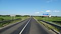
 Road near Marijampolis
 -

-

-
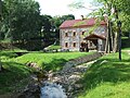 Liubavas mill-museum
 -
 Museum of Władysław Syrokomla in Bareikiškės
 -
 Road near Lavoriškės


_hillfort_2011_(1).jpg)


References[edit]
- ^ "ROBERT DUCHNEVIČ". vrk.lt (in Lithuanian).
- ^ Gyventojų skaičius metų pradžioje, 2024
- ^ 2024 01 01 Gyventoju skaičius pagal savivaldybes
- ^ „Būtovės slėpiniai: Kernavė ar Vilnius?“
- ^ Semaška, Algimantas (2006). Kelionių vadovas po Lietuvą: 1000 lankytinų vietovių norintiems geriau pažinti gimtąjį kraštą (in Lithuanian) (4th ed.). Vilnius: Algimantas. pp. 363–364. ISBN 9986-509-90-4.
- ^ Visuotinio 1989 m. gyventojų surašymo duomenys, Vilnius, 1993
- ^ THE METROPOLITAN REGIONS OF LITHUANIA. RESIDENTIAL DIFFERENTIATION IN THE XXI CENTURY
- ^ "Tautinių mažumų departamentas prie Lietuvos Respublikos Vyriausybės".
- ^ "Lithuania 2011 Census". Lietuvos statistikos departamentas. 2011. Archived from the original on 2012-01-11. Retrieved 2013-03-24.
- ^ [Apie rajoną. Teritorija ir gyventojai https://www.vrsa.lt/apie-rajona/teritorija-ir-gyventojai/5]
- ^ "Atviri duomenys | VĮ Registrų centras". www.registrucentras.lt. Retrieved 2021-01-07.
- ^ "Naujas detalus gyventojų žemėlapis". osp.stat.gov.lt (in Lithuanian). Retrieved 2021-01-07.
- ^ Główny Geodeta Kraju (2012). "Robocza wersja wykazu polskich nazw geograficznych świata (Glossary of geographical names)" (PDF file, direct download 261 KB). Litwa; ofic. Republika Litewska; Lietuva; ofic. Lietuvos Respublika. Komisja Standaryzacji Nazw Geograficznych (Commission for Standardization of Placenames). p. 27. Retrieved December 31, 2012.
- ^ Lietuvos statistikos departamentas. http://web.stat.gov.lt/uploads/docs/Gyventojai_gyvenamosiose_vietovese.xls
- ^ "Radom - Miasta partnerskie" [Radom - Partnership cities]. Miasto Radom [City of Radom] (in Polish). Archived from the original on 2013-04-03. Retrieved 2013-08-07.
