Wikipedia:Featured picture candidates/File:Jorge Aguiar 1492 MR.jpg
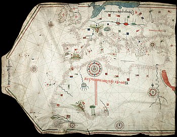
Portolan chart by Jorge d Aguiar[edit]
Voting period is over. Please don't add any new votes. Voting period ends on 19 Dec 2010 at 00:14:10 (UTC)

- Reason
- One of the very few high quality reproductions of portolan charts available in Commons
- Articles in which this image appears
- Portolan chart
- FP category for this image
- Wikipedia:Featured pictures/Diagrams, drawings, and maps/Maps
- Creator
- Jorge de Aguiar (1492)
- Support as nominator --Alvesgaspar (talk) 00:14, 10 December 2010 (UTC)
- Support per nom. Not a term I'd heard of. Noodle snacks (talk) 06:53, 10 December 2010 (UTC)
- Support fascinating. Purpy Pupple (talk) 08:14, 10 December 2010 (UTC)
- Comment Is the orientation correct? Or should it be rotated 90 degrees clockwise? SMasters (talk) 09:46, 10 December 2010 (UTC)
- I thought the same thing too, but then a closer inspection reveals that there appear to be words oriented in all kinds of directions so I suppose the orientation doesn't really matter. Purpy Pupple (talk) 10:59, 10 December 2010 (UTC)
- Info -- This is the common modern way of depicting the portolan charts, with the north-south axis of the Mediterranean shown as a vertical. At the time, there was no 'correct way' of orienting nautical charts: they were put in the positions that best fitted the present navigational use on board. As in all charts of this type, the geographical names were written perpendicularly to the coastline, as to avoid hiding important information, and their orientation changed throughout the chart, according to the orientation of the coastlines. Alvesgaspar (talk) 13:50, 10 December 2010 (UTC)
- Support Thanks for the explanation. It is fascinating indeed! SMasters (talk) 03:21, 11 December 2010 (UTC)
- Support cool. Nergaal (talk) 18:30, 15 December 2010 (UTC)
Promoted File:Jorge Aguiar 1492 MR.jpg --Makeemlighter (talk) 05:08, 19 December 2010 (UTC)
