
Adjuntas barrio-pueblo
Adjuntas barrio-pueblo
Pueblo de Adjuntas | |
|---|---|
Municipality Seat[1] | |
 The central plaza with its church in 2008 | |
 Location of Adjuntas barrio-pueblo within the municipality of Adjuntas shown in red | |
 Adjuntas barrio-pueblo Location of Puerto Rico | |
| Coordinates: 18°09′50″N 66°43′25″W / 18.163776°N 66.723544°W[2] | |
| Commonwealth | |
| Municipality | |
| Area | |
| • Total | 0.75 sq mi (1.9 km2) |
| • Land | 0.75 sq mi (1.9 km2) |
| • Water | 0.00 sq mi (0.0 km2) |
| Elevation | 1,614 ft (492 m) |
| Population (2010) | |
| • Total | 4,406 |
| • Density | 5,874.7/sq mi (2,268.2/km2) |
| Source: 2010 Census | |
| Time zone | UTC−4 (AST) |
| ZIP Codes | 00601, 00631 |
| Area code | 787/939 |
| Website | adjuntaspr |
Adjuntas barrio-pueblo is a barrio and the administrative center (seat) of Adjuntas, a municipality of Puerto Rico. Its population in 2010 was 4,406.[1][4][5][6]
As was customary in Spain, in Puerto Rico, the municipality has a barrio called pueblo which contains a central plaza, the municipal buildings (city hall), and a Catholic church. Fiestas patronales (patron saint festival) are held in the central plaza every year.[7][8]
The central plaza and its church[edit]
The central plaza, or square, is a place for official and unofficial recreational events and a place where people can gather and socialize from dusk to dawn. The Laws of the Indies, Spanish law, which regulated life in Puerto Rico in the early 19th century, stated the plaza's purpose was for "the parties" (celebrations, festivities) (Spanish: a propósito para las fiestas), and that the square should be proportionally large enough for the number of neighbors (Spanish: grandeza proporcionada al número de vecinos). These Spanish regulations also stated that the streets nearby should be comfortable portals for passersby, protecting them from the elements: sun and rain.[7]
Located across from the central plaza in Adjuntas barrio-pueblo is the Parroquia San Joaquín, a Roman Catholic church which was inaugurated in 1815.[9]
History[edit]
The location of modern-day Adjuntas barrio-pueblo was first settled in the Cidra River valley at the beginning of the 19th century, along an old road that connected Utuado with Ponce and the southern coast of Puerto Rico. At the time, the territory formed part of the municipal region of Coamo. A chapel was erected in 1805, which was later upgraded into a parish church by petition of the citizens of Adjuntas. The official founding of the pueblo happened on August 11, 1815, with Don Diego Maldonado being its official founder and first elected representative.[10] The settlement of Adjuntas was granted official "villa" status by the Spanish crown in 1894.[11]
Adjuntas barrio-pueblo was in Spain's gazetteers[12] until Puerto Rico was ceded by Spain in the aftermath of the Spanish–American War under the terms of the Treaty of Paris of 1898 and became an unincorporated territory of the United States. In 1899, the United States Department of War conducted a census of Puerto Rico finding that the population of Adjuntas barrio-pueblo (Pueblo) was 1,963.[13]
Landmarks and places of interest[edit]
- The Adjuntas Public Square (Plaza Pública de Adjuntas), located at the very center of town, is one of the highest in Puerto Rico, at almost 1,640 feet (500 m) in elevation. It hosts a large working thermometer, paying homage to some of the coldest recorded temperatures in Puerto Rico.[14] As it is custom in Puerto Rico, the plaza also hosts the city hall (alcaldía) and Roman Catholic parish church (Parroquia San Joaquín).
- Casa Pueblo (Spanish for "the people's house") is a non-profit community and educational organization dedicated to the protection of the environment. It is located in a historic Criollo house, and it often hosts cultural events, educational tours and classes. This organization is largely responsible for the creation of the nearby People's Forest (Bosque del Pueblo).
- The Washington Irving Grade School (Escuela Graduada Washington Irving) is a National Register of Historic Places-listed building located near the town plaza.
| Census | Pop. | Note | %± |
|---|---|---|---|
| 1900 | 1,963 | — | |
| 1910 | 1,406 | −28.4% | |
| 1920 | 1,729 | 23.0% | |
| 1930 | 2,376 | 37.4% | |
| 1940 | 3,856 | 62.3% | |
| 1950 | 5,262 | 36.5% | |
| 1960 | 5,318 | 1.1% | |
| 1970 | 5,319 | 0.0% | |
| 1980 | 5,239 | −1.5% | |
| 1990 | 5,081 | −3.0% | |
| 2000 | 4,980 | −2.0% | |
| 2010 | 4,406 | −11.5% | |
| U.S. Decennial Census 1899 (shown as 1900)[15] 1910-1930[16] 1930-1950[17] 1960[18] 1980-2000[19] 2010[20] | |||
Gallery[edit]
Places in Adjuntas barrio-pueblo:
-
![Washington Irving School, listed on the US National Register of Historic Places[21]](//upload.wikimedia.org/wikipedia/commons/thumb/c/c4/Escuela_Washington_Irving_2_-_Adjuntas_Puerto_Rico.jpg/302px-Escuela_Washington_Irving_2_-_Adjuntas_Puerto_Rico.jpg) Washington Irving School, listed on the US National Register of Historic Places[21]
Washington Irving School, listed on the US National Register of Historic Places[21] -
 Fountain at the central plaza of Adjuntas
 -
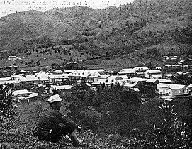 Adjuntas Pueblo in the early 20th century
![Washington Irving School, listed on the US National Register of Historic Places[21]](/wiki/File:Escuela_Washington_Irving_2_-_Adjuntas_Puerto_Rico.jpg)


See also[edit]
References[edit]
- ^ a b Puerto Rico: 2010 Population and Housing Unit Counts.pdf (PDF). U.S. Dept. of Commerce, Economics and Statistics Administration, US Census Bureau. 2010.
- ^ a b "US Gazetteer 2019". US Census. US Government.
- ^ U.S. Geological Survey Geographic Names Information System: Adjuntas barrio-pueblo
- ^ Picó, Rafael; Buitrago de Santiago, Zayda; Berrios, Hector H. Nueva geografía de Puerto Rico: física, económica, y social, por Rafael Picó. Con la colaboración de Zayda Buitrago de Santiago y Héctor H. Berrios. San Juan Editorial Universitaria, Universidad de Puerto Rico,1969.
- ^ Gwillim Law (20 May 2015). Administrative Subdivisions of Countries: A Comprehensive World Reference, 1900 through 1998. McFarland. p. 300. ISBN 978-1-4766-0447-3. Retrieved 25 December 2018.
- ^ "US Census Barrio-Pueblo definition". factfinder.com. US Census. Archived from the original on 13 May 2017. Retrieved 5 January 2019.
- ^ a b Santullano, Luis A. (10 March 2019). Mirada al Caribe. Vol. 54. Colegio de Mexico. pp. 75–78. doi:10.2307/j.ctvbcd2vs.12. JSTOR j.ctvbcd2vs.12.
- ^ Pariser, Harry S. (2003). Explore Puerto Rico, Fifth Edition. San Francisco: Manatee Press. pp. 52–55. Retrieved 10 February 2019.
- ^ Mari Mut, José A. (2013-08-28). Los Pueblos de Puerto Rico y Las Iglesias de Sus Plazas [The Pueblos of Puerto Rico, and the Churches of its Plazas] (PDF) (in Spanish). pp. 10–12. Retrieved 2020-12-14.
- ^ "Historia de Adjuntas – AdjuntasPR.com" (in Spanish). Retrieved 2023-01-15.
- ^ El Impacto de la Real Cédula de Gracia en Adjuntas en 1815 Archived September 19, 2011, at the Wayback Machine on Interamerican University of Puerto Rico; Martínez Román, José A.
- ^ "Anuario del comercio, de la industria, de la magistratura y de la administración. 1881". Biblioteca Nacional de España (in Spanish). p. 1614. Retrieved 4 April 2023.
- ^ Joseph Prentiss Sanger; Henry Gannett; Walter Francis Willcox (1900). Informe sobre el censo de Puerto Rico, 1899, United States. War Dept. Porto Rico Census Office (in Spanish). Imprenta del gobierno. p. 165.
- ^ "Plaza de Recreo Adjuntas". Discover Puerto Rico (in Spanish). Retrieved 2023-01-15.
- ^ "Report of the Census of Porto Rico 1899". War Department Office Director Census of Porto Rico. Archived from the original on July 16, 2017. Retrieved September 21, 2017.
- ^ "Table 3-Population of Municipalities: 1930 1920 and 1910" (PDF). United States Census Bureau. Archived (PDF) from the original on August 17, 2017. Retrieved September 21, 2017.
- ^ "Table 4-Area and Population of Municipalities Urban and Rural: 1930 to 1950" (PDF). United States Census Bureau. Archived (PDF) from the original on August 30, 2015. Retrieved September 21, 2014.
- ^ Census of Population, 1960: Number of Inhabitants, General Population Characteristics, General Social and Economic Characteristics, and Detailed Characteristics. Characteristics of the population. U.S. Bureau of the Census. 1963. pp. 97–101. Retrieved June 10, 2023.
- ^ "Table 2 Population and Housing Units: 1960 to 2000" (PDF). United States Census Bureau. Archived (PDF) from the original on July 24, 2017. Retrieved September 21, 2017.
- ^ Puerto Rico: 2010 Population and Housing Unit Counts.pdf (PDF). U.S. Dept. of Commerce Economics and Statistics Administration U.S. Census Bureau. 2010. Archived (PDF) from the original on 2017-02-20. Retrieved 2019-08-02.
- ^ "NPGallery Asset Detail". npgallery.nps.gov. Retrieved 2021-09-16.