Aillebrack
Aillebrack
An Aill Bhreac | |
|---|---|
Townland | |
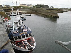
 Bunowen Pier in Aillebrack townland | |
| Coordinates: 53°25′04″N 10°07′08″W / 53.41773°N 10.11902°W | |
| Country | Ireland |
| Province | Connacht |
| County | County Galway |
| Irish grid reference | L589418 |
Aillebrack (Irish: An Aill Bhreac, meaning "the speckled cliff")[1] is a townland on the west coast of Connemara in County Galway, Ireland.[1] As of the 2011 census, the townland had a population of 122 people.[2]
Geography[edit]
Situated in the civil parish of Ballindoon, in the historical barony of Ballynahinch, Aillebrack is approximately 2.6 square kilometres (1.0 sq mi) in area.[3]
Lough Aillebrack, a "hard water" lake within the Slyne Head Peninsula Special Area of Conservation, is nearby.[4] The area is overlooked by Doon Hill.[5]
History[edit]
Evidence of ancient settlement in the townland includes several midden and holy well sites. The latter includes a well, known as the "Well of the Seven Daughters", near Doon Hill.[6][7] Bunowen Pier in Aillebrack was built c. 1820.[8]
There is a memorial stone and plaque in Aillebrack which commemorates the crew of a U.S. Navy Liberator aircraft that crashed off the nearby coast in 1944.[9]
Education[edit]
The local national (primary) school, Aillebrack National School, is situated near the village of Ballyconneely. Also known as St. Caillín's National School (after Saint Caillín),[5] it operates from a two-room school building which was built in 1945.[10]
The school, which was first built in the late 19th century, originally had just one room.[11] This school building was destroyed in a fire in 1940.[11] While the school was being rebuilt, lessons were moved to two rooms in nearby Bunowen Castle.[11] At that time, the castle was in a poor condition and "described as cold and draughty".[11] The school was rebuilt and reopened in 1945.[11] When the school at nearby Dunloughan closed in 1967, its 15 pupils transferred to Aillebrack school.[11] As of 2010, there were 27 children enrolled in Aillebrack National School.[10]
References[edit]
- ^ a b "An Aill Bhreac / Aillebrack". logainm.ie. Placenames Database of Ireland. Retrieved 19 February 2024.
- ^ "CD155 - Galway Population by Private Households, Occupied and Vacancy Rate". data.gov.ie. Central Statistics Office. Retrieved 19 February 2024.
Population [..] Townlands [..] Aillebrack, Bunowen, Co. Galway [..] 122
- ^ "Aillebrack Townland, Co. Galway". townlands.ie. Retrieved 19 February 2024.
- ^ "Slyne Head Peninsula SAC" (PDF). npws.ie. National Parks and Wildlife Service. Retrieved 19 February 2024.
- ^ a b "Aillebrack National School - Home". aillebrackns.ie. Retrieved 19 February 2024.
St. Caillin's National School Aillebrack [..] with Doon Hill [..] acting as a stunning backdrop, Aillebrack is a peaceful haven
- ^ Gosling, Paul (1993). Archaeological Inventory of County Galway: West Galway. p. 117.
Aillebrack An Aill Bhreak [..] Indicated 'Well of the Seven Daughters' [..] Holy well In a low-lying area close to NW foot of Doon Hill. Recorded by O'Flaherty in 1684
- ^ "Holy Family Church Ballyconeelly". clifdenparish.com. Retrieved 19 February 2024.
At Aillebrack, near Doon Hill, there is the 'Holy Well of the Seven Daughters'
- ^ "Aillebrack, Galway". buildingsofireland.ie. National Inventory of Architectural Heritage. Retrieved 19 February 2024.
- ^ "Aillebrack - Liberator Memorial". galwaycommunityheritage.org. Retrieved 19 February 2024.
- ^ a b "Whole School Evaluation Report - Scoil Náisiúnta Naomh Cáilín, Aillebrack, Ballyconneely, County Galway" (PDF). gov.ie. Department of Education. 5 March 2010. Retrieved 19 February 2024.
- ^ a b c d e f "Aillebrack National School - School History". aillebrackns.ie. Retrieved 19 February 2024.

