
Apache Peak
| Apache Peak | |
|---|---|
 West aspect, centered (Navajo Peak to right) | |
| Highest point | |
| Elevation | 13,441 ft (4,097 m)[1][2] |
| Prominence | 1,083 ft (330 m)[3] |
| Parent peak | North Arapaho Peak (13,508 ft)[3] |
| Isolation | 2.22 mi (3.57 km)[3] |
| Coordinates | 40°03′30″N 105°39′04″W / 40.0583790°N 105.6511043°W[4] |
| Naming | |
| Etymology | Apache |
| Geography | |
 Apache Peak Location in Colorado  Apache Peak Apache Peak (the United States) | |
| Country | United States |
| State | Colorado |
| County | Boulder / Grand |
| Protected area | Indian Peaks Wilderness |
| Parent range | Rocky Mountains Front Range[5] |
| Topo map | USGS Monarch Lake |
| Geology | |
| Age of rock | Precambrian[7] |
| Type of rock | Granite[6] |
| Climbing | |
| Easiest route | Hiking class 2[3] |
Apache Peak is a 13,441-foot (4,097 m) mountain summit on the boundary shared by Boulder County and Grand County, in Colorado, United States.[4]
Description[edit]
Apache Peak is set on the Continental Divide in the Front Range which is a subrange of the Rocky Mountains.[5] The mountain is located 21 miles (34 km) west of Boulder in the Indian Peaks Wilderness, on land managed by Arapaho National Forest and Roosevelt National Forest. It is the second-highest summit in the wilderness and third-highest in Grand County.[3] Precipitation runoff from the mountain's east slope drains into headwaters of South St. Vrain Creek, whereas the west slope drains to Monarch Lake thence Lake Granby via Cascade and Arapaho creeks. Topographic relief is significant as the summit rises 2,840 feet (866 m) above Wheeler Basin in one mile (1.6 km) and 2,460 feet (750 m) above Triangle Lake in one-half mile. An ascent of the peak involves hiking 12.5 miles (20.1 km) (round trip) with 3,400 feet (1,036 m) of elevation gain.[8] The mountain was named by Ellsworth Bethel,[9] and the toponym was officially adopted in 1914 by the United States Board on Geographic Names.[4]
Climate[edit]
According to the Köppen climate classification system, the mountain is located in an alpine subarctic climate zone with cold, snowy winters, and cool to warm summers.[10] Due to its altitude, it receives precipitation all year, as snow in winter and as thunderstorms in summer, with a dry period in late spring. This climate supports the Fair Glacier in the peak's northwest cirque and the Isabelle Glacier on the northeast slope.
Climbing[edit]
Established climbing routes on Apache Peak:[2]
- East slope – class 3
- Apache Couloir – class 3
- East Ledges – class 3
- Fair Glacier – class 3
- South Ridge – class 3
- Queens Way – class 2
Gallery[edit]
-
 West aspect of Apache Peak (left)
Navajo Peak centered, Arikaree Peak (right). -
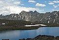
 East aspect of Navajo Peak (left, pyramid shape), Apache Peak (center), and Shoshoni Peak (right). Lake Isabelle to left.
 -
 East aspect
 -
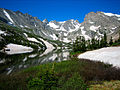 Apache Peak (center) from Lake Isabelle
 -
 Apache Peak / Navajo Peak viewed from the southwest at Lake Dorothy.
 -
 Navajo Peak, Apache Peak, and Shoshoni Peak reflected in Lake Isabelle


See also[edit]
References[edit]
- ^ Robert M. Ormes (1992), Guide to the Colorado Mountains, Johnson Books, ISBN 9781555661946, p. 64.
- ^ a b Gerry Roach (1998), Colorado's Indian Peaks, Fulcrum Publishing, ISBN 9781555914042
- ^ a b c d e "Apache Peak - 13,450' CO". listsofjohn.com. Retrieved April 27, 2023.
- ^ a b c "Apache Peak". Geographic Names Information System. United States Geological Survey, United States Department of the Interior. Retrieved April 27, 2023.
- ^ a b "Apache Peak, Colorado". Peakbagger.com. Retrieved April 27, 2023.
- ^ Geologic map of the Estes Park 30' x 60' quadrangle, north-central Colorado, W.A. Braddock, U.S. Geological Survey, 1984.
- ^ Lexicon of Geologic Names of the United States (including Alaska). Part 2 (1936), U.S. Government Printing Office, p. 2227.
- ^ Brittany Konsella, Frank Konsella (2017), Backcountry Ski & Snowboard Routes: Colorado, Mountaineers Books, ISBN 9781594858833
- ^ James Dziezynski (2012), Best Summit Hikes in Colorado, AdventureKEEN, ISBN 9780899977126, p. 64.
- ^ Peel, M. C.; Finlayson, B. L.; McMahon, T. A. (2007). "Updated world map of the Köppen−Geiger climate classification". Hydrol. Earth Syst. Sci. 11. ISSN 1027-5606.
External links[edit]
- Apache Peak: weather forecast
- Apache Peak climbing: Mountainproject.com