Argungu
Argungu | |
|---|---|
LGA and town | |
| Nickname: Gungun Nabame | |
| Coordinates: 12°44′N 4°31′E / 12.733°N 4.517°E | |
| Country | |
| State | Kebbi State |
| Government | |
| • Sarkin Kabbi | Alhaji Samaila Muhammad Mera |
| Population (2007) | |
| • Total | 47,064 |
| Time zone | UTC+1 (WAT) |
 | |
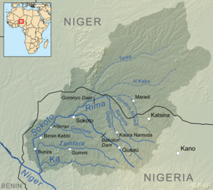
Argungu is a city in Nigeria's Kebbi State, situated on the Sokoto River. As of 2007 Argungu had an estimated population of 47,064.[1] The city is the seat of the Argungu Emirate, a traditional state. The city is a major agricultural center for the area, with key crops including tobacco, peanuts, rice, millet, wheat, and sorghum. The city also hosts an annual international fishing festival[2] which was suspended for 11 years. The Argungu fishing festival was held again in the year 2020 from March 11–14
Argungu have a museum where the historic turbulence and artifactare being kept, and displayed, it is called Kanta museum AKA Gidan Nabame.The dead emirs of the emirates are also buried in the museum.
History[edit]
After the Hausa state of Kebbi was conquered by the Fulani Empire in 1808, Kebbi's rulers fled to Argungu to found a new emirate. Though the neighboring Hausa state of Gwandu[3] conquered Kebbi in 1831, it was unable to fully secure control of Argungu, and a series of revolts followed. By the end of the century, Argungu had become a de facto independent state, though it was again conquered by the British in 1902.
Geography[edit]
Argungu Local Government Area experiences two distinct seasons, namely the rainy season and the dry season. The dry season is characterized by scorching temperatures, with an average temperature in the area reaching around 34 degrees Celsius. The region maintains an average humidity level of approximately 24 percent. Its landscape predominantly consists of dry and arid plains, punctuated by scattered hills and other elevated landforms.[4][5]
Economy[edit]
Agriculture plays a pivotal role in the economic landscape of Argungu Local Gvernment Araea, renowned for the cultivation of various crops including tobacco, groundnut, rice, sorghum, and millet. Fishing also holds significant importance in the local economy, while trade thrives in the region. Markets such as the Argungu Central Market serve as bustling hubs where a diverse array of commodities are exchanged.[4]
Climate[edit]
The district of Argungu experiences a tropical wet and dry climate, with a yearly temperature of 33.55 °C, 4.09% higher than Nigeria's averages.[6][7]
Argungu is seeing a positive trend in rising temperatures and a negative trend in falling temperatures, resulting in a warmer and colder climate.[8]
Museum[edit]

The building of the Kanta Museum, adjacent to the main market was built in 1831 and named after Muhammadu Kanta, who founded the Kebbi Kingdom in 1515. It was erected by Yakubu Nabame, a former Emir of Kebbi, and served as the Emir's palace until 1942 when the British built a new administrative palace during the reign of Muhammed Sani. After the building became vacant, on July 1, 1958, it opened as a museum, offering an insight into the turbulent history of Kebbi State. The museum is divided into eleven compartments and has a notable collection of weapons, consisting of charms, spears, swords, wood, stones, bows and arrows, local guns and even drums on display. The museum is also known to be a place where dead emirs of the local government are buried.[9]
See also[edit]
References[edit]
- ^ "The World Gazetteer". Archived from the original on October 1, 2007. Retrieved 2007-04-04.
- ^ "UNESCO - Argungu international fishing and cultural festival". ich.unesco.org. Retrieved 2020-10-06.
- ^ Balogun, S. A. (1974). "THE PLACE OF ARGUNGU IN GWANDU HISTORY". Journal of the Historical Society of Nigeria. 7 (3): 403–415. ISSN 0018-2540.
- ^ a b "Argungu Local Government Area". www.manpower.com.ng. Retrieved 2023-10-03.
- ^ "Argungu | Fishing Festival, Kebbi State, Etsu Nupe | Britannica". www.britannica.com. Retrieved 2023-10-03.
- ^ "Argungu, Kebbi, NG Climate Zone, Monthly Averages, Historical Weather Data". tcktcktck.org. Retrieved 2023-09-10.
- ^ "Argungu Climate, Weather By Month, Average Temperature (Nigeria) - Weather Spark". weatherspark.com. Retrieved 2023-09-10.
- ^ "Climate Change Argungu". meteoblue. Retrieved 2023-11-18.
- ^ Ayo Okulaja. "The charm of Argungu Museum". Next. Archived from the original on 2011-07-21. Retrieved 2010-10-08.
12°44′N 4°31′E / 12.733°N 4.517°E


