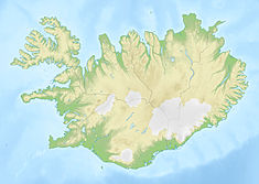
Blanda Power Station
| Blanda Power Station | |
|---|---|
 Blanda power station | |
| Country | Iceland |
| Coordinates | 65°24′57.9″N 19°49′12.0″W / 65.416083°N 19.820000°W |
| Operator(s) | Landsvirkjun |
| Spillway volumetric flow rate | 60 m3/s (2,100 cu ft/s) |
| Reservoir | |
| Normal elevation | 287 m |
| Power Station | |
| Commission date | 1991 |
| Turbines | 3 × 50 MW Francis Turbines |
| Installed capacity | 150 MW |
| Annual generation | 990 GW·h |
| Website Official website | |
Blanda Power Station (Icelandic: Blöndustöð [ˈplœntʏˌstœːθ]) is a dam and hydroelectric on the Blanda River within the northern edge of the highlands in Iceland.[1]
The Blanda Station came on-line in 1991. It is located on the northern edge of the high-lands near the end of the Kjalvegur Mountain Road. To the north is a view over the Blöndu-dalur Valley where the River Blanda flows out to the sea near the town of Blönduós. The Blanda Station is an underground plant, located approximately 230 metres below the surface.[1][2]
References[edit]
- ^ a b "Blöndustöð Power Station". Landsvirkjun. Archived from the original on 2022-02-10. Retrieved 2022-02-10.
- ^ "Blanda Power Station". NAT. 2018-10-30. Archived from the original on 2022-02-10. Retrieved 2022-02-10.

